Eastern Mojave Vegetation
|
Eastern Mojave Vegetation
| McKenzie Pass, Deschutes County, Oregon. |
|
Gazetteer Query: G.N.I.S.
|
||
|
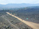
McKenzie Pass, elevation 5,325 feet (1,623 m),[1] is a mountain pass in the Cascade Range in central Oregon in the United States.[2]
It is located at the border of Linn and Deschutes counties,[2] approximately 25 miles (40 km) northwest of Bend,[3] between the Three Sisters to the south and Mount Washington to the north. Oregon Route 242 goes over the pass.[1]
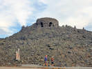
At the summit of the pass, Oregon Route 242 crosses a 65-square-mile (170 km2) lava flow just west of Sisters. Surrounded by lava, the Dee Wright Observatory was constructed in 1935 by Civilian Conservation Corps workers and named after their foreman. Visitors climb to the observatory to view the Cascade peaks visible from McKenzie Pass. Also near the summit is Clear Lake, a renowned location for fresh-water diving.
Articles that refer to this location:
| ||
| No collections made at this location. | ||
| If you have a question or a comment you may write to me at: tas4@schweich.com I sometimes post interesting questions in my FAQ, but I never disclose your full name or address. |
A, B, C,
D, E, F,
G, H, I,
J, K, L,
M, Date and time this article was prepared:11:12:45 AM, 5/10/2024. | |