Eastern Mojave Vegetation
Tom Schweich
|
Eastern Mojave Vegetation
| U. S. Highway 6 |
|
Tom Schweich |

|
(No Preface) | ||||||||||||||||||||||||||||||||||||||||||||||||||||||||||||||||||||||||||||||||||||||||||||||||||||||||||||||||||||||||||||||||||||||||||||||||||||||||||||||||||||||||||||||||||||||||||||||||||||||||||||||||||||||||||||||||||||||||||||||||||||||||||||||||||||||||||||||||||||||||||||||||||||||
|
Junction: Province Lands Road End of Road. | |||||||||||||||||||||||||||||||||||||||||||||||||||||||||||||||||||||||||||||||||||||||||||||||||||||||||||||||||||||||||||||||||||||||||||||||||||||||||||||||||||||||||||||||||||||||||||||||||||||||||||||||||||||||||||||||||||||||||||||||||||||||||||||||||||||||||||||||||||||||||||||||||||||||
|
|
Provincetown, MA | ||||||||||||||||||||||||||||||||||||||||||||||||||||||||||||||||||||||||||||||||||||||||||||||||||||||||||||||||||||||||||||||||||||||||||||||||||||||||||||||||||||||||||||||||||||||||||||||||||||||||||||||||||||||||||||||||||||||||||||||||||||||||||||||||||||||||||||||||||||||||||||||||||||||
|
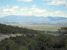
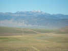
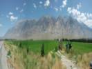
Nebraska above
Colorado below | |||||||||||||||||||||||||||||||||||||||||||||||||||||||||||||||||||||||||||||||||||||||||||||||||||||||||||||||||||||||||||||||||||||||||||||||||||||||||||||||||||||||||||||||||||||||||||||||||||||||||||||||||||||||||||||||||||||||||||||||||||||||||||||||||||||||||||||||||||||||||||||||||||||||
|
Other articles:
|
Junction: Colorado State Highway 14, on 3rd Street at Main Street. | ||||||||||||||||||||||||||||||||||||||||||||||||||||||||||||||||||||||||||||||||||||||||||||||||||||||||||||||||||||||||||||||||||||||||||||||||||||||||||||||||||||||||||||||||||||||||||||||||||||||||||||||||||||||||||||||||||||||||||||||||||||||||||||||||||||||||||||||||||||||||||||||||||||||
|
Other articles:
|
Junction: US Interstate 25 | ||||||||||||||||||||||||||||||||||||||||||||||||||||||||||||||||||||||||||||||||||||||||||||||||||||||||||||||||||||||||||||||||||||||||||||||||||||||||||||||||||||||||||||||||||||||||||||||||||||||||||||||||||||||||||||||||||||||||||||||||||||||||||||||||||||||||||||||||||||||||||||||||||||||
|
Other articles:
|
Junction: Union Street, Simms Street | ||||||||||||||||||||||||||||||||||||||||||||||||||||||||||||||||||||||||||||||||||||||||||||||||||||||||||||||||||||||||||||||||||||||||||||||||||||||||||||||||||||||||||||||||||||||||||||||||||||||||||||||||||||||||||||||||||||||||||||||||||||||||||||||||||||||||||||||||||||||||||||||||||||||
|
Other articles:
|
Junction: Indiana Street | ||||||||||||||||||||||||||||||||||||||||||||||||||||||||||||||||||||||||||||||||||||||||||||||||||||||||||||||||||||||||||||||||||||||||||||||||||||||||||||||||||||||||||||||||||||||||||||||||||||||||||||||||||||||||||||||||||||||||||||||||||||||||||||||||||||||||||||||||||||||||||||||||||||||
|
Other articles:
|
Junction: US Interstate 70, westbound access only. | ||||||||||||||||||||||||||||||||||||||||||||||||||||||||||||||||||||||||||||||||||||||||||||||||||||||||||||||||||||||||||||||||||||||||||||||||||||||||||||||||||||||||||||||||||||||||||||||||||||||||||||||||||||||||||||||||||||||||||||||||||||||||||||||||||||||||||||||||||||||||||||||||||||||
|
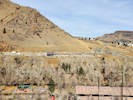
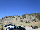
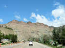
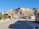
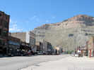
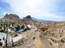
Locations: Golden. |
Golden below | ||||||||||||||||||||||||||||||||||||||||||||||||||||||||||||||||||||||||||||||||||||||||||||||||||||||||||||||||||||||||||||||||||||||||||||||||||||||||||||||||||||||||||||||||||||||||||||||||||||||||||||||||||||||||||||||||||||||||||||||||||||||||||||||||||||||||||||||||||||||||||||||||||||||
|
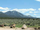
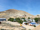
Locations: Green Mountain. |
Green Mountain to the south. | ||||||||||||||||||||||||||||||||||||||||||||||||||||||||||||||||||||||||||||||||||||||||||||||||||||||||||||||||||||||||||||||||||||||||||||||||||||||||||||||||||||||||||||||||||||||||||||||||||||||||||||||||||||||||||||||||||||||||||||||||||||||||||||||||||||||||||||||||||||||||||||||||||||||
|
Other articles:
|
Junction: US Highway 40, Colfax Avenue | ||||||||||||||||||||||||||||||||||||||||||||||||||||||||||||||||||||||||||||||||||||||||||||||||||||||||||||||||||||||||||||||||||||||||||||||||||||||||||||||||||||||||||||||||||||||||||||||||||||||||||||||||||||||||||||||||||||||||||||||||||||||||||||||||||||||||||||||||||||||||||||||||||||||
|
Other articles:
|
Intersection: Ulysses Street, accessible from westbound lanes only. | ||||||||||||||||||||||||||||||||||||||||||||||||||||||||||||||||||||||||||||||||||||||||||||||||||||||||||||||||||||||||||||||||||||||||||||||||||||||||||||||||||||||||||||||||||||||||||||||||||||||||||||||||||||||||||||||||||||||||||||||||||||||||||||||||||||||||||||||||||||||||||||||||||||||
| Junction: Colorado Highway 470, Johnson Road | |||||||||||||||||||||||||||||||||||||||||||||||||||||||||||||||||||||||||||||||||||||||||||||||||||||||||||||||||||||||||||||||||||||||||||||||||||||||||||||||||||||||||||||||||||||||||||||||||||||||||||||||||||||||||||||||||||||||||||||||||||||||||||||||||||||||||||||||||||||||||||||||||||||||
|
Other articles:
|
Junction:
| ||||||||||||||||||||||||||||||||||||||||||||||||||||||||||||||||||||||||||||||||||||||||||||||||||||||||||||||||||||||||||||||||||||||||||||||||||||||||||||||||||||||||||||||||||||||||||||||||||||||||||||||||||||||||||||||||||||||||||||||||||||||||||||||||||||||||||||||||||||||||||||||||||||||
|
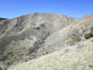
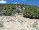
Locations: Deadman Gulch. Kinney Run. |
Highway crosses Deadman Gulch, as it is identified by BGN, or “Kinney Run” as it seems to be called locally. The Kinney Run Trail also crosses under the highway, but cannot be accessed here. | ||||||||||||||||||||||||||||||||||||||||||||||||||||||||||||||||||||||||||||||||||||||||||||||||||||||||||||||||||||||||||||||||||||||||||||||||||||||||||||||||||||||||||||||||||||||||||||||||||||||||||||||||||||||||||||||||||||||||||||||||||||||||||||||||||||||||||||||||||||||||||||||||||||||
|
Other articles:
|
Junction:
| ||||||||||||||||||||||||||||||||||||||||||||||||||||||||||||||||||||||||||||||||||||||||||||||||||||||||||||||||||||||||||||||||||||||||||||||||||||||||||||||||||||||||||||||||||||||||||||||||||||||||||||||||||||||||||||||||||||||||||||||||||||||||||||||||||||||||||||||||||||||||||||||||||||||
|
Other articles:
Locations: Landing Zone. |
Parking for Chimney Gulch Trail, and paraglider landing area. | ||||||||||||||||||||||||||||||||||||||||||||||||||||||||||||||||||||||||||||||||||||||||||||||||||||||||||||||||||||||||||||||||||||||||||||||||||||||||||||||||||||||||||||||||||||||||||||||||||||||||||||||||||||||||||||||||||||||||||||||||||||||||||||||||||||||||||||||||||||||||||||||||||||||
|
Junction:
US Highway 6 turns west, up Clear Creek Canyon to I-70. | |||||||||||||||||||||||||||||||||||||||||||||||||||||||||||||||||||||||||||||||||||||||||||||||||||||||||||||||||||||||||||||||||||||||||||||||||||||||||||||||||||||||||||||||||||||||||||||||||||||||||||||||||||||||||||||||||||||||||||||||||||||||||||||||||||||||||||||||||||||||||||||||||||||||
|
Other articles:
Locations:
Gateway Trailhead.
|
Gateway Trailhead, Peaks to Plains TrailParking lot and trailhead facilities constructed 2019-2021. | ||||||||||||||||||||||||||||||||||||||||||||||||||||||||||||||||||||||||||||||||||||||||||||||||||||||||||||||||||||||||||||||||||||||||||||||||||||||||||||||||||||||||||||||||||||||||||||||||||||||||||||||||||||||||||||||||||||||||||||||||||||||||||||||||||||||||||||||||||||||||||||||||||||||
|
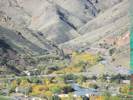
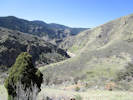
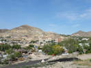
Locations:
Clear Creek Canyon.
Golden.
|
Golden above
Mouth of Clear Creek Canyon. | ||||||||||||||||||||||||||||||||||||||||||||||||||||||||||||||||||||||||||||||||||||||||||||||||||||||||||||||||||||||||||||||||||||||||||||||||||||||||||||||||||||||||||||||||||||||||||||||||||||||||||||||||||||||||||||||||||||||||||||||||||||||||||||||||||||||||||||||||||||||||||||||||||||||
|
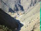
Other articles:
Locations:
Clear Creek Canyon.
Clear Creek Canyon Park.
|
| ||||||||||||||||||||||||||||||||||||||||||||||||||||||||||||||||||||||||||||||||||||||||||||||||||||||||||||||||||||||||||||||||||||||||||||||||||||||||||||||||||||||||||||||||||||||||||||||||||||||||||||||||||||||||||||||||||||||||||||||||||||||||||||||||||||||||||||||||||||||||||||||||||||||
|
Other articles:
Locations:
Clear Creek Canyon Park.
|
|||||||||||||||||||||||||||||||||||||||||||||||||||||||||||||||||||||||||||||||||||||||||||||||||||||||||||||||||||||||||||||||||||||||||||||||||||||||||||||||||||||||||||||||||||||||||||||||||||||||||||||||||||||||||||||||||||||||||||||||||||||||||||||||||||||||||||||||||||||||||||||||||||||||
|
Other articles:
Locations:
Indian Gulch.
|
Indian Gulch. | ||||||||||||||||||||||||||||||||||||||||||||||||||||||||||||||||||||||||||||||||||||||||||||||||||||||||||||||||||||||||||||||||||||||||||||||||||||||||||||||||||||||||||||||||||||||||||||||||||||||||||||||||||||||||||||||||||||||||||||||||||||||||||||||||||||||||||||||||||||||||||||||||||||||
|
Other articles:
|
Tunnel 1 Trailhead | ||||||||||||||||||||||||||||||||||||||||||||||||||||||||||||||||||||||||||||||||||||||||||||||||||||||||||||||||||||||||||||||||||||||||||||||||||||||||||||||||||||||||||||||||||||||||||||||||||||||||||||||||||||||||||||||||||||||||||||||||||||||||||||||||||||||||||||||||||||||||||||||||||||||
|
Other articles:
Locations:
Indian Gulch.
|
Tunnel 1 | ||||||||||||||||||||||||||||||||||||||||||||||||||||||||||||||||||||||||||||||||||||||||||||||||||||||||||||||||||||||||||||||||||||||||||||||||||||||||||||||||||||||||||||||||||||||||||||||||||||||||||||||||||||||||||||||||||||||||||||||||||||||||||||||||||||||||||||||||||||||||||||||||||||||
|
Other articles:
|
|||||||||||||||||||||||||||||||||||||||||||||||||||||||||||||||||||||||||||||||||||||||||||||||||||||||||||||||||||||||||||||||||||||||||||||||||||||||||||||||||||||||||||||||||||||||||||||||||||||||||||||||||||||||||||||||||||||||||||||||||||||||||||||||||||||||||||||||||||||||||||||||||||||||
|
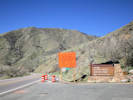
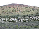
Locations: Guy Gulch. |
Guy Gulch | ||||||||||||||||||||||||||||||||||||||||||||||||||||||||||||||||||||||||||||||||||||||||||||||||||||||||||||||||||||||||||||||||||||||||||||||||||||||||||||||||||||||||||||||||||||||||||||||||||||||||||||||||||||||||||||||||||||||||||||||||||||||||||||||||||||||||||||||||||||||||||||||||||||||
|
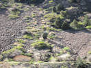
Locations: Beaver Brook. |
Tunnel 2, Beaver Brook. | ||||||||||||||||||||||||||||||||||||||||||||||||||||||||||||||||||||||||||||||||||||||||||||||||||||||||||||||||||||||||||||||||||||||||||||||||||||||||||||||||||||||||||||||||||||||||||||||||||||||||||||||||||||||||||||||||||||||||||||||||||||||||||||||||||||||||||||||||||||||||||||||||||||||
| Tunnel 3 | |||||||||||||||||||||||||||||||||||||||||||||||||||||||||||||||||||||||||||||||||||||||||||||||||||||||||||||||||||||||||||||||||||||||||||||||||||||||||||||||||||||||||||||||||||||||||||||||||||||||||||||||||||||||||||||||||||||||||||||||||||||||||||||||||||||||||||||||||||||||||||||||||||||||
|
Other articles:
Locations:
Clear Creek Canyon Park.
|
Mayhem Gulch, parking and trailhead for Clear Creek Canyon Park. | ||||||||||||||||||||||||||||||||||||||||||||||||||||||||||||||||||||||||||||||||||||||||||||||||||||||||||||||||||||||||||||||||||||||||||||||||||||||||||||||||||||||||||||||||||||||||||||||||||||||||||||||||||||||||||||||||||||||||||||||||||||||||||||||||||||||||||||||||||||||||||||||||||||||
|
Jefferson County above
Clear Creek County below | |||||||||||||||||||||||||||||||||||||||||||||||||||||||||||||||||||||||||||||||||||||||||||||||||||||||||||||||||||||||||||||||||||||||||||||||||||||||||||||||||||||||||||||||||||||||||||||||||||||||||||||||||||||||||||||||||||||||||||||||||||||||||||||||||||||||||||||||||||||||||||||||||||||||
|
Other articles:
|
Junction: CO State Highway 119, to Central City, Nederland and back out on the plains through Boulder. | ||||||||||||||||||||||||||||||||||||||||||||||||||||||||||||||||||||||||||||||||||||||||||||||||||||||||||||||||||||||||||||||||||||||||||||||||||||||||||||||||||||||||||||||||||||||||||||||||||||||||||||||||||||||||||||||||||||||||||||||||||||||||||||||||||||||||||||||||||||||||||||||||||||||
|
Other articles:
|
This location, 2.3 miles east of the junction of US 6 and US 40, is the probable location of Mellichamp & Nesom collection of P. vitulifera. Junction: CO State Highway 119, to Central City, Nederland and back out on the plains through Boulder. | ||||||||||||||||||||||||||||||||||||||||||||||||||||||||||||||||||||||||||||||||||||||||||||||||||||||||||||||||||||||||||||||||||||||||||||||||||||||||||||||||||||||||||||||||||||||||||||||||||||||||||||||||||||||||||||||||||||||||||||||||||||||||||||||||||||||||||||||||||||||||||||||||||||||
Junction: US Highway 40, turns south similar to the current route of US Interstate 70 over Floyd Hill and through Mt. Vernon Canyon.
|
|
Other articles:
Junction: US Interstate 70, west.
|
|
Other articles:
Junction: US Interstate 70
|
|
Other articles:
Pullout at a switchback in the road.
|
|
Other articles:
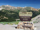
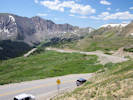
Locations:
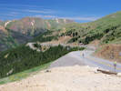
Loveland Pass.
| Clear Creek County above Loveland Pass, elevation 11,995 ft., 3656 m.
Summit County below
|
Other articles:
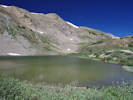
Locations:
Pass Lake.
| Pass LakeGlacial tarn near the top of Loveland Pass.
|
Other articles:
Junction: County Road 5 “Montezuma Road”, to Montezuma, and the Peru Creek basin and the inlet to Vidler Tunnel.
|
|
Other articles:
Junction: Roberts Tunnel Access Road, to the intake of the Roberts Tunnel. This road may be gated.
|
|
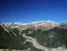
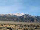
Locations: Dillon Reservoir.
| Dillon ReservoirReservoir at the confluence of the Snake River, the Blue River, and Tenmile Creek. Store water for Denver, which is sent by way of the Harold D. Roberts Tunnel to the South Platte River.
|
Locations: Dillon.
| Dillon
|
Other articles:
Junction: US Interstate 70
|
|
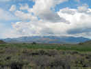
Colorado above ... | Utah below
|
Other articles:
Junction: US Interstate 70, just west of Green River, Utah.
| US Highway 6 diverges north from the route of I-70, passing through Price, Utah, en route to Spanish Fork, Utah.
|
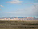
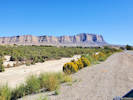
Other articles:
View of the southeast edge of the San Rafael Swell.
|
|
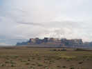
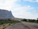
Other articles:
Beckwith Plateau from the south; photograph taken at a small rise in US Highway 6, just north of Interstate 70.
|
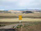
|
Desert Siding
|
|
Other articles:
Locations: Beckwith Plateau.
Beckwith Plateau to the east.
|
|
Literature Cited:
Other articles:
Junction: Green River Cut-Off Road (EM401)
|
|
Cross Price River
|
|
Other articles:
|
|
Literature Cited:
Locations: Woodside.
| Woodside
|
Locations: Summerville Wash.
Summerville Wash empties into Price River.
|
|
Horse Canyon Road
|
|
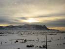
Other articles:
View of Beckwith Plateau from Amtrak's California Zephyr on a winter morning.
|
|
Other articles:
Junction: Drill Road
|
|
Other articles:
Locations: Sunnyside Junction.
| Sunnyside Junction
|
Other articles:
Junction: Mounds Road
|
|
Other articles:
View of Wellington, Utah, from beside US Highway 6.
|
|
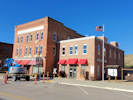
Locations: Wellington.
| Wellington
|
Other articles:
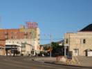
Locations: Price.
| Price
|
Other articles:
Junction: Utah Highway 10, southwest to US I-70.
|
|
Other articles:
Entering Helper from the south on US Highway 6.
|
|
Other articles:
Locations:
Helper.
| Helper
|
Other articles:
Junction: US Highway 191, north to Vernal, south to US I-70
|
|
Locations: Castle Gate.
| Castle Gate
|
Other articles:
Junction: Utah Highway 96, to Scofield Reservoir, Clear Creek, and a canyon named Miller Canyon, where I thought Marcus E. Jones might have collected Frasera albomarginata. It turns out, though, that he was referring to another Miller Canyon far to the south.
|
|
Other articles:
Junction: US Interstate 15, north.
|
|
| Spanish Fork
|
Other articles:
Junction: US Interstate 15, south.
|
|
Locations: Santaquin.
| Santaquin
|
| DeltaDelta
|
Other articles:
| Note: From Ely, Nevada to Delta, Utah, U. S. Highway 6 and U. S. Highway 50 share the same route. Please jump to U. S. Highway 50 for commentary.
|
Other articles:
Locations: Ely.
| ElyJunction:
|
Murry Springs
|
|
Murry Rock
|
|
Natural Arch
|
|
Other articles:
Small canyon to northwest.
|
|
Other articles:
Locations: Murray Summit.
| Murray SummitElevation 7,323 ft.Frasera albomarginata collected hear here, UC1434030.
|
Other articles:
Ward Mountain Recreation Area.
|
|
Other articles:
|
|
Other articles:
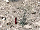
Locations: Lion Spring Wash.
Crossing Lion Spring Wash
|
|
Junction: National Forest Road 455 | This road accesses Lower Terrace and Upper Terrace, by way of Lion Spring Wash. There is at at least one collection of Frasera albomarginata made along this road.
|
Locations: White Sage Wash.
Crossing White Sage Wash
|
|
Other articles:
Locations: Ward Mountain.
Ward Mountain, to the east, in the north part of the Egan Range. | There is an Edmund Jaeger collection of Frasera albomarginata from Ward Mountain.
|
Junction: Headhouse Road | This looks like a good road to use for Lower and Upper Terrace.
|
There is a landstrip just south of the junction with Headhouse Road.
|
|
Other articles:
Junction: NV Hwy 318, south through the White River Valley to US Highway 93 near Hiko, Nevada.
|
|
Cross Nye County Route 10, also apparently known as "Long Valley Road." The USGS identifies this as Ellison Creek.
|
|
National Forest Road 405 to White River Campground and Currant Mountain Wilderness.
|
|
Other articles:
Cross the White River.
|
|
Other articles:
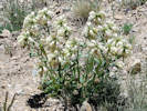
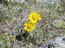
A. Thiem collected Frasera albomarginata in the hills east of the highway.
|
|
Other articles:
|
|
White Pine County above
| Nye County below
|
Other articles:
Locations: Currant Summit.
| Currant Summit
|
Other articles:
|
|
Literature Cited:
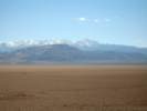
Locations: White Pine Range.
White Pine Mountains are north of US Highway 6 between Currant and Currant Summit. | Kartesz (1988) states that Frasera albomarginata is found in the White Pine Range.
|
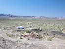
The Currant Creek Remote Automated Weather Station (RAWS) is south of the highway.
Data from this weather station can be found at:
http://www.met.utah.edu/cgi-bin/droman/meso_base.cgi?stn=CCRN2.
|
|
Other articles:
Locations: Currant.
| CurrantJunction: Nevada State Route 379David D. Keck collected Frasera albomarginata east of Currant.
|
Other articles:
Junction: Wells Station Road, southeast through the northern Grant Range, to Wells Station Summit, and then across the White River Valley to Nevada State Route 318 between Sunnyside and Lund.
|
|
Other articles:
|
|
Other articles:
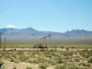
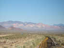
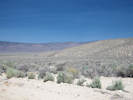
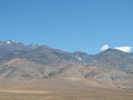
View across Railroad Valley to the Grant Range.
|
|
Lockes
|
|
Black Rock Summit, elevation 6257 ft.
|
|
Junction: Lunar Crater Road.
|
|
Sandy Summit, elevation 6030 ft.
|
|
Other articles:
Locations: Warm Springs.
| Warm SpringsJunction:
Hot Creek Range to the north; Kawich Range to the south.
|
Literature Cited:
| Stop 5-1 of Cook & Corboy (2004, pp. 97-98)
|
Literature Cited:
| Stop 5-2 of Cook & Corboy (2004, pp. 97-98)
|
Literature Cited:
| Stop 5-3 of Cook & Corboy (2004, pp. 97-98)
|
The White River is to the southeast of the highway.
|
|
Other articles:
Junction: Railroad Valley Road, south, down the east side of Railroad Valley Road, to NV State Route 375.
|
|
| Monitor Range
|
| Ralston Valley
|
Literature Cited:
| San Antonio Mountains"Near Tonopah along the southern rim of the Great Basin Desert, shadscale forms an ecotone separating the creosote and sagebrush zones where winters are too cold for creosote bush and where the climate is, too dry for sagebrush. Here shadscale with a clear tolerance for extremes in temperature. aridity and salty soil than either of these two dominant plants looks out over the shimmering heat waves rising from the Mojave Desert (Trimble, 1989)."
|
Other articles:
Junction: Nevada Highway 378, north through the Big Smoky Valley to US Highway 50.
|
|
Other articles:
Locations: Tonopah.
| TonopahJunction: US Highway 95, south to Las Vegas.
|
Other articles:
Intersection: McCullouch Avenue, to Tonopah Historic Mining Park.
|
|
Other articles:
|
|
Other articles:
Junction: Nevada State Route 89, north to Gabbs.
|
|
Other articles:
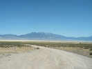
View west to Monte Cristo Range.
|
|
Other articles:
|
|
Between Tonopah and Coaldale, U. S. Hwy 6 and U. S. Hwy 95 share a route.
|
|
| Big Smokey Valley
|
Other articles:
| Blair JunctionJunction: Nevada Highway 265, south to Silver Peak.
|
Other articles:
| CoaldaleJunction: US Highway 95, north to such garden spots as Mina, Luning, and Hawthorne.
|
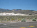
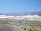
Other articles:
Locations:
Columbus Salt Marsh.
| Columbus Salt Marsh
|
Other articles:
Junction: Nevada State Route 773, south to NV State Route 264 in Fish Lake Valley.
|
|
Literature Cited:
Locations: The Gap.
Approximately 3 miles south is "The Gap" through which Fish Lake Valley drains into Columbus Salt Marsh.
|
|
Other articles:
Locations:
Volcanic Hills.
White Mountains.
The Volcanic Hills could be seen to the south. The west edge of Columbus Salt Marsh to the north. The White Mountains could be seen in the distance, with Montgomery Peak and Boundary Peak the higher peaks on the right.
|
|
US Highway 6 passes through a small canyon.
|
|
Literature Cited:
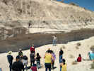
Field Trip Stop 7: Eastern Segment of Coaldale Fault (Volcanic Hills) in Lee, et al., 2006. Walk about 200 meters south of the dirt pullout.`
|
|
Other articles:
Junction: Nevada State Route 264, south through Fish Lake Valley. | Field Trip Stop 6 of Lee, et al., 2006 is one mile south on Nevada State Route 264.
|
Esmeralda County above
| Mineral County below
|
|
|
Literature Cited:
Other articles:
|
Grefco has operated this mine since 1944. J. S. Horton, Chief Mine Engineer of Grefco is quoted in Albers and Stewart (1972):
In 1989, mail came here from Mina, NV 89422, and the local telehone was Dicalite #1. The mine had 12 employees and produced 8,766 tons of diatomaceous earth. In 2007, the Basalt Mine and Mill had 9 employees and a telephone number: 775-573-2422. Mail was directed to Grefco's address in Burney, California.
|
|
|
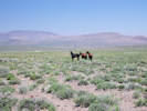
Other articles:
Wild horses in the field.
|
|
Other articles:
Locations: Basalt.
| BasaltJunction: Nevada State Route 360, north and east to US Highway 95.Populated place of Basalt to the south.
|
Other articles:
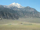
Locations: Mount Montgomery.
Mount Montgomery. Historical location, post office and station of the Southern Pacific narrow gauge.
|
|
Literature Cited:
Locations: Montgomery Pass.
| Montgomery Pass
|
Literature Cited:
Other articles:
Junction: Forest Road 01N155 | Turn off here onto Carson & Colorado roadbed for Field Trip Stop 5" Overview of Queen Valley and Middle Miocene Faulting in Lee, et al., 2006. Drive along the railroad grade about 1.6 miles and park along a wide pull-out before the old railroad bridge.
|
Literature Cited:
Field Trip Stop 4: Intersection of Queen Valley and Coaldale Faults, or Lee, et al., 2006. | About 1.2 miles west of Montgomery Pass, just east of the new highway bridge, park along the north side of the highway.
|
Other articles:
View of upper Queen Valley and the White Mountains to the southeast, and of Glass Mountain to the southwest across Queen Valley.
|
|
To the north of the highway are the claims belonging to the Montgomery Pass Project of the Homeland Precious Metals Corporation. This exploration is described as being within the Walker Lane golden corridor.
|
|
Other articles:
Locations: Hereford Valley Ranch.
Junction: Forest Road 1N135, east to Hereford Valley Ranch.
|
|
Locations:
Queen Valley.
This photo was taken from the Viewpoint.
|
|
Locations:
Boundary Peak.
Montgomery Peak.
This photo was taken from the Viewpoint. There are off-highway parking areas on both sides of the highway. Labelled as "Viewpoint" on the Truman Meadows USGS quadrangle map.
|
|
Literature Cited:
Other articles:
Locations: Queen Valley.
At 9.1 miles northeast of Benton, ranch on northwest side of highway.
| Junction
|
Nevada | California
|
Queen Valley above
| Benton Valley below
|
Literature Cited:
About 4 miles north of Benton, | Junction: Bramlette Ranch Road, then about 0.4 mile north on Bramlette Ranch Road, stop and climb to the top of the small hill to the east of the road. This is Field Trip Stop 2: Queen Valley Thrust Fault, of Lee, et al., 2006.
|
Other articles:
| Pedro Ranch Road, Forest Road 01S57. View of hills resulting from Queen Valley Thrust Fault.
|
Locations: Benton Valley.
Benton Valley
|
|
Literature Cited:
Other articles:
Locations: Benton.
| BentonJunction: California Highway 120, east to Lee Vining, and over Tioga Pass in Yosemite National Park.
|
Benton Valley above
| Hammil Valley below
|
Cross Marble Creek.
|
|
Cross Lone Tree Creek.
|
|
Hammil Valley above
| Chalfant Valley below
|
Other articles:
Locations:
Chalfant Valley.
Between Bishop and Benton, US Highway 6 passes through the Chalfant Valley, west of the White Mountains.
|
|
Literature Cited:
| Junction: White Mountain Estates Road Just to the east of the highway, above White Mountain Estates, Lifton, et al. (2021) studied Quaternary slip rates on the White Mountains Fault Zone. The total middle to late Pleistocene slip rate from the southern Walker Lane near 37.5°N was 7.9 + 1.3/0.6 mm/yr, ~75% of the observed modern geodetic rate.
|
Locations: Owens Valley.
Chalfant Valley above
| Mono County Inyo County Owens Valley below
|
Literature Cited:
Other articles:
Locations: Chalfant Quarry. Coldwater Canyon. Southern Belle Mine.
|
On the east side is:
On the west side is:
|
Other articles:
Junction: Jean Blanc Road, access to Fish Slough.
|
|
Other articles:
Locations:
Laws.
| LawsLocation of the Laws Railroad Museum. The Highway bypasses the town of Laws. To enter the town you must turn off at Silver Canyon Road.
|
Other articles:
Junction: Silver Canyon Road, turn here for the Laws Railroad Museum. | Also at this intersection is California Historical Landmark No. 230
|
Other articles:
Junction: 5 Bridges Road, north to Jean Blanc Road, in route to Fish Slough Road.
|
|
Other articles:
Locations: Bishop.
| BishopJunction: US Hwy 395This appears to be the end of US Hwy 6 in California. It has been replaced by California Highway 14, that begins in Inyokern, and ends at the junction with Interstate 5 in San Fernando.
If you have a question or a comment you may write to me at:
tas4@schweich.com
I sometimes post interesting questions in my FAQ, but I never disclose your full name or address.
|
|
Date and time this article was prepared: 4/14/2024 5:41:14 PM |