Eastern Mojave Vegetation
Tom Schweich
|
Eastern Mojave Vegetation
| Forest Road 1S160 (Former 1S437), Mono County, California |
|
Tom Schweich |

|
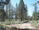
Roughly parallels upper Dry Creek. |
|
Literature Cited:
|
The Motorized Vehicle Restrictions map of Forest Order 04-07-01 (Inyo National Forest, 2007) designates this road as 01S437. The Motor Vehicle Use Map of 2010 (Inyo National Forest, 2010) identifies this road as 01S160. |
|
Other articles:
|
Junction: Forest Road 1N02, "Sagehen Meadows Road" |
|
Other articles:
|
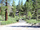
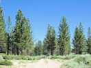
View south on 1S160 |
|
Other articles:
|
Cross a tributary of Dry Creek. |
| Junction: Forest Road 1S234, east to Sagehen Meadow Campground. | |
|
Other articles:
|
|
|
Other articles:
|
|
|
Adobe Valley drainage above
Mono Lake basin drainage below | |
|
Other articles:
|
Junction: Forest Road 1S161, north or east. |
|
Other articles:
Locations:
Mono Basin.
|
Entering Mono Lake basin, little canyon sloping away to right enters Dry Creek. |
|
Other articles:
|
Junction: Forest Road 1S160B, also designated 1S438 on some older maps. |
|
Other articles:
|
Junction: Forest Road 1S55 |
| If you have a question or a comment you may write to me at: tomas@schweich.com I sometimes post interesting questions in my FAQ, but I never disclose your full name or address. |
Date and time this article was prepared: 4/21/2025 8:15:12 PM |