Eastern Mojave Vegetation
|
Eastern Mojave Vegetation
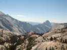
| Half Dome, Mariposa County, California. |
|
Gazetteer Query: G.N.I.S.
|
||
|
In Yosemite National Park, on the west wall of Little Yosemite Valley and 1.9 km (1.2 mi) north of Liberty Cap and the north bank of Merced River.
Articles that refer to this location:
| ||
| No collections made at this location. | ||
| If you have a question or a comment you may write to me at: tomas@schweich.com I sometimes post interesting questions in my FAQ, but I never disclose your full name or address. |
A, B, C,
D, E, F,
G, H, I,
J, K, L,
M, Date and time this article was prepared:8:31:46 PM, 4/21/2025. | |