Eastern Mojave Vegetation
Tom Schweich
|
Eastern Mojave Vegetation
| Fish Creek Wash, San Diego County, California |
|
Tom Schweich |

|
Through Split Mountain. | |
| Upper portion of wash | ||
|
Other articles:
|
Junction: Loop Wash Jeep Trail | |
|
Other articles:
|
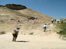
Field Trip Stop 3-7 Yuha Formation or member of Deguynos Formation. | |
|
Other articles:
|
Junction: Loop Wash Jeep Trail | |
|
Other articles:
|
Field Trip Stop 3-6 Colorado River delta rhythmites. | |
|
Other articles:
|
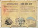
Field Trip Stop 3-5. Coyote Mountain Clays or Mud Hills member of the Deguynos Formation | |
|
Other articles:
|
Field Trip Stop 3-4. First evidence of the ancestral Colorado River. | |
|
Literature Cited:
Other articles:
|
| |
|
Literature Cited:
Locations: Split Mountain. |
Split MountainLate Miocene to early Pliocene deposits at Split Mountain Gorge, California, preserve a record of basinal response to changes in regional tectonics, paleogeography, and evolution of the Colorado River. The base of the Elephant Trees Formation, magnetostratigraphically dated as 8.1 ± 0.4 Ma, provides the earliest well-dated record of extension in the southwestern Salton Trough. The oldest marine sediments are ca. 6.3 Ma. The nearly synchronous timing of marine incursion in the Salton Trough and northern Gulf of California region supports a model for localization of Pacifi cNorth America plate motion in the Gulf ca. 6 Ma. The fi rst appearance of Colorado River sand at the Miocene-Pliocene boundary (5.33 Ma) suggests rapid propagation of the river to the Salton Trough, and supports a lake-spillover hypothesis for initiation of the lower Colorado River (Dorsey, et al., 2007, authors' abstract). | |
|
Other articles:
|
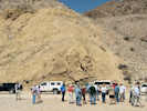
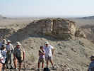
Field Trip Stop 3-2. Elephant Trees Conglomerate, "Red Rock," sturzstroms, and Split Mountain Anticline. | |
|
Other articles:
Locations:
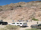
Fish Creek Campground.
|
Fish Creek Campground | |
|
Other articles:
|
Field Trip Stop 3-1. Fish Creek Gypsum, celestite, base of the Imperial Group, and Elephant Trees Conglomerate. | |
|
Other articles:
|
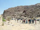
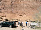
Junction: Split Mountain Road | |
| If you have a question or a comment you may write to me at: tas4@schweich.com I sometimes post interesting questions in my FAQ, but I never disclose your full name or address. |
Date and time this article was prepared: 5/10/2024 10:59:42 AM |