Eastern Mojave Vegetation
Tom Schweich
|
Eastern Mojave Vegetation
| California Highway 140 |
|
Tom Schweich |

|
(No Preface) |
|
Other articles:
|
Junction: California Highway 41, south to Wawona, or north to Crane Flat. |
| El Portal | |
|
Other articles:
|
|
|
Other articles:
|
|
|
Other articles:
Locations:
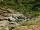
Bear Creek.
|
|
|
Other articles:
Locations:
Bear Creek.
|
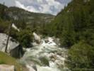
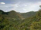
Going north from Mariposa, Highway 140 climbs over a low pass, and then descends along Stockton Creek, joining Bear Creek, to the Merced River. |
|
Other articles:
|
Junction: California Highway 49, north to Mt. Bullion and the rest of the Mother Lode. |
|
|
Mariposa |
|
Other articles:
|
Junction: California Highway 49, south to California Highway 41 at Oakhurst. |
|
Other articles:
|
Cunningham Road. |
|
Other articles:
|
Junction: California Highway 99, South |
|
Other articles:
|
Junction: California Highway 99, North |
|
Other articles:
|
Junction: US Interstate 5 |
| If you have a question or a comment you may write to me at: tas4@schweich.com I sometimes post interesting questions in my FAQ, but I never disclose your full name or address. |
Date and time this article was prepared: 4/14/2024 5:25:08 PM |