Eastern Mojave Vegetation
Tom Schweich
|
Eastern Mojave Vegetation
| Cerro Gordo Road |
|
Tom Schweich |

|
(No Preface) |
|
Other articles:
|
|
|
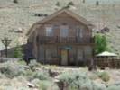
Locations: Cerro Gordo (Town). |
Cerro Gordo (Town) |
|
Other articles:
Locations:
Cerro Gordo (Town).
|
|
|
Locations:
Cerro Gordo (Town).
|
View of Cerro Gordo from the entrance to the town. |
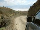
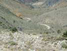
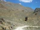
 Last Mile of Cerro Gordo Road. Last Mile of Cerro Gordo Road.
|
The last mile of the road is in the bottomof the canyon. |
|
Locations:
Cerro Gordo (Town).
|
|
|
Other articles:
|
|
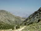
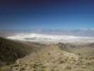
 View of Owens Lake and Keeler from the Cerro Gordo Road. View of Owens Lake and Keeler from the Cerro Gordo Road.
|
View point above the Sunset Mine. |
|
Locations:
Owens Lake.
|
|
|
Other articles:
|
|
|
Literature Cited:
|
Rocks along Cerro Gordo Road correlate with Jurrasic arc-marginal volcanogenic sedimentary rocks in the northeastern section of the Alabama Hills (Dunne and Walker, 1993). |
 Lower end of tramway at Cerro Gordo. Lower end of tramway at Cerro Gordo.
|
|
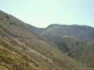
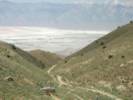
 Looking up the Cerro Gordo Road. Looking up the Cerro Gordo Road.
|
|
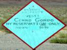 Sign at the bottom of the hill. Sign at the bottom of the hill.
|
|
|
Other articles:
|
Junction: California Highway 136 |
| If you have a question or a comment you may write to me at: tomas@schweich.com I sometimes post interesting questions in my FAQ, but I never disclose your full name or address. |
Date and time this article was prepared: 9/22/2024 4:37:16 PM |