Eastern Mojave Vegetation
Tom Schweich
|
Eastern Mojave Vegetation
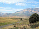
| Oil Plant Road, Mono County, California |
|
Tom Schweich |

|
West from US Highway 395 to nowhere ? | ||
|
Other articles:
|
Junction: US Highway 395 | ||
|
Other articles:
Letters:
Thursday, April 10, 2014.
|
| ||
|
Other articles:
Locations:
Reversed Peak.
|
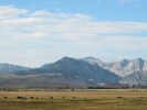
View of Reversed Peak, with San Joaquin Mountain in the distance. | ||
 Location of Farrington Ranch. Location of Farrington Ranch.
|
|||
|
Other articles:
Locations:
Farrington Ranch.
|
Junction: Old US Highway 395, south towards Cain Ranch. Approximate location of Farrington's. | ||
|
Other articles:
|
Junction:
| ||
| If you have a question or a comment you may write to me at: tomas@schweich.com I sometimes post interesting questions in my FAQ, but I never disclose your full name or address. |
Date and time this article was prepared: 7/13/2024 8:02:34 AM |