Eastern Mojave Vegetation
|
Eastern Mojave Vegetation
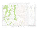
| Summerville Point, Emery County, Utah. |
|
Gazetteer Query: G.N.I.S. See also: Dry Mesa. San Rafael Swell. Summerville Wash.
|
||
|
Type locality of the Summerville Formation. See: Gilluly, James, and John B. Reeside, Jr. 1928, wherein the location is named without giving details as to its location. Many current publications refer to this location, such as the recent Draut (2005), but none give the location, referring instead to Gilluly and Reeside (1928).
The location is not listed in the Geographic Names Information System (GNIS). A protracted exchange of email with USGS data managers and librarians also ended at the Gilluly and Reeside (1928) paper, with no definitive location information. Two local sources have placed Summerville Point at the same location at the west edge of Dry Mesa. They are Dennis Udink of Udink.Org, and Gary Wulfenstein of SanRafaelSwell.Org. I read in his blog that Dennis Udink had visited Summerville Point, so I asked him where he thought Summerville point was, and received the following reply (Dennis Udink, pers. comm., 2008) "There's probably a [good] chance that I was at the exact type location for the Summerville Formation. It is definitely southwest of Woodside, on the west side of the Woodside Anticline near Summerville Wash. I studied the paper by Gilluly and Reeside and made an educated guess on where I thought Summerville Point is. "To determine where I thought Summerville Point was, I used the map on page 61 of the Gilluly/Reeside paper (specifically, the geographical relationship between Entrada, Summerville, and Curtis points), combined with the following description of the type locality from page 80: ". . .so named from its excellent exposures on Summerville Point, just southeast of the head of Summerville Wash . . ." There are two prominent and well-exposed outcrops of Summerville Formation just southeast of the head of the Middle Fork of Summerville Wash (as the current USGS map calls it), and I chose the most prominent-looking one (when viewed from the west). It also happened to be the easiest to access. The other point that I had considered is about 0.8 miles north of the point I actually visited. "The coordinates for the place I visited (in WGS 84 format) are N 39° 10.903' W 110° 27.831'. Here is a Google Maps link to that location: http://maps.google.com/maps?ie=UTF8&ll=39.181599,-110.463678&spn=0.005189,0.006716&t=h&z=17 San Rafael Swell (http://www.sanrafaelswell.org) has many photos and other information useful in planning a visit to the area. In response to my query, I received the following reply: "Our information places Summerville Point at or about 39.183335° -110.463349°. At least it is on this ridge. Access to the ridge can be found from a spur off the cut off road on Dry Mesa. This is a rough ATV road but well worth the view to be had (Gary Wulfenstein, pers. comm., 2008)" The two locations are on the same ridge, within 640 feet of each other. Two independent sources giving essentially the same place gives one confidence in the location of the place. It would be better if the place could be found on an old map or in another written description from the time the type locality was designated (1928). However, the information we have seems pretty reliable.
Articles that refer to this location:
Literature Referring To This Location:
| ||
| No collections made at this location. | ||
| If you have a question or a comment you may write to me at: tomas@schweich.com I sometimes post interesting questions in my FAQ, but I never disclose your full name or address. |
A, B, C,
D, E, F,
G, H, I,
J, K, L,
M, Date and time this article was prepared:8:15:57 AM, 7/13/2024. | |