Eastern Mojave Vegetation
Tom Schweich
|
Eastern Mojave Vegetation
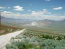
| Dirt Road to East of Fairview Peak, Churchill County, Nevada |
|
Tom Schweich |

|
(No Preface) | ||
|
Other articles:
|
Junction: U. S. Highway 50 | ||
|
Literature Cited:
Other articles:
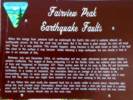
Locations: Fairview Peak. |
This is Stop 3, Overview of Fairview Peak - Dixie Valley rupture sequence, of | ||
|
Other articles:
Locations:
Fairview Peak.
|
|||
|
Literature Cited:
Other articles:
Locations: Fairview Peak. |
This is Stop 4, "Main scarp of the Fairview Peak rupture" of Caskey, Bell, and Slemmons (2000), p. 31. See also Caskey, et al., 2004. | ||
|
7.2 miles south of US Highway 50. This is Stop 4, "Compound scarp in northern Bell Flat," of Caskey, Bell, and Slemmons (2000). | |||
| If you have a question or a comment you may write to me at: tomas@schweich.com I sometimes post interesting questions in my FAQ, but I never disclose your full name or address. |
Date and time this article was prepared: 9/22/2024 4:46:58 PM |