Eastern Mojave Vegetation
Tom Schweich
|
Eastern Mojave Vegetation
| US Highway 64 |
|
Tom Schweich |

|
From Teec Nos Pos, Arizona, to Nags Head, North Carolina | ||||||||||||||||||||||||||||||||||||||||||||||||||||||||||
|
Other articles:
|
Teec Nos PosJunction: US Highway 160
|
Arizona above
| New Mexico below
|
Literature Cited:
Other articles:
Locations: Beclabito.
| BeclabitoFrasera albomarginata has been collected about 1 1/2 miles north of Beclabito.
|
Other articles:
Junction: US Highway 491, in Shiprock. The highways travel concurrently through Shiprock.
|
|
Other articles:
| ShiprockJunction: US Highway 491 North
|
| Farmington
|
Other articles:
Junction: US Highway 550, south, in Bloomfield. The highways travel comcurrently through Bloomfield.
|
|
Locations: Bloomfield.
| Bloomfield
|
Other articles:
Junction: US Highway 550, "N. 1st Street", north.
|
|
Locations: Potter Canyon.
Junction: |
Taking Rd 4800, then Rd 4903 gives access to Potter Canyon,which may also be a location of Frasera albomarginata.
|
Cross Potter Canyon wash.
|
|
| Blanco
|
Other articles:
Junction: US Highway 84, east of Monero. The highways travel concurrently to south-southwest of Tierra Amarilla.
|
|
Other articles:
Junction: NM Highway 17, north to Chama, and then into the San Luis Valley as Colorado State Highway 17.
|
|
Other articles:
Junction: US Highway 84, south of Tierra Amarilla, continuing south to Abiquiu
|
|
Other articles:
Junction: US Highway 285, in Tres Piedras.
|
|
Other articles:
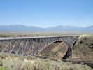
Locations:
Rio Grande.
Rio Grande Gorge Bridge.
|
|
Other articles:
Junction: Paseo Del Pueblo Norte, north to Taos Pueblo.
|
|
Other articles:
Junction:
|
|
Other articles:
Locations: Taos.
| Taos
|
Other articles:
Junction: US Interstate 25, US Highway 85, south of Raton. The highways travel concurrently to Raton.
|
|
Junction: US Interstate 25, US Highway 85, US Highway 87, in Raton. US 64/US 87 travel concurrently to Clayton.
|
|
Junction: US Highway 56, US Highway 87, US Highway 412, in Clayton. US 56/US 64 travel concurrently yo east-northeast of Boise City, Oklahoma. US 64/US 412 travel concurrently to Guymon.
|
|
New Mexico above
| Oklahoma below
|
Oklahoma above
| Arkansas below
|
Arkansas above
| Tennessee below
|
Tennessee above
| North Carolina below
|
Junction: US Highway 158, in Nags Head.
|
If you have a question or a comment you may write to me at:
tomas@schweich.com
I sometimes post interesting questions in my FAQ, but I never disclose your full name or address.
|
|
Date and time this article was prepared: 7/13/2024 8:14:04 AM |