Eastern Mojave Vegetation
Tom Schweich
|
Eastern Mojave Vegetation
| Utah Highway 59 |
|
Tom Schweich |

|
(No Preface) | ||
|
Other articles:
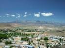
Locations: Hurricane. |
HurricaneJunction: Utah Highway 9,
| ||
|
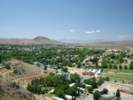
Other articles:
Locations:
Hurricane.
Hurricane Cliffs.
La Verkin.
|
| ||
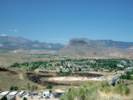
| Big Plain Junction | |||
|
Literature Cited:
Locations: Vermilion Cliffs. |
Vermilion Cliffs. | ||
|
Other articles:
Locations: Canaan Mountain. |
Canaan Mountain to the northeast. Frasera albomarginata has been collected on the lower slopes. | ||
|
Other articles:
|
Utah above Arizona below. Junction: Arizona Highway 389, east through Pipe Springs to Fredonia, Arizona. At Fredonia, Arizona, US Highway 89A goes north to US Highway 89 at Kanab, Utah, or south to Jacob Lake for access to the north rim of Grand Canyon, or continuing east past the Vermillion Cliffs to Marble Canyon and US Highway 89 at Bitter Springs, Arizona. | ||
| If you have a question or a comment you may write to me at: tomas@schweich.com I sometimes post interesting questions in my FAQ, but I never disclose your full name or address. |
Date and time this article was prepared: 9/22/2024 4:49:13 PM |