
|
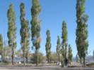
Cemetery Road in Mono County is on the northwest shore of Mono Lake. It runs from US Highway 395, past the Mono Lake County Park and the Mono Lake Cemetary, then north of Black Point and Dechambeau Ranch where it meets California Highway 167.
|
|
Other articles:
• U. S. Highway 395:
at Cemetery Rd;
|
Junction: US Highway 395, south to Lee Vining, or north to Bridgeport, Reno Nevada, etc.
|
|
Other articles:
• Mono Lake Basin Flora:
at Dechambeau Ck;
Locations:
Dechambeau Creek.
|
Dechambeau Creek
|
|
Other articles:
• Field Notes:
24-Jun-2007;
22 Jul 2013;
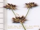
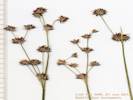
Coll. No. 1010;
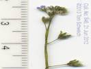
Coll. No. 1011;
Coll. No. 1012;
• Mono Lake Basin Flora:
at Dechambeau Ck;
Locations:
Thompson Ranch.
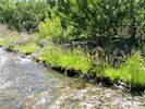
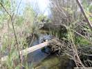
 A still functioning irrigation ditch in the former Thompson Ranch A still functioning irrigation ditch in the former Thompson Ranch
|
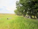
A still functioning irrigation ditch in the former Thompson Ranch |
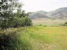
Thompson Ranch north of Mono Lake County Park |
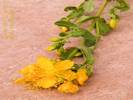
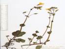
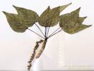
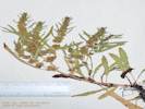
Coll. No. 1011, Hypericum scouleri |
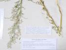
Coll. No. 1012, Chenopodium leptophylum |
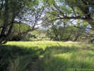
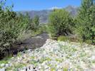
Above the county park are some large trees in a meadow. The area is signed as private property of Los Angeles Department of Water and Power. I had thought that this was Mono Vista Spring. However, tomorrow at the Mono Historical Museum, I would learn that this was the location of the Thompson Ranch house. Regardless, this was only a pleasant partially shaded meadow.
Two interesting collections from Thompson Ranch have been Myosotis laxa, the Bay Forget-Me-Not, which I think is a recent introduction to the Mono Lake Basin, and Hypericum scouleri, Scouler's Gold Wire. These were made along a former irrigation ditch which seems to still function. In a drier part of the meadow, I collected Chenopodium lentophylum, Narrowleaf Goosefoot.
|
|
Other articles:
• Field Notes:
23 Sep 2006;
• Mono Lake Basin Flora:
at County Park;
Locations:
Mono Lake.
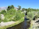
Mono Lake County Park.
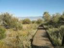 Boardwalk to Mono Lake shore at Mono Lake County Park. Boardwalk to Mono Lake shore at Mono Lake County Park.
|
Mono Lake County Park.
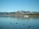
Mono Lake at Mono Lake County Park on north shore. |
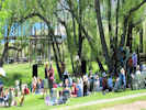
Concert in Mono Lake County Park at conclusion of the 2010 Chautauqua. |
Board walk to Mono Lake shore and tufa.
|
|
Other articles:
• Field Notes:
23 Sep 2006;
Locations:
Mono Lake Cemetery.
 Mono Lake Cemetery Mono Lake Cemetery
|
Mono Lake Cemetery
|
|
Other articles:
• Field Notes:
Coll. No. 845;
Coll. No. 846;
Coll. No. 847;
Coll. No. 848;
Coll. No. 849;
Coll. No. 977;
• Mono Lake Basin Flora:
at Mill Creek;
Locations:
Mill Creek.
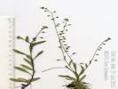
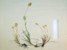
 Coll. No. 845, Juncus macrandrus Coll. No. 845, Juncus macrandrus
|
Coll. No. 845, Juncus macrandrus |
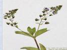
Coll. No. 846, Myosotis laxa |
Coll. No. 846, Myosotis laxa |
Coll. No. 847, Erythranthe utahensis |
Coll. No. 848, Epilobium ciliatum var. ciliatum |
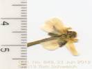
Coll. No. 849, Ranunculus aquatilis var. diffusus |
Coll. No. 977, Populus trichocarpa |
A few plants collected along Mill Creek above Cemetery Road.
|
|
Other articles:
• Field Notes:
Coll. No. 1005;
Coll. No. 1006;
Coll. No. 1007;
Coll. No. 1008;
Coll. No. 1009;
• Mono Lake Basin Flora:
at Mill Creek;
Locations:
Mill Creek.
 Habitat of Coll. No. 1006, Myosotis laxa Habitat of Coll. No. 1006, Myosotis laxa
|
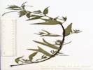
Coll. No. 1007, Polypogon monspeliensis |
Coll. No. 1005, Veronica anagallis-aquatica |
Coll. No. 1009, Rumex triangulivalvis |
Coll. No. 848, Epilobium ciliatum var. ciliatum |
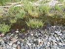
I have had the best success following the west side of Mill Creek when hiking down to the delta of the creek at Mono Lake. Here are some of the plants found there:
|
|
Other articles:
• Field Notes:
21 Jun 2012;
21 Jun 2012;
• Mono Lake Basin Flora:
at Mill Creek;
Locations:
Mill Creek.
 Mill Creek just below Cemetery Road Mill Creek just below Cemetery Road
|
Mill Creek above Cemetery Road. |
Mill Creek above Cemetery Road. |
Mill Creek
|
|
Literature Cited:
- Bridge, John, and Robert Demicco, 2008.
Other articles:
• Racetrack Valley Road:
Ubehebe Crater;
• Field Notes:
20090708040;
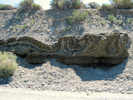 Deformed sediments near Mill Creek Deformed sediments near Mill Creek
|
This popular geology field trip location is an example of soft sediment deformation of late Pleistocene - Holocene lake sediments, probably triggered by seismic shock.
Here are some links to places where this example was used. Some of the links may break as time goes by.
|
|
Other articles:
• Field Notes:
23 Sep 2006;
• Mono Lake Basin Flora:
at Mill Creek;
Locations:
Mill Creek.
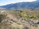 Mill Creek near Mono Lake. Mill Creek near Mono Lake.
|
View of Mill Creek
|
|
|
Wilson Creek
|
|
Other articles:
• Black Point Rd. (FR 02N42):
at Cemetery Rd;
Locations:
Wilson Creek.
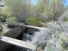 Weir on Wilson Creek. Weir on Wilson Creek.
|
Gate to the DeChambeau irrigation ditch |
Junction: Forest Road 02N42 “Black Point Road”, to Black Point and Dechambeau Ranch.
|
|
|
Dechambeau Ranch
|
|
Other articles:
• Forest Road 02N20:
37000;
|
Junction: Forest Road 02N20 “Dechambeau Ranch Q-005” Road through Dechambeau Ranch
|
|
Other articles:
• Forest Road 02N19:
at 02N43N;
• Forest Road 02N43 “Dechambeau Hot Springs”:
at Cemetery Rd;
|
Junction: Forest Road 02N43 “Dechambeau Hot Springs”
Also a very short distance down F. R. 02N43 is the junction with F. R. 02N19, the road to Dechambeau Ponds.
|
|
Other articles:
• California Highway 167:
at Cemetery Rd;
|
Junction: California Highway 167, west to US Highway 395, or east to Bodie, the Nevada state line, and other points east of Mono Lake.
|
|
If you have a question or a comment you may write to me at:
tas4@schweich.com
I sometimes post interesting questions in my FAQ, but I never disclose your full name or address.
|
[Home Page] [Site Map]
Date and time this article was prepared:
4/27/2024 3:16:40 PM
|
 Eastern Mojave Vegetation