Eastern Mojave Vegetation
Tom Schweich
|
Eastern Mojave Vegetation
| New Mexico State Road 161 |
|
Tom Schweich |

Topics in this Article: Literature Cited |
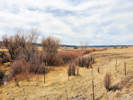
State Road 161 (NM 161) is a 31.902-mile-long (51.341 km) state highway in northeastern New Mexico. NM 161 begins in the west at its junction with NM 518 several miles south of the unincorporated community of La Cueva. The road travels southeast through remote, sparsely populated land before reaching a junction with Interstate 25 (I-25) south of Watrous. From there, the road turns northeast and briefly parallels I-25 before cutting back to the northwest, where it intersects I-25 again, then continues north for roughly seven miles before terminating at Fort Union National Monument. Shortly before reaching Fort Union, NM 161 crosses the former path of the Santa Fe Trail which is still visible as a broad, shallow ditch or low spot in the terrain. | ||||
|
|
Buena VistaJunction: New Mexico State Road 518 | ||||
|
Other articles:
|
Junction: US Interstate 25 | ||||
|
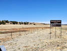
Locations: Watrous. |
Watrous | ||||
|
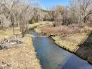
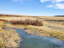
Cross Sapello River | |||||
|
Other articles:
Locations:
Mora River.
|
Cross Mora River | ||||
|
Other articles:
|
Junction: US Interstate 25 | ||||
|
Other articles:
|
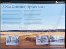
Wagon ruts interpretive panels.
| ||||
|
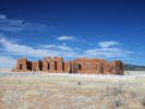
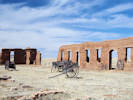
View of Fort Union | |||||
|
Other articles:
Locations:
Wolf Creek.
|
Cross Wolf Creek
| ||||
|
Other articles:
Locations:
Fort Union.
|
Fort Union National Monument
| ||||
|
|
Literature CitedA list of all literature cited by this web site can be found in the Bibliography. | ||||
| If you have a question or a comment you may write to me at: tas4@schweich.com I sometimes post interesting questions in my FAQ, but I never disclose your full name or address. |
Date and time this article was prepared: 4/27/2024 3:28:31 PM |
||||