Eastern Mojave Vegetation
Tom Schweich
|
Eastern Mojave Vegetation
| California Highway 168 |
|
Tom Schweich |

|
There are three distinct segments of California Highway 168. The first segment goes from CA Hwy 180 in Fresno to Huntington Lake. The second segment goes from Lake Sabrina to US Hwy 395 in Bishop. The third segment of California Highway 168 runs from U. S. Highway 395 at Big Pine, through Westgard Pass between the Inyo Mountains and the White Mountains, through Deep Springs Valley to Oasis on the California - Nevada border. | |||||||||||||||||||||||||||||||||||||||||||||||||||||||
|
Other articles:
|
Junction: California Highway 180 | |||||||||||||||||||||||||||||||||||||||||||||||||||||||
|
|
Huntington Lake | |||||||||||||||||||||||||||||||||||||||||||||||||||||||
|
| ||||||||||||||||||||||||||||||||||||||||||||||||||||||||
|
Locations: Lake Sabrina. |
Lake Sabrina | |||||||||||||||||||||||||||||||||||||||||||||||||||||||
|
Locations: Bishop Creek. |
||||||||||||||||||||||||||||||||||||||||||||||||||||||||
|
Other articles:
|
Junction: North Lake Road
|
|
Other articles:
Junction: US Highway 395
|
|
|
|
Other articles:
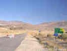
Locations: Big Pine.
| Big PineJunction: US Highway 395, south to Lone Pine, Ridgecrest, and the wilderness of Los Angeles; or north to Bishop, Mammoth Lakes, Mono Lake, Reno, etc.
|
Literature Cited:
Other articles:
|
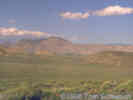
Field Trip Stop 3-1 of the 2009 Desert Symposium (Reynolds and Jessey, 2009). The biostratigraphic sequence to the east along Hwy 168 near Westgard Pass contains some of the oldest rock units in western North America. These Precambrian and Cambrian rock units contain an abundant Lower to Middle Cambrian fauna, including Archeocyathids, trilobites, Scolithus (worm burrows) and Girvanella algal structures. The trilobite Fallotaspis in the shales of the Campito Formation marks the Cambrian-Precambrian boundary. These trilobites are older than those from the Carrara Shale at Emigrant Pass east of Shoshone and those in the Latham Shale of the southern Marble Mountains. Because of the abundance of fossil fauna and tectonic history of the region, the Westgard Pass vicinity is a favorite location for geology summer field camps.
|
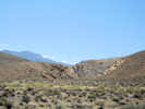
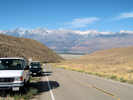 Canyon ascending to Westgard Pass Canyon ascending to Westgard Pass
Field trip stop in CA Hwy 168.
|
|
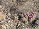 Echinocereus engelmannii Echinocereus engelmannii
Hedgehog Cactus (Echinocereus engelmannii) on terrace along side wash.
|
|
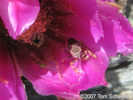 Bug in Echinocereus engelmannii Bug in Echinocereus engelmannii
This flower was inhabited by a bug.
|
|
Other articles:
Locations: White Mountains.
Junction: White Mountain Road
|
|
Literature Cited:
Locations:
Westgard Pass.
| Westgard Pass
|
Locations: Mollie Gibson Canyon.
| Mollie Gibson Canyon
|
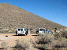
 Geology field trip at an interesting outcrop. Geology field trip at an interesting outcrop.
The vans for a probable geology field trip parked across Highway 168.
|
|
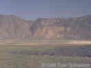
Locations:
Deep Springs Valley.
| Deep Springs Valley
|
Literature Cited:
Locations: Deep Springs Dunes.
Deep Springs Dunes.
| It's not clear to me where these dunes are. Pavlik's (1985) published location of 37°35'N, 118°05'W is on the eastern flank of the White Mountains, about 17 miles north of Deep Springs Valley. If Pavlik meant 37.35°N, 118.05°W, the location is in a small hanging valley at the mouth of Birch Creek, but still in coarse alluvium on the very northern edge of Deep Springs Valley. I would assume the dunes would be on the southeast margin of the valley, downwind of Deep Springs Lake.
|
Birch Creek.
|
|
Literature Cited:
Locations: Beer Creek.
Beer Creek.
| Two locations of the contact aureole between the Eureka Valley - Joshua Flats - Beer Creek pluton and the surrounding paleozoic sediments are found in the canyon of Beer Creek. There is a road going north into the mouth of Beer Creek from CA Highway 168 and, a little to the east, is another road that approaches the mouth of Beer Creek from the east. There is no road into the canyon of Beer Creek from the mouth. The Beer Creek (ca. 179 Ma), Sage Hen Flat (ca. 175 Ma), and Redding Canyon (ca. 164 Ma) plutons all intrude variably deformed Paleozoic strata, but are themselves undeformed (Coleman, et al., 2003).
|
| Deep Springs College
|
Locations: Wyman Creek.
Deep Springs Highway Maintenance Station, cross Wyman Creek
|
|
Road north to Wyman Canyon.
|
|
Road west to Wyman Canyon.
|
|
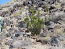 The rare, and perhaps only, Creosote Bush in the White Mountains. The rare, and perhaps only, Creosote Bush in the White Mountains.
On a basalt outcrop is found what may be the only Creosote Bush in the White Mountains.
|
|
Locations:
Wyman Canyon.
View into "Wyman Canyon" from basalt outcrop near CA Highway 169. "Wyman Canyon" is a name commonly applied to the canyon containing Wyman Creek. However, it is not recognized by the GNIS.
|
|
Literature Cited:
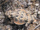
Southern Desert Horned Lizard (Phrynosoma platyrhinos) seen at Gilbert Pass.
|
|
Literature Cited:
Locations:
Gilbert Pass.
| Gilbert PassElevation: 6375 ft.The sign states this is "Gilbert Summit." However, the U. S. Board of Geographic Names has designated this as Gilbert Pass. Road southwest into the canyon between Chocolate Mountain (Piper Peak) and Sugarloaf Mountain. This canyon is a location for investigation of the contact aureole between the Eureka Valley - Joshua Flats - Beer Creek pluton and the host paleozoic sedimentary rocks (Nabelek and Swenson, 2012, and others).
|
Inyo County above
| Mono County below
|
Other articles:
| Oasis
|
Other articles:
Junction: Nevada Highway 266, east past Magruder Mountain and Lida to Lida Junction at U. S. Highway 95.
|
If you have a question or a comment you may write to me at:
tomas@schweich.com
I sometimes post interesting questions in my FAQ, but I never disclose your full name or address.
|
|
Date and time this article was prepared: 7/13/2024 8:01:27 AM |