
Topics in this Article:
1996
2006
2007
2008
2009
Literature Cited
|
This is just a collection of maps I have drawn.
|
|
|
1996
|
|
Other articles:
• Field Notes:
28 Nov 2009;
• Maps:
in December 2006;
Locations:
Lobo Point.
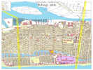
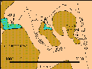 Location of Lobo Point. Location of Lobo Point.
|
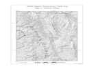
1 January 1996
This map, showing the location of Lobo Point, was probably prepared on January 1, 1996, using Micrografx Designer.
|
|
|
2006
|
|
Other articles:
• Field Notes:
28 Nov 2009;
• Maps:
in January 1996;
in August 2008;
Locations:
Lobo Point.
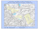
 Location of Lobo Point. Location of Lobo Point.
|
18 December 2006
This is a early ArcGIS map showing the location of Lobo Point.
|
|
|
2007
|
|
Other articles:
• Mono Lake Basin Flora:
Floristic Research in Nearby Areas;
Locations:
Mono Basin.
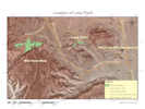
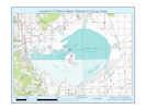
 Mono Basin and other nearby areas with floristic research Mono Basin and other nearby areas with floristic research
|
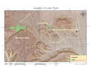
9 October 2007
This map is intended to show areas near the Mono Lake Basin where other floristic research has been done.All of the data came from the ESRI Maps & Data DVD.
|
|
|
2008
|
|
Locations:
Mid Hills.
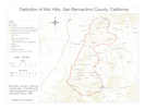 Base map showing location of Mid Hills, San Bernardino County, California Base map showing location of Mid Hills, San Bernardino County, California
|
Definition of the Mid Hills
|
|
Other articles:
• Field Notes:
28 Nov 2009;
• Maps:
in December 2006;
Locations:
Lobo Point.
 Location of Lobo Point. Location of Lobo Point.
|
3 August 2008
This is the current (November 2009) showing the location of Lobo Point
|
|
|
2009
|
|
Literature Cited:
- Reynolds, Robert E., and David R. Jessey, 2009.
Other articles:
• Garlock Road:
at Charley Rd;
• California Highway 136:
near Swansea;
bet. Swansea and Keeler;
at Cerro Gordo Rd;
• California Highway 14:
in Red Rock Cyn;
• California Highway 168:
at Death Valley Road;
• Dolomite Road:
at Mine Access Road;
• Fish Slough Road:
Fish Slough;
• Fish Springs Road:
along Fish Sprs Rd;
• Forest Road 2S07:
Hot Creek Recreation Site;
• Forest Road 3S07:
at Blue Chert Mine;
• Owenyo - Lone Pine Road:
50000;
• Tinemaha Road:
Poverty Hills;
• Whitmore Tubs Road:
at Stop 2-10;
• Whitney Portal Road:
20000;
at access road;
• Antelope Springs Road:
along the road;
at Huntley Kaolinite Quarry;
• U. S. Highway 395:
at Big Pumice Cut;
s. of Volcanic Tableland;
at Miller St;
near Cottonwood Charcoal Kilns;
at Coso Junction;
at Little Lake Rd;
• U. S. Highway 6:
at Rudolph Rd;
Locations:
Fish Slough.
Long Valley.
Owens Valley.
|
2009 Desert Symposium Field Trip
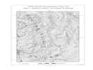
Field Trip Day 1 |
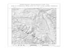
Field Trip Day 2 |
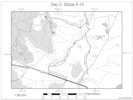
Field Trip Day 2, Detail of Stops 5-10 |
Field Trip Day 3 |
This series of maps was prepared for the field trip of the 2009 Desert Symposium.
The complete proceedings including the field trip road log can be obtained (November 2009) at:
http://biology.fullerton.edu/dsc/pdf/2009landscapeevolution.pdf
.
The coordinate system used in this map is USA_Contiguous_Equidistant_Conic, with a central meridian of -118.5°, the approximate center line of this series of maps. The geographic system is GCS_North_American_1983.
All of the data is originally WGS1984, and is stored that way in the data base.
The map is designed to be reproduced in black and white, and was delivered to
the publisher as a TIFF file.
The layers in this map are.:
- XYtblStopAnnoDay. Annotation for the field trip stops. Ended up with an annotation file for each day. Derived from labels of feature class XYtblStop.
- DS09AnnotationDay. Annotation for the map. An annotation file for each day's map. Shows location and physical feature data, such as "Sierra Nevada," and "Long Valley."
- ParksDetailAnno. Names of national and state parks.
- MRoadsAnno. Numbers of state and national highways, and interstates, shown in standard shields.
- XYtblGNISMonoCty. Derived from the GNIS, intended to show locations in Mono County, but whittled down several times until only Glass Mountain remained, and used only in the map for Day 2.
- XYtblStop. Started life as an Excel spreadsheet with the geographic coordinates of the field trip stops. Then created a feature class from XY table.
- CitiesDetail. Locations of towns and cities. Not labelled.
- Route20081108. Route of the field trip. Assembled from Mroads and Streets. Displayed twice on the maps, once in white underneath the roads, and once in black above the roads.
- Faults_Merge_CA_NV. Orignally intended to show major faults in California and Nevada, but whittled down until only the location of the Long Valley ring fault is shown. I don't distinguish between visible, hidden or inferred faults on my map.
- Mroads. Source: ESRI Data & Maps DVD. Source data for most road son the map.
- Streets. Source: ESRI Data & Maps DVD. Used on the detail for Day 2 to show the smaller roads.
- ParksDetail. Source: ESRI Data & Maps DVD. State and national parks, data a little obsolete.
- Water. Source: ESRI Data & Maps DVD. Many small features deleted.
- Rivers. ESRI Data & Maps DVD. Shown on the detail map for Day 2 Stops 5-10.
- States. ESRI Data & Maps DVD. State boundaries for California and Nevada.
- TopoQ24. Identifies the 7.5" topo maps covering the area in the map. Used when preparing the maps to compare my data and field trip stop data with features shown on the USGS quadrangles.
- shadedrelief. Source: ESRI Data & Maps DVD. Forms the backdrop for the maps.
- ned_77626690. National Elevation Dataset. Used only in the detail map for day 2. Symbology shows elevations greater than 1930 m as gray, while lower elevations are white. This approximates the distribution of Jeffrey pine vegetation.
|
|
 Map for Alameda CERT Exercise Map for Alameda CERT Exercise
|
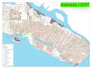
22 September 2009
This map was requested by the team planning an Alameda CERT exercise on October 3, 2009. The exercise simulates a neighborhood size-up following an earthquake. A Command Post will be set up and teams will be deployed as they would be to size-up a neighborhood using FRS radios for communications. The scale of this drill covers a large area on Bay Farm and we need as many CERT volunteers as possible to assess the damage. At the same time, we will be distributing important Preparedness Information to the neighborhood.
|
|
Locations:
Alameda.
 Map of the Main Island Map of the Main Island
|
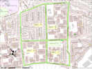
23 September 2009
This map was requested by a member of the Executive Committee to show to new CERT trainees and determine whether they lived in a neighborhood with a team, or where the nearest team is located.
The map also shows how much of the main island can be gotten onto a single ANSI E-size sheet, using a scale of 1:6000.
|
|
Locations:
Alameda County.
Contra Costa County.
Napa County.
Solano County.
 ARRL East Bay Section ARES Map ARRL East Bay Section ARES Map
|
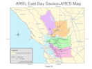
6 October 2009
This map was requested by my local ARES coordinator to show the extent of the American Radio Relay League (ARRL) East Bay section of Amateur Radio Emergency Services (ARES).
The data source is a combination of county divisions from Cal-Atlas (http://www.atlas.ca.gov/) and the ArcGIS Data & Maps 9.3 DVD.
|
|
 Central Portion of Alameda Central Portion of Alameda
|
31 October 2009
This map is one of a series of maps prepared for use in the city Emergency Operations Center.The full size map is at:
http://www.schweich.com/images/AlamedaESizeMap420091002sm.pdf
The source data is a combination of:
- City of Alameda GIS Data
- Basemap
- Fire Appurtenance
- Utilities
- Police
- Road Appurtenance
- Water Features
- Alameda Additions by me.
- Basemap
- Tiled Map Boundaries.
Guides users to the correct map for an area of interest.
- Pavement Additions.
Small, but significant, areas of pavement missing from the city GIS data. Primarily paved areas around the College of Alameda, a shelter site, and paved areas around the Peets plant, a planned location for storage of a Mobile Disaster Unit (MDU).
- Pseudo-Parcels.
There are some important facilities that are not located on defined parcels. This is especially true at Alameda Point (the former naval air station), which is composed of just two parcels. Pseudo-Parcels were defined to highlight the locations of fire stations, fire training facilities, and Red Cross facilities where no parcels are defined.
- Fire Appurtenance
- Building Additions.
Primarily the Peets plant and the new Alameda Free Library.
- Evacuation Area Boundaries.
- Fire Symbol Additions.
Contains ball fields and tennis courts. These were included in the city GIS data, but the location and orientation were not sufficiently accurate.
- Road Appurtenance
- Path Additions
- Street Bridges.
In the city GIS data, bridges are visible only as EdgeOfPavement lines extending over water. This feature class makes the bridge appear as a solid object over the water.
- Pedestrian Bridges.
In the city GIS data, pedestrian bridges are visible only as lines representing the edges of paths extending over water. This feature class makes the pedestrian bridges appear as a solid objects over the water. Most of the pedestrian bridges cross the lagoons in Harbor Bay. The exception is the bicycle bridge from the main island to Bay Farm Island.
- Airport (former Naval Air Station Alameda).
Runways as polygons. Edges of runways, taxiways, and aprons as lines. Approximate. Intended only to suggest the configuration of paving in what would otherwise appear to be an empty quarter.
- Water Features
- Facility Type table.
Associates a land use with a Parcel or Pseudo-Parcel. Used to indentify city buildings, schools, fire stations, other critical facilities, etc.
- ESRI Data and Maps DVD Version 9.3.1
- Basemap
- Streetscarto. Highways and streets outside the city of Alameda.
- Water Features
- Waterp. Additional areas of water, outside the extent of the city GIS data.
|
|
Other articles:
• Mono Lake Basin Flora:
Mono Basin Research Group;
Locations:
Mono Basin.
 Location of Mono Basin Research Group sites. Location of Mono Basin Research Group sites.
|
|
|
|
Literature Cited
A list of all literature cited by this web site can be found in the Bibliography.
|
| |
Reynolds, Robert E., and David R. Jessey. 2009.
Landscape Evolution at an Active Plate Margin.
The 2009 Desert Symposium Field Guide and Proceedings.
Fullerton and Riverside, Ca: Desert Studies Consortium, California State University and LSA Associates, Inc., April 2009.
{TAS}
|
|
If you have a question or a comment you may write to me at:
tas4@schweich.com
I sometimes post interesting questions in my FAQ, but I never disclose your full name or address.
|
[Home Page] [Site Map]
Date and time this article was prepared:
4/14/2024 5:38:34 PM
|
 Eastern Mojave Vegetation