Eastern Mojave Vegetation
Tom Schweich
|
Eastern Mojave Vegetation
| California Highway 270 |
|
Tom Schweich |
Topics in this Article: Cinnabar Canyon |
California Highway 270 (SR 270), also known as Bodie Road, is a state highway in the U.S. state of California.
It is a spur route off of U.S. Route 395 south of Bridgeport in Mono County, leading into Bodie State Historic Park.
The route connects U.S. Route 395 with Bodie State Historic Park. About 3.5 miles (5.6 km) before entering the park, the road becomes unpaved, and is maintained by the California Department of Parks and Recreation (California State Parks) instead of being officially part of the state highway system maintained by Caltrans. SR 270 is not part of the National Highway System, a network of highways that are considered essential to the country's economy, defense, and mobility by the Federal Highway Administration. |
||
|
Other articles:
|
Junction: US Highway 395 | ||
| California Highway 270 follows Clearwater Creek | |||
|
Literature Cited:
Other articles:
Locations: Big Alkali. Cinnabar Canyon. |
Cinnabar Canyon
| ||
|
Other articles:
|
| ||
|
Other articles:
|
| ||
|
Other articles:
|
| ||
|
Literature Cited:
Other articles:
Locations: Mormon Meadow. |
Mormon Meadow
| ||
| Mormon Ranch | |||
|
Other articles:
|
| ||
|
Other articles:
|
| ||
|
Literature Cited:
Locations: Mount Biedeman. |
Mount Biedeman is within the area covered by Messick's (1982) flora of the Bodie Hills. | ||
|
Other articles:
|
Junction: Unknown Road, into uppermost Cottonwood Canyon drainage. | ||
|
Locations: Mono Basin. |
Clearwater Creek (East Walker River) Basin above … Pass Mono Lake basin (Cottonwood Canyon) below … | ||
|
Other articles:
|
| ||
|
Other articles:
|
| ||
|
Other articles:
|
| ||
|
Other articles:
|
| ||
|
Literature Cited:
Other articles:
Locations: Murphy Spring. |
Murphy Spring
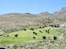
While Annie Alexander and Louise collected here, this trip it was full of cows and not very inviting for botanizing. | ||
|
Other articles:
|
| ||
|
Other articles:
|
| ||
|
Locations: Mono Basin. |
Mono Lake basin (Cottonwood Canyon) above … Pass Rough Creek (East Walker River) Basin below … | ||
|
Other articles:
|
Junction: Cottonwood Canyon Road | ||
| Bodie State Historic Park entrance station. | |||
| Bypass Road | |||
|
Literature Cited:
Locations: Bodie. |
BodieUnion Street | ||
| Bypass Road | |||
|
Other articles:
|
Junction: Nevada State Route 3C | ||
| If you have a question or a comment you may write to me at: tomas@schweich.com I sometimes post interesting questions in my FAQ, but I never disclose your full name or address. |
Date and time this article was prepared: 10/2/2026 12:35:13 PM |