
|
There really isn't a road called "Trench Canyon Road." However, there is a little road that goes from Dobie Meadows Road, through Trench Canyon, past Larkin Lake and into Alkali Valley to Forest Road 058 at the power line. If I were to drive through Trench Canyon again, I think I would do it from southwest to northeast. That would avoid having to climb the dune at the southwest end of Trench Canyon.
|
|
Other articles:
• Dobie Meadows Road:
at road through Trench Cyn;
|
Junction: Dobie Meadows Road- Turn right, west, to Lime Kiln, Kirkwood Spring, and Cottonwood Canyon Road.
- Turn left, east, to California Highway 167.
|
|
Other articles:
• Field Notes:
23 Sep 2006;
 West of Trench Canyon. West of Trench Canyon.
|
Drainage Divide
|
|
Literature Cited:
- Dohrenwend, J. C., 1982.
Other articles:
• Field Notes:
23 Sep 2006;
Locations:
Trench Canyon.
|
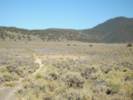
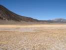
Trench Canyon from the southwest. |
Drainage Divide: Trench Canyon to the Northeast
|
|
Literature Cited:
- Russell, Israel C., 1889.
|
Russell (1889, p. 272) describes a trip through Trench Canyon thus:| Riding southward we traverse the long, deep pass that attracted our attention from the hills above, connecting Aurora and Mono Valleys. From the particular form of this straight, narrow gorge we name it Trench Cañon. Advancing, we observe that the ancient beaches seen about Aurora Valley extend entirely through, as parallel horizontal lines on each side of the trough, at an elevation of about 200 feet, and are marked in places with tufa deposits. At the south end of Trench Cañon the bottom rises to within eighty feet of the highest ancient beaches, and shows evidences of having been eroded by the currents that once set through it. The terraces on either side of the cañon, where it opens out into Mono Valley, are more strongly defined and more numerous than at any other locality thus far seen during our ride (Russell, 1889, p. 272) |
|
|
|
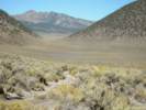
Bottom of Trench Canyon
|
|
|
Drainage Divide: Trench Canyon to the West
|
|
Other articles:
• Field Notes:
23-Sep-06 at Larkin Lake;
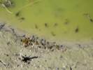 Pollywogs, dead pollywogs, and yellow jackets at Larkin Lake. Pollywogs, dead pollywogs, and yellow jackets at Larkin Lake.
|
In the center of Larkin Lake, a hole has been scooped out, and resulting depression contained some very green water. There were pollywogs in the water, some of which had front and back legs. But many had died. The yellow jackets were swarming to eat the dead pollywogs. Later, having returned home, I reviewed the collections of frogs at the Museum of Vertebrate Zoology (MVZ). There are four species of frogs that have been collected in Mono County. They are: - Great Basin Spadefoot Toad (Spea intermontana).
- Mountain Leopard Frog (Rana pipiens).
- Mountain Yellow-legged Frog (Rana muscosa).
- Pacific Tree Frog (Pseudacris regilla).
Of the four species, it seems more likely that the species I found at Larkin Lake is the Great Basin Spadefoot Toad. The true frogs (Rana sp.) and the tree frog (Pseudacris regilla) have been collected in the Sierra Nevada of Mono County, or at the Sierra front, but not out in the Great Basin of Mono County.
|
|
Other articles:
• Field Notes:
23-Sep-06 at Larkin Lake;
 Mud hole in Larkin Lake. Mud hole in Larkin Lake.
|
|
|
Other articles:
• Field Notes:
23 Sep 2006;
Locations:
Larkin Lake.
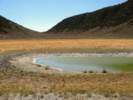
 Larkin Lake from the south edge. Larkin Lake from the south edge.
|
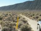
Road skirts the edge of Larkin Lake
|
|
Literature Cited:
- Wilusz, John P., 2002.
Other articles:
• Field Notes:
23 Sep 2006;
 California State Border near Larkin Lake California State Border near Larkin Lake
|
California above.
Nevada below.
|
|
Other articles:
• Power Line Road:
86870;
• Forest Road 058:
at Power Line Rd;
|
Junction: Forest Road 058, Forest Road 058 and the Power Line Road are actually separated by about 1/4 mile in thi area.- Turn left, north, for the Power Line Road to Mount Hicks, Aurora, and other points north.
- Go straight, east, for Alkali Lake.
- Turn right, south, to exit Alkali Valley, and to Nevada State Route 359.
|
|
If you have a question or a comment you may write to me at:
tomas@schweich.com
I sometimes post interesting questions in my FAQ, but I never disclose your full name or address.
|
[Home Page] [Site Map]
Date and time this article was prepared:
7/13/2024 8:02:38 AM
|
 Eastern Mojave Vegetation