Eastern Mojave Vegetation
Tom Schweich
|
Eastern Mojave Vegetation
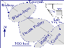
| Death Valley Geology -- A Botanist's View |
|
Tom Schweich |

Topics in this Article: Rock Units Geomorphology Economic Geology |
Try as I might, I am unable to ignore the substrate for the plants I study. Over the years, notes about rock units, sand dunes, and mines have accumulated at such a rate as to present the alarming possibility that I might be nearly as interested in the geology as the botany. My intention for this page is to present those notes as a very brief review of the geology immediate to Lobo Point and the Mid Hills. | ||||||||||||||||||||||||||||||||||||||||||||||||||||||||||||||||||||||||||||||||||||||||||||||||||||||||||||||||||||||||||||||||||||||||||||||||||||||||||||||||||||||||||||||||||||||||||||||||||||
|
|
IntroductionThese notes comprise readily accessible data about the rock units, the common geomorphic features and the economic geology of the Death Valley region. There are many other sources of information. Web sites prepared by the U. S. G. S. are also excellent starting places for additional information.Both the National Park Service and the United States Geological Survey have web pages about the geology of Mojave National Preserve. You can find them at:
| ||||||||||||||||||||||||||||||||||||||||||||||||||||||||||||||||||||||||||||||||||||||||||||||||||||||||||||||||||||||||||||||||||||||||||||||||||||||||||||||||||||||||||||||||||||||||||||||||||||
| This article is one of three geology articles on my web site. The other two pages are: Eastern Mojave Geology and Inyo-White Geology. | |||||||||||||||||||||||||||||||||||||||||||||||||||||||||||||||||||||||||||||||||||||||||||||||||||||||||||||||||||||||||||||||||||||||||||||||||||||||||||||||||||||||||||||||||||||||||||||||||||||
|
|
Geologic Time Scale.The University of California Museum of Paleontology has a excellent Geologic Time Scale. | ||||||||||||||||||||||||||||||||||||||||||||||||||||||||||||||||||||||||||||||||||||||||||||||||||||||||||||||||||||||||||||||||||||||||||||||||||||||||||||||||||||||||||||||||||||||||||||||||||||
|
|
Rock Units | ||||||||||||||||||||||||||||||||||||||||||||||||||||||||||||||||||||||||||||||||||||||||||||||||||||||||||||||||||||||||||||||||||||||||||||||||||||||||||||||||||||||||||||||||||||||||||||||||||||
| In this chapter, rock units are presented in time sequence from oldest rocks to youngest rocks. | |||||||||||||||||||||||||||||||||||||||||||||||||||||||||||||||||||||||||||||||||||||||||||||||||||||||||||||||||||||||||||||||||||||||||||||||||||||||||||||||||||||||||||||||||||||||||||||||||||||
|
|
PrecambrianPrecambrian metamorphic gneiss and schist crop out just north of the North Wild Horse Mesa and Lobo Point. | ||||||||||||||||||||||||||||||||||||||||||||||||||||||||||||||||||||||||||||||||||||||||||||||||||||||||||||||||||||||||||||||||||||||||||||||||||||||||||||||||||||||||||||||||||||||||||||||||||||
Hadean | |||||||||||||||||||||||||||||||||||||||||||||||||||||||||||||||||||||||||||||||||||||||||||||||||||||||||||||||||||||||||||||||||||||||||||||||||||||||||||||||||||||||||||||||||||||||||||||||||||||
Archaean | |||||||||||||||||||||||||||||||||||||||||||||||||||||||||||||||||||||||||||||||||||||||||||||||||||||||||||||||||||||||||||||||||||||||||||||||||||||||||||||||||||||||||||||||||||||||||||||||||||||
Proterozoic Era | |||||||||||||||||||||||||||||||||||||||||||||||||||||||||||||||||||||||||||||||||||||||||||||||||||||||||||||||||||||||||||||||||||||||||||||||||||||||||||||||||||||||||||||||||||||||||||||||||||||
Paleoproterozoic | |||||||||||||||||||||||||||||||||||||||||||||||||||||||||||||||||||||||||||||||||||||||||||||||||||||||||||||||||||||||||||||||||||||||||||||||||||||||||||||||||||||||||||||||||||||||||||||||||||||
Mesoproterozoic | |||||||||||||||||||||||||||||||||||||||||||||||||||||||||||||||||||||||||||||||||||||||||||||||||||||||||||||||||||||||||||||||||||||||||||||||||||||||||||||||||||||||||||||||||||||||||||||||||||||
|
Locations: Badwater. Black Mountains. Dante's View. Hanaupah Canyon. Panamint Range. |
Metamorphic schists and gneisses, and intrusive granitic bodies. Age at least 1 billion years. Geosynclinal. Exposed in the Black Mountains at Dante's View and Badwater, and in the Panamint Mountains north of Hanaupah Canyon. Overlain by later Precambrian rocks. | ||||||||||||||||||||||||||||||||||||||||||||||||||||||||||||||||||||||||||||||||||||||||||||||||||||||||||||||||||||||||||||||||||||||||||||||||||||||||||||||||||||||||||||||||||||||||||||||||||||
Rocks of the Crystalline Basement | |||||||||||||||||||||||||||||||||||||||||||||||||||||||||||||||||||||||||||||||||||||||||||||||||||||||||||||||||||||||||||||||||||||||||||||||||||||||||||||||||||||||||||||||||||||||||||||||||||||
|
Literature Cited:
|
Rocks of the crystalline basement are metasedimentary with granitic intrusions and include schists and gneisses. One coarse facies of gneiss contains large feldspar crystals known as augen (Hunt, 1975, p. 96). These rocks are mapped as epC on the Geologic Atlas of California (1958) and listed as Panamint metamorphic complex and World Beater porphyry. | ||||||||||||||||||||||||||||||||||||||||||||||||||||||||||||||||||||||||||||||||||||||||||||||||||||||||||||||||||||||||||||||||||||||||||||||||||||||||||||||||||||||||||||||||||||||||||||||||||||
|
Literature Cited:
|
"... the World Beater area must have stood above sea level during Pahrump time ..." (Labotka and Albee, 1977). | ||||||||||||||||||||||||||||||||||||||||||||||||||||||||||||||||||||||||||||||||||||||||||||||||||||||||||||||||||||||||||||||||||||||||||||||||||||||||||||||||||||||||||||||||||||||||||||||||||||
|
Literature Cited:
Locations: Galena Canyon. Hanaupah Canyon. |
"... may be seen in the steep front of the Black Mountains ... close to the highway near Badwater and farther south ... at the head of Galena Canyon ... east front of Panamint Range north of Hanaupah Canyon..." (Hunt, 1975, p. 94). | ||||||||||||||||||||||||||||||||||||||||||||||||||||||||||||||||||||||||||||||||||||||||||||||||||||||||||||||||||||||||||||||||||||||||||||||||||||||||||||||||||||||||||||||||||||||||||||||||||||
Neoproterozoic | |||||||||||||||||||||||||||||||||||||||||||||||||||||||||||||||||||||||||||||||||||||||||||||||||||||||||||||||||||||||||||||||||||||||||||||||||||||||||||||||||||||||||||||||||||||||||||||||||||||
| The Neoproterozoic is thought to span the time period from 900 to 543 mya (million years). | |||||||||||||||||||||||||||||||||||||||||||||||||||||||||||||||||||||||||||||||||||||||||||||||||||||||||||||||||||||||||||||||||||||||||||||||||||||||||||||||||||||||||||||||||||||||||||||||||||||
|
Literature Cited:
|
The initial stage in the evolution of the California continental margin was the deposition of the miogeoclinal sediment wedge along a passive continental margin of Atlantic type (Stewart, 1972). | ||||||||||||||||||||||||||||||||||||||||||||||||||||||||||||||||||||||||||||||||||||||||||||||||||||||||||||||||||||||||||||||||||||||||||||||||||||||||||||||||||||||||||||||||||||||||||||||||||||
|
Literature Cited:
|
The rifting that initiated deposition was accompanied or preceded by basaltic volcanism at about 850 m. y. (Dickinson, 1977). | ||||||||||||||||||||||||||||||||||||||||||||||||||||||||||||||||||||||||||||||||||||||||||||||||||||||||||||||||||||||||||||||||||||||||||||||||||||||||||||||||||||||||||||||||||||||||||||||||||||
|
Literature Cited:
|
Continental separation was probably not completed, however, until about 650 m. y. b. p. (Stewart and Suczek, 1977) | ||||||||||||||||||||||||||||||||||||||||||||||||||||||||||||||||||||||||||||||||||||||||||||||||||||||||||||||||||||||||||||||||||||||||||||||||||||||||||||||||||||||||||||||||||||||||||||||||||||
|
Literature Cited:
|
The succession of Precambrian-Cambrian rock units from the southeast near Las Vegas to the northwest in the Inyo-White mountain ranges show facies changes from continental deposits through shallow water or continental margin deposits in the death Valley area to deep water deposits in the Inyo-White Mountains. | ||||||||||||||||||||||||||||||||||||||||||||||||||||||||||||||||||||||||||||||||||||||||||||||||||||||||||||||||||||||||||||||||||||||||||||||||||||||||||||||||||||||||||||||||||||||||||||||||||||
Pahrump Series
|
The Pahrump series contains slightly metamorphosed sedimentary rocks of the Crystal Spring, Beck Spring and Kingston Peak formations. They were deposited in the Amargosa aulacogen bordered by the Nopah upland on the north and the Mojave upland to the south.
|
|
In general, Pahrump time seems to correspond with "Belt" time of deposition in the Precambrian Belt Basin of western Montana and adjacent Canada.
|
|
| Crystal Spring Formation
|
Upper member
Chert member
Algal Member
Dolomite member
Mudstone member
Feldspathic sandstone member
Arkose member
|
|
Literature Cited:
The Crystal Spring formation, about 2,000 feet thick, "...consists of a basal conglomerate overlain by quartzite that grades upward into purple shale and thinly bedded dolomite; upper part, thick bedded dolomite, diabase, and chert .." (Hunt, p. 93) "... rests with profound unconformity on older Precambrian metamorphic and igneous rocks" (Roberts, 1976, p. 35).
|
|
Literature Cited:
Roberts (1976) analyzed the middle and lower members as shown in :figref refid=csf1. and concluded that it was deposited during the initiation of a late Precambrian intracratonal trough. "... contains Baicalia stromatolites ... suggests a middle Riphean age (1,350 to 950 m.y.) for the algal member ... also contains Conophyton stromatolites ... the Baicalia-Conophyton association is typically middle Riphean ... age may be 1,350 to 1,2000 m.y. ..." (Roberts, 1976).
|
|
Literature Cited:
"...intruded by sheets of diabase ... the carbonates are altered to talc ... extensively mined" (Hunt, 1975, p. 96).
|
|
| Beck Spring Dolomite
|
Literature Cited:
The Beck Spring dolomite is the middle formation of the Pahrump series. Hunt (1975, p. 93) notes that it "... outcrops to the west. Blue-gray cherty dolomite; thickness estimated at 500 feet; identification uncertain". However, Labotka and Albee (1977) report that the "... Beck Spring dolomite lies conformably on the Crystal Spring throughout most of the Telescope Peak Area ... consists of 200 to 300 meters of massive bedded dolomite and sandy dolomite ... upper part ... on Sentinal Peak is predominately clastic and interfingers with quartz-rich arenite".
|
|
| Kingston Peak Formation
|
Literature Cited:
The Kingston Peak Formation is "... mostly conglomerate, quartzite, and shale; some limestone and dolomite near middle. At least 3,000 feet thick" (Hunt, 1975, p. 93). It is "...northward thinning ... well displayed in exposures in the Black Mountains north of the highway between Jubilee Pass and the Ashford Mill site" (Wright, Troxel, Williams, Roberts and Diehl, 1976, p. 9).
|
|
Unconformity.
|
|
Literature Cited:
"... may represent provenance of Cordilleran miogeosyncline ..." (source unknown) "A slight angular unconformity above the Pahrump group is indicated by the truncation of the uppermost units in the Kingston Peak Formation by the Noonday Dolomite" (Labotka and Albee, 1977).
|
|
Other articles:
| Noonday Dolomite
|
Literature Cited:
Exposed in the southern Panamint range. Williams, Wright and Troxel (1976) discuss it in detail. Consists of "... dolomite in indistinct beds; lower part cream colored, upper part gray. Thickness, 800 feet" (Hunt, 1975, p. 92). Farther north, where mapped as Noonday (?) dolomite, it contains much limestone which is colored tan and white, and some limestone conglomerate. Its thickness there is about 1,000 feet (Hunt, 1975, p. 92).
|
|
Locations: Mosiac Canyon.
Most of lower Mosaic Canyon is through Noonday Dolomite (November 26, 1981).
|
|
| Johnnie Formation
|
Literature Cited:
The Johnnie Formation is "... mostly shale, in part olive brown, in part purple. Basal member 400 feet thick is interbedded dolomite and quartzite with pebble conglomerate. Locally, tan dolomite near middle and top. Thickness more than 4,000 feet" (Hunt, 1975, p. 92).
|
|
| Stirling
|
Literature Cited:
Stirling Quartzite has been described as "...well bedded quartzite in beds 1 to 5 feet thick comprising thick members of quartzite 700 to 800 feet thick separated by 500 feet of purple shale, cross bedding conspicuous in quartzite. Maximum thickness about 2,000 feet" (Hunt, 1975, p. 93).
|
|
| Paleozoic
|
Most of the exposed Paleozoic rocks are Cambrian in age.
|
|
Marine deposits about 8,000 feet thick. Fossils found include trilobites. Exposed in the Panamint Mountains in Trail Canyon and on Tucki Mountain. Also found in the Funeral Mountains.
|
|
| Cambrian
|
| Wood Canyon Formation.
|
Literature Cited:
Diehl (1976) provides a good description of the Wood Canyon formation:
|
|
Nolan (1924) named the Wood Canyon Formation and described it from exposures in the northwest part of the Spring Mountains, Nevada. Hazzard (1937) extended the use of the name to the southern Nopah Range ... where he measured a section of Precambrian to Cambrian strata including those of the Wood Canyon Formation. Later, Stewart (1966 ...) divided the formation into lower, middle, and upper informal members.
|
|
Still more recently, Stewart (1970), in a systematic regional stratigraphic study of the Wood Canyon and associated formations of the southern Great Basin, California and Nevada
|
|
The Wood Canyon Formation is of particular interest because it has diverse lithologies, occupies a stratigraphic position athwart or near the Proterozoic-Paleozoic boundary, and its areal distribution is well documented. The section that contains the Wood Canyon and the underlying Stirling Quartzite, Johnnie Formation, and Noonday Dolomite in the southern part of the Nopah Range has been suspected as a possible stratotype for the Proterozoic-Phanerozoic boundary (Cloud, 1973).
|
|
The Wood Canyon Formation has been divided previously into three informal members that are recognizable over a large area of eastern California and western Nevada.
|
|
...The lower member is composed of interbedded siltstone (36 percent), thinly laminated to platy bedded, fine- to medium-grained feldspathic and micaceous sandstone (50 percent), and laminated, siliceous dolomite (14 percent). The latter occurs primarily as three subunits in the member... Mudcracks, trace fossils, loading features, scoured surfaces, and discontinuous, convex sandstone bodies that are cross-laminated suggest shallow water deposition
|
|
...The middle member contains a lower sub-unit composed of arkosic conglomerate and grades up-section into cyclically bedded subarkosic sandstone and maroon siltstone.
|
|
The interbedded light olive-gray to tan siltstone (23 percent) and dark brown to pale red weathering, fine- to very fine-grained quartzitic sandstone (49 percent) of the upper member are similar to those in the lower member with respect to distribution and primary sedimentary features. Sandstone beds are 1 to 5 feet thick, well laminated to massive with occasional cross-laminations. The dolomite (12 percent) in the upper member is contained mostly in one sub-unit, which is characteristically cyclically bedded. Distinctive millimeter-sized platelets of echinodermal debris are found in the dolomite beds.
|
|
Locations: Salt Spring Hills.
The dolomite sub-unit of upper member in the south Salt Spring Hills is 20 feet thick, whereas in Mosaic Canyon, at the north end of the Panamint Range, the correlative sub-unit is 340 feet thick.
|
|
In addition to the gross subdivision of the Wood Canyon into three members, a further subdivision into at least 18 sub-units is recognizable.
|
|
Literature Cited:
Hunt (1975, p. 92) notes that the Wood Canyon Formation contains "... a few scattered olenellid trilobites and archaeocyathids in upper part ..." and Scolithus tubes.
|
|
Literature Cited:
"... overlies and is gradational with the Stirling Quartzite, suggesting that sedimentation was continuous"(Hunt, 1975, p. 99). "... best exposures, along Blackwater Canyon ... most accessible exposures are in Echo Canyon and at Death Valley Buttes... "(Hunt, 1975, p. 99). "In Hanaupah Canyon (the Burro Trail fault) dips 15 degrees west; beds of the ... Wood Canyon Formation in the upper plate dip east into the fault"(Hunt, 1975, p. 140). "The oldest recognizable fossils in Paleozoic formations in Death Valley region are fragments of trilobites which occur in shale beds crossing saddle ..." between Tucki and Blackwater washes (Hunt, 1975, p. 99).
|
|
11?27?81 -- Should have seen Wood Canyon Formation in Titus Canyon, just below Klare Spring, but it wasn't recognizable from a distance. No bedding was visible from a distance and there wasn't time to examine the slopes up close. Generally it would appear to weather to talus slopes.
|
|
| Zabriskie Quartzite
|
... probably correlates with the Prospect Mountain Quartzite in the Craton facies ...
|
|
11?27?81 -- missed it in Titus Canyon.
|
|
| Carrara Formation
|
Literature Cited:
"... an alternation of shaly and silty members with limestone members; transitional between underlying clastic formations and overlying carbonate ones. Thickness about 1000 feet but variable because of shearing" (Hunt, 1975, p. 92).
|
|
The primary reference for the Carrara formation seems to be: Cornwall, H. R. and F. J. Kleinhampl, 1961, Geology of the Bare Mountain quadrangle, Nevada, U. S. Geological Survey Map GQ?157, scale 1:62,500.
|
|
McAllister (1970) provides this summary of the Carrara formation: The Carrara formation, of early and middle Cambrian age, displays the transition from siliceous clastic to carbonate rocks, apparent even from a distance, by a diversity of colors and varied relief of different layers. In the lowest part of the Carrara, light colored quartzite and dark shale resemble rocks in the underlying Zabriskie and Wood Canyon formations, whereas silty limestone in the highest part resembles limestone in overlying formations. Three prominent sets of limestone beds, separated by predominantly shaly and silty beds, stand out as ridges or as ribs on steep slopes. The two lower sets are conspicuously gray, but the highest is partly subdued by brown weathering clastic material. Much of the limestone, either silty or purer, contains concentrically structured ovoids as much as two inches long, generally attributed to the alga Girvanella.
|
|
Diagnostic trilobites in particular beds well spaced through the Carrara make it one of the most significantly fossiliferous formations in the section. They demonstrate that the lower part is early Cambrian and the upper part is middle Cambrian.
|
|
In the Dry Mountain quadrangle, the Carrara formation "... crops out only in the low hills 4 1/2 miles east of Dry Mountain ...", along the west side of Racetrack Road, and "... along the western boundary of the quadrangle in the Saline Range" (Burchfiel, 1969, p. 2).
|
|
Burchfiel (1969, p. 2) discusses the Carrara formation as it crops out near Racetrack Road as follows: East of Dry Mountain, the lower 600 feet of the Carrara Formation is composed of interbedded green and brown shale, orange-weathering silty limestone, gray to dark gray coarse-grained limestone, and brown calcareous sandstone and quartzite. The limestone beds range in thickness from six inches to two feet and may be grouped into ledge-forming limestone units up to 40 feet thick. Algal (?) pisolites up to two inches in diameter are common in the limestones. Overlying the basal shales are 900 feet of Carrara rocks containing two distinct limestone units. The lower limestone unit is about 250 feet thick and consists of dark gray thick-bedded coarse- to medium-grained limestone containing pisolites. Orange-weathering silty limestone is present at the top and bottom of this unit and grades into the green shale below and red, brown and green shaly siltstone above. The upper limestone unit is about 200 feet thick, consisting of gray and light gray limestone and dolomite. A prominent cream-colored band of dolomite occurs near the top.
|
|
Literature Cited:
DeCourten (1979) identifies the following three formations of Hazzard (1936, 1954) as being correlative with parts of the Carrara formation: Latham shale, Chambless limestone, and Cadiz formation.
|
|
Literature Cited:
Hazzard's (1954) Kelso shale, while the terminology is not clear, may also be correlative with parts of the Carrara formation. "... numerous trilobite trash beds in the lower part yield fragments of olenellid trilobites" (Hunt, 1975, p. 100)
|
|
"Many of the sandy limestones contain trilobite remains in the Dry Mountain quadrangle" (Burchfiel, 1969, p. 2).
|
|
Literature Cited:
"... numerous exposures on both sides of Echo Canyon, just above the canyon mouth, and in the upper part of Trail Canyon" (Hunt, 1975, p. 100)
|
|
11?26?81 -- May have seen some dark gray Carrara shale with ripple marks from the car in Daylight Pass. Ditto, Titus Canyon, below Klare Spring.
|
|
| Bonanza King Formation
|
Literature Cited:
Bonanza King Formation: ... middle to upper Cambrian ... mostly chemical precipitates ... "... most accessible outcrops are in Trail and Echo canyons ..." (Hunt, 1975, p. 102)
|
|
11?27?81 -- easy to recognize in Titus Canyon by its cliff forming and cavernous attributes ... appears massive in Titus Canyon ... outcrop of Bonanza King Formation at Upper Warm Spring in Saline Valley had many layers of cyclic beds, each cycle 1 to 1.5 meters in thickness ... suggests cyclically changing environments ... some stromatolites ... suggest shallow water
|
|
| Nopah Formation
|
| Ordovician
|
Thickness 2,500 feet. Exposed in the Panamint Mountains in Trail Canyon and on Tucki Mountain.
|
|
A coiled mollusc fossil was found in Ordovician(?) carbonate rock near the mouth of Trail Canyon. A quartzite of unknown age was found in the mouth of Trail Canyon.
|
|
| Silurian
|
Contains fossil corals, crinoids and brachiopods. Present day corals require a water temperature of 68 F, a water depth of less than 150 feet and clear water. Exposed on Tucki Mountain in the Panamint Mountains.
|
|
| Devonian
|
| (Carboniferous)
|
All sedimentary rock, mostly limestone. Fossils include corals, crinoids and brachiopods. Exposed in the Panamint Mountains on Tucki Mountain. Post-Cambrian Paleozoic rocks also occur in the southern part of the Funeral Mountains.
|
|
| Mississippian
|
| Pennsylvanian
|
| Permian
|
| Mesozoic
|
At the beginning of the Mesozoic, the continents of the Earth formed a supercontinent called Pangea. The western or northwestern coast of the supercontinent was the Panthalassa Ocean.
|
|
| Triassic
|
Marine sediments. Fossiliferous. Some volcanic rocks(?). Exposed in the southern Panamints.
|
|
| Hunter Mountain Quartz Monzonite
|
| Jurassic
|
Mostly granitic intrusive rocks exposed in the Black Mountains and the southern Panamint Range.
|
|
| Cretaceous
|
| Cenozoic
|
| Tertiary
|
Volcanic and sedimentary rocks exposed along the flanks of southern and central Death Valley. They underlie Death Valley and other topographic depressions.
|
|
| Paleocene
|
| Eocene
|
| Oligocene
|
Oldest Tertiary deposits. Exposed in the Titus Canyon area in the Grapevine Mountains and in the Funeral Mountains.
|
|
Oligocene to Miocene deposits are represented by the Artist's Drive formation. Composed of volcanic rocks, sedimentary rocks and playa deposits. Thickness is about 13,000 feet. Fossils include fresh water diatoms. Faulted and folded against the Precambrian core of the Black Mountains. In the northern Black Mountains, the Artist's Drive formation is overlain by the Furnace Creek formation of Pliocene age.
|
|
11?25?80 -- George Hilton thinks colors result from fumarolic alteration of waterlain volcanic ash.
|
|
| Miocene
|
| Pliocene
|
Furnace Creek formation. Composed of Alluvial Fan deposits, playa deposits, and gypsum. Exposed at Zabriskie Point.
|
|
11?26?81 -- In some exposures, certain strata have white evaporites at surface.
|
|
| Quaternary
|
Tephra at Ubehebe Crater:
|
|
Includes alluvial fans, playa, salt pans, sand dunes, and cinder cones. Salts interlayered with clays and silt underlie at least 125 square miles of the floor of Death Valley to a depth of at least 1,000 feet. Salt pan is generally zoned, from the inside to the outside: Chloride zone, Sulfate zone, Carbonate zone, Alluvial fans. The northern salt pan tends to have more calcium carbonates and the southern salt pan tends to have more sodium carbonates. This is a function of the source rocks.
|
|
| Pleistocene
|
| Holocene
|
| Geomorphology
|
| Sand Dunes
|
| Economic Geology
If you have a question or a comment you may write to me at:
tomas@schweich.com
I sometimes post interesting questions in my FAQ, but I never disclose your full name or address.
|
|
Date and time this article was prepared: 4/21/2025 8:21:00 PM |