
|
Kingston Road was the original route from Valley Wells in the Shadow Valley to Jean in the Ivanpah Valley via Goodpsrings. It was originally opened as a toll road..
|
|
Other articles:
• NV Hwy 161:
60000;
Locations:
Jean.
|
Junction: Nevada Highway 161, to U. S. Interstate 15 at Jean, Nevada.
|
|
Literature Cited:
- Hewett, D. F., 1931.
Other articles:
• FAQ:
Goodsprings;
• Routes to Water:
at Goodsprings;
Locations:
Goodsprings.
|
Goodsprings
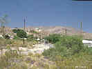
Goodsprings, Nevada |
|
|
Locations:
Aztec Tank.
Mesquite Mountains.
 Location of Aztec Tank, type locality of Aztec Sandstone. Location of Aztec Tank, type locality of Aztec Sandstone.
 Sandy Valley and the Mesquite Mountains. Sandy Valley and the Mesquite Mountains.
|
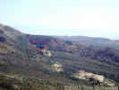
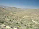
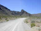
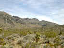
Just south of Wilson Pass a road goes up to some radio towers. Some great views are had from here, including Goodsprings and Sandy Valley.
|
 Kingston Road south of Wilson Pass. Kingston Road south of Wilson Pass.
|
|
|
Locations:
Wilson Pass.
|
Wilson Pass
|
 Kingston Road north of Wilson Pass. Kingston Road north of Wilson Pass.
|
|
|
Other articles:
• Potosi Mountain Road:
90000;
|
Junction: Potosi Mountain Road, to Potosi Valley, Potosi Spring, and eventually Kingston Road near Wilson Pass.
|
|
Other articles:
• Sandy Valley Road:
Sandy Valley;
|
Sandy Valley
Junction: Sandy Valley Road
|
|
Locations:
Mesquite Mountains.
 Kingston Road at the California-Nevada border Kingston Road at the California-Nevada border
|
Nevada above
California below
|
|
Other articles:
• Field Notes:
20 Apr 2004;
18 Apr 2017;
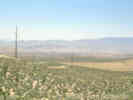
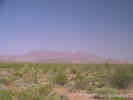
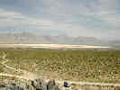 View of Mesquite Lake and Mesquite Valley View of Mesquite Lake and Mesquite Valley
 Dust blown off the surface of Mesquite Lake. Dust blown off the surface of Mesquite Lake.
|
The first outcropping of limestone on the north side of the road is also an informal dump. It was here that I made my collections 350 - 352, plus taking some photographs of some plants of which I only saw one.
|
|
Locations:
Sandy Valley.
 Sandy Valley, looking east from the margin of the Mesquite Mountains. Sandy Valley, looking east from the margin of the Mesquite Mountains.
|
|
|
Locations:
Mesquite Mountains.
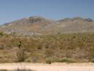
 Kingston Road on the east side of the Mesquite Mountains. Kingston Road on the east side of the Mesquite Mountains.
|
|
|
Other articles:
• Field Notes:
Coll. No. 354;
Coll. No. 355;
Coll. No. 356;
Coll. No. 380, 22 April 2004;
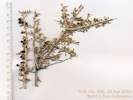
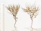
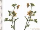
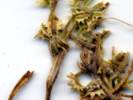
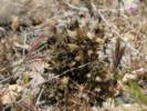
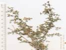
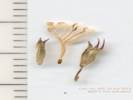
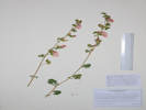
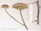 Coll. No. 354, Cirsium neomexicanum Coll. No. 354, Cirsium neomexicanum
 Coll. No. 355, Phacelia vallis-mortae Coll. No. 355, Phacelia vallis-mortae
|
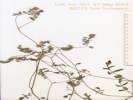
Coll. No. 356, Lycium andersonii |
Coll. No. 380, Cryptantha |
At a narrow point of the canyon, and a bend in Kingston Road, there is a fence line and cattle guard. Also, just to the south side of the road is a small rock shelter.
|
|
Other articles:
• Field Notes:
Coll. No. 319, 27 May 2013;
Coll. No. 320;
Coll. No. 321, 27 May 2003;
Coll. No. 1581, 18 Apr 2017;
Coll. No. 1582, 18 Apr 2017;
Coll. No. 1583, 18 Apr 2017;
Coll. No. 1584, 18 Apr 2017;
Coll. No. 1585, 18 Apr 2017;
Coll. No. 1586, 18 Apr 2017;
Coll. No. 1587, 18 Apr 2017;
Coll. No. 1588, 18 Apr 2017;
Coll. No. 1588.5, 18 Apr 2017;
Coll. No. 1589, 18 Apr 2017;
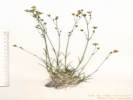
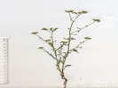
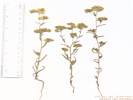
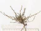
 Coll. No. 1583, Xylorhiza tortifolia Coll. No. 1583, Xylorhiza tortifolia
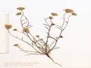
 Coll. no. 319, Diplacus bigelovii var. bigelovii Coll. no. 319, Diplacus bigelovii var. bigelovii
|
Coll. No. 320, Eriogonum nidularium |
Coll. No. 321, Phacelia vallis-mortae |
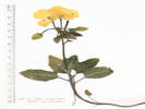
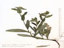
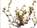
Coll. No. 1581, Ericameria linearifolia |
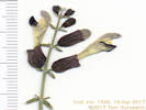
Coll. No. 1582, Eremogone macradenia var. macradenia |
Coll. No. 1584, Chylismia claviformis |
Coll. No. 1585, Salazaria mexicana |
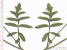
Leaf of Coll. No. 1586, Phacelia vallis-mortae |
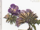
Inflorescence of Coll. No. 1586, Phacelia vallis-mortae |
Inflorescence of Coll. No. 1587, Pholistoma membranaceum |
Coll. No. 1588, Cryptantha utahensis |
Coll. No. 1588.5, Cryptantha or Plagiobothrys |
Coll. No. 1589, Bromus madritensis ssp. rubens |
Cherry stem road to the west.
|
|
Other articles:
• Field Notes:
20040422037305;
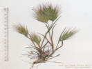
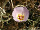 Calochortus flexuosus in the Mesquite Mountains Calochortus flexuosus in the Mesquite Mountains
|
On the south side of the road, climbing up to some dip-slope limestone outcrops, I saw 4-5 Calochortus flexuosus.
|
|
Other articles:
• Field Notes:
20040422037310;
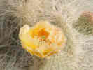
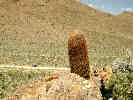 Large Barrel Cactus on quartzite outcrop. Large Barrel Cactus on quartzite outcrop.
|
I walked up to the quartzite outcrop on the south side of the road. On the way back to the car, I collected two different Atriplexes. Location was 11S 3953350 618750, elevation: 1000 m.
|
|
Other articles:
• Field Notes:
6 Jun 2006;
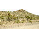
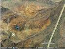 GoogleEarth image with aircraft flying over Mesquite Mountains. GoogleEarth image with aircraft flying over Mesquite Mountains.
|
Satellite image of an aircraft over the Mesquite Mountains.
|
|
Other articles:
• Field Notes:
20 Apr 2004;
Locations:
Winters Pass.
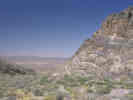
 Looking east into Nevada from Winters Pass Looking east into Nevada from Winters Pass
|
The view west from Winters Pass into Sandy Valley, Nevada.
|
|
Other articles:
• Field Notes:
20 Apr 2004;
Coll. No. 342;
Coll. No. 343, 20 April 2004;
Coll. No. 344;
Coll. No. 347, 0 Apr 2004;
Coll. No. 348;
Locations:
Mesquite Mountains.
Winters Pass.
 View south from Winters Pass View south from Winters Pass
|
Winters Pass
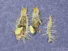
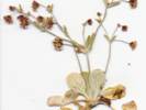
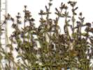
Coll. No. 343, Amsinckia tessellata var. tessellata |
Coll. No. 342, Xylorhiza tortifolia var. tortifolia |
Coll. No. 344, Lupinus flavoculatus |

Coll. No. 344, Lupinus flavoculatus |
Coll. No. 347, Cryptantha pterocarya var. cycloptera |
Coll. No. 348, Chaenactis carphoclinia var. carphoclinia |
Coll. No. 348, Chaenactis carphoclinia var. carphoclinia |
|
|
Other articles:
• Field Notes:
20050420445;
Coll. No. 445.1;
Coll. No. 446, 20 Apr 2005;
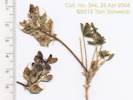
 Collection No. 445 from the Mesquite Mountains Collection No. 445 from the Mesquite Mountains
 Collection No. 445 from the Mesquite Mountains Collection No. 445 from the Mesquite Mountains
|
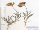
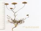
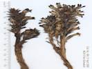
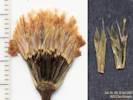
Coll. No. 445.1, Pectocarya heterocarpa |
Coll. No. 446, Eriogonum maculatum, from the Mesquite Mountains. |
Just south of Winters Pass, about 75 meters, is a small parking area, and a former road, now closed, that follows a ridge to the east.
|
|
Other articles:
• Field Notes:
21-Apr-05 Coll No. 453;
21-Apr-2005, Coll. No. 454;
21-Apr-05 Coll No. 455;
21-Apr-05 Coll No. 456;
21-Apr-05 at Winters Pass;
Locations:
Mesquite Mountains.
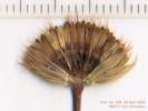
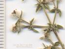
 Coll. No. 455, Hedeoma nana ssp. californica near top of Mesquite Mountains. Coll. No. 455, Hedeoma nana ssp. californica near top of Mesquite Mountains.
|
About 200 meters south of Winters Pass is a small road, now closed, that heads east.
If you want to climb to the top of the southern Mesquite Mountains, as shown in this photo, you could follow this road east as far as it leads to a saddle overlooking the Mesquite Valley, then turn north, climbing a ridge line, but stay a little to the east, to avoid the cliffs.
However, please be very clear that I am not recommending this route.
You follow this route at your own risk.
A direct approach to this summit would lead one into some pretty rough climbing.
Orobanche cooperi in the Mesquite Mountains, my Coll. No. 456. |
View of Mesquite Mountains summit from Winters Pass. |
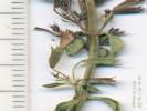
Coll. No. 453, Nicotiana obtusifolia, from the Mesquite Mountains. |
Detail of Coll. No. 453, Nicotiana obtusifolia from the Mesquite Mountains. |
Coll. No. 454, Galium stellatum |
Coll. No. 454, Galium stellatum |
Coll. No. 455, Hedeoma nana ssp. californica, from the Mesquite Mountains |
Coll. No. 455, Hedeoma nana ssp. californica |
Coll. No. 455, Hedeoma nana ssp. californica |
Coll. No. 456, Orobanche cooperi, collected near the top of the Mesquite Mountains. |
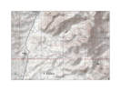
The route I took to the top of the Mesquite Mountains. |
|
|
Other articles:
• Field Notes:
Coll. No. 337.1;
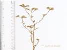
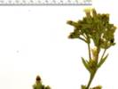
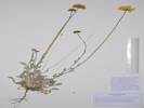 Coll. No. 337.1, Baileya multiradiata Coll. No. 337.1, Baileya multiradiata
|
About 5 miles north of Excelsior Mine Road, and 1 mile south of Winters Pass, just south of a small cherry-stem road.
|
|
Other articles:
• Field Notes:
Coll. No. 1578, 18 Apr 2017;
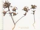
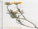
 Coll. No. 1578, Sphaeralcea ambigua Coll. No. 1578, Sphaeralcea ambigua
|
About 4.6 miles north of Excelsior Mine road, wash crosses Kingston Road.
|
|
Other articles:
• Field Notes:
20 Apr 2004;
Locations:
Winters Pass.
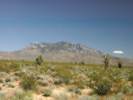
 Winters Pass as seen from one of the small hills in Winters Pass Hills. Winters Pass as seen from one of the small hills in Winters Pass Hills.
|
From a vantage point on the low Winters Pass Hills north of Kingston Road, one gets a better sense of Winters Pass being a low, broad pass separating the North and South Mesquite Mountains.
|
|
Other articles:
• Field Notes:
20 Apr 05 Looking for Langloisia;
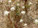
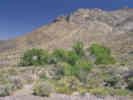
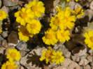 Eriophyllum wallacei in wash near the Wilson Pass Hills, Mesquite Mountains. Eriophyllum wallacei in wash near the Wilson Pass Hills, Mesquite Mountains.
|
When walking across the wash to the Winters Pass Hills from Kingston Road, there are often little wooly sunflowers (Eriophyllum wallacei) clustered in the washes.
|
|
Other articles:
• Field Notes:
20 Apr 04 Coll No 341;
Locations:
Goldhammer Mine.
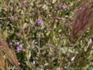
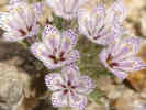 Lilac Subbonnet (Langoisia setosissima ssp. punctata) Lilac Subbonnet (Langoisia setosissima ssp. punctata)
|
Lilac Sunbonnet (Langloisia setosissima ssp. punctata) can be found on the south slopes of Winters Pass Hills, elevation 990 m (3500 ft) about mid-Spring. The 20th of April 2004 was just about perfect in terms of a full bloom of the species. However, 20 April 2005 was much too early because the early Spring was cool and cloudy. As a comparison, on 24 April 2005 we found Lilac Sunbonnet in full bloom at the Goldhammer Mine, which is 100 km (62 mi) south, at elevation 675 m (2280 ft), which is 215 m (1220 ft) lower in elevation.
|
|
Other articles:
• Field Notes:
20 Apr 2004;
 Mojave Prickly Pear (Opuntia erinacea) on the slopes of the Winters Pass Hills Mojave Prickly Pear (Opuntia erinacea) on the slopes of the Winters Pass Hills
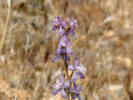 Parish's Larkspur (Delphinium parishii) on the slopes of the Winters Pass Hills. Parish's Larkspur (Delphinium parishii) on the slopes of the Winters Pass Hills.
|
|
|
Literature Cited:
- Corsetti, Frank A, and Alan J. Kaufman, 2003.
Other articles:
• Death Valley Geology:
148600;
• Field Notes:
20 Apr 04 near Winters Pass Hills;
Locations:
Winters Pass Hills.
|
Winters Pass Hills
Winters Pass Hills near Kingston Road |
Winters Pass Hills was the southeastern extent of investigation of the Noonday Dolomite and the Johnnie Formation by Corsetti and Kaufman (2003)
|
|
Other articles:
• Field Notes:
Coll. No. 1575, 18 Apr 2017;
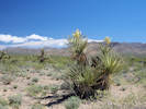 Coll. No. 1575, Yucca schidigera Coll. No. 1575, Yucca schidigera
|
At about 1.1 miles north of Excelsior Mine Road, location of collection #1575 Yucca schidigera and 1576 Ambrosia dumosa.
|
|
Other articles:
• Field Notes:
Coll. No. 330;
Coll. No. 335;
20050420510;
Locations:
Clark Mountain.
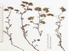
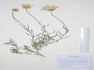
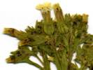
 Coll. No. 330, Desert Pincushion (Chaenactis fremontii) near the Mesquite Mountains. Coll. No. 330, Desert Pincushion (Chaenactis fremontii) near the Mesquite Mountains.
|
View of Clark Mountain from the north. |
Coll. No. 330, Chaenactis fremontii |
Coll. No. 330, Chaenactis fremontii |
Coll. No, 335, Lycium cooperi |
View to the south of Clark Mountain from Kingston Road.
|
|
Other articles:
• Excelsior Mine Road:
at Kingston Rd;
• Routes to Water:
at Kingston Rd Jct;
|
Junction:
- Excelsior Mine Road, to the Kingston Range, Horsethief Springs, Beck Spring, and eventually Tecopa and Shoshone.
- Goodsprings to Silver Lake, from Thompson's (1921), Routes to Watering Places
|
|
Locations:
Kingston Range.
 Kingston Range, seen from Kingston Road, just north of Valley Wells. Kingston Range, seen from Kingston Road, just north of Valley Wells.
|
|
|
Other articles:
• Keany Pass Road:
at Kingston Road;
|
Junction
Junction:, follows the powerlines through Keany Pass on the north side of Clark Mountain, eventually reaching U. S. Interstate 15 at Primm, Nevada.
|
|
Locations:
Clark Mountain.
 Canyon on west side of Clark Mountain. Canyon on west side of Clark Mountain.
 Pachalka Spring Pachalka Spring
|
Pachalka Spring. Large perennial spring on the west side of Clark Mountain, 5 miles of rough road.
|
|
|
|
|
Other articles:
• Field Notes:
20050420032;
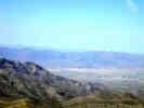
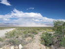
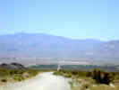
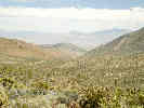
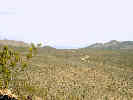
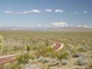 View of Shadow Valley, the Mesquite Mountains, and the Spring Mountains. View of Shadow Valley, the Mesquite Mountains, and the Spring Mountains.
|
A few miles north of Valley Wells, Kingston Road passes through some low hills and over a low pass. From here, the is often an excellent view of Shadow Valley and the Spring Mountains.
|
|
Other articles:
• Kessler Springs Road:
at Valley Wells;
• Interstate 15:
Valley Wells;
|
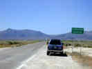
Valley Wells
Junction:- U. S. Interstate 15
, west to Los Angeles, and east to Las Vegas.- Kessler Springs Road
, south to Cima and Mojave National Preserve.
|
|
If you have a question or a comment you may write to me at:
tomas@schweich.com
I sometimes post interesting questions in my FAQ, but I never disclose your full name or address.
|
[Home Page] [Site Map]
Date and time this article was prepared:
4/21/2025 8:15:27 PM
|
 Eastern Mojave Vegetation