Eastern Mojave Vegetation
Edited by Tom Schweich
|
Eastern Mojave Vegetation
| Routes to Desert Watering Places in the Mohave Desert Region, California |
|
Edited by Tom Schweich |

Topics in this Article: Literature Cited |
Originally published in 1921 as USGS Water-Supply Paper 490-B. | ||||||||||||||||||||||||||||||||||||||||||||||||||||||||||||||||||||||||||||||||||||||||||||||||||||||||||||||||||||||||||||||||||||||||||||||||||||||||||||||||||||||||||||||||||||||||||||||||||||||||||||||||||||||||||||||||||||||||||||||||||||||||||||||||||||||||||||||||||||||||||||||||||||||||||||||||||||||||||||||||||||||||||||||||||||||||||||||||||||||||||||||||||||||||||||||||||||||||||||||||||||||||||||||||||||||||||||||||||||||||||||||||||||||||||||||
|
Other articles:
|
| ||||||||||||||||||||||||||||||||||||||||||||||||||||||||||||||||||||||||||||||||||||||||||||||||||||||||||||||||||||||||||||||||||||||||||||||||||||||||||||||||||||||||||||||||||||||||||||||||||||||||||||||||||||||||||||||||||||||||||||||||||||||||||||||||||||||||||||||||||||||||||||||||||||||||||||||||||||||||||||||||||||||||||||||||||||||||||||||||||||||||||||||||||||||||||||||||||||||||||||||||||||||||||||||||||||||||||||||||||||||||||||||||||||||||||||||
|
| |||||||||||||||||||||||||||||||||||||||||||||||||||||||||||||||||||||||||||||||||||||||||||||||||||||||||||||||||||||||||||||||||||||||||||||||||||||||||||||||||||||||||||||||||||||||||||||||||||||||||||||||||||||||||||||||||||||||||||||||||||||||||||||||||||||||||||||||||||||||||||||||||||||||||||||||||||||||||||||||||||||||||||||||||||||||||||||||||||||||||||||||||||||||||||||||||||||||||||||||||||||||||||||||||||||||||||||||||||||||||||||||||||||||||||||||
This route is much used by persons going from Goodsprings and Las Vegas, Nev., and neighboring points to Los Angeles, by way of Barstoe and San Bernardino. It is also possible to go from Goodsprings south to the National Old Trails road at Goffs or Fenner and thence west to Barstow. This route is about 65 miles longer than the road through Silver Lake, but it lies not far from railroads for most of the distance, where help can be obtained if necessary, and it also passes through several towns where supplies can be obtained. On the shorter route Silver Lake is the only place where supplies other than water can be procured in a distance of 140 miles.
|
|
Other articles:
Locations: Goodsprings.
0.0 Goodsprings. Go west on main street of town, turning south after crossing railroad track.
|
|
1.3 Turn to west up a canyon, joining a road on left (east). Road ascends a steep grade just east of divide.
|
|
Other articles:
Locations:
Columbia Pass.
3.6 Cross divide (Columbia Pass) and descend into canyon.
|
|
6.3 Avoid branch road on left (south) and turn to right (west) down alluvial slope.
|
|
10.6 Road comes in on left (east of south). Avoid road to abandoned town of Platina and go to old Sandy mill. Water at well with windmill a short distance east of the mill. Water is also obtainable at a dug well in the center of Platina and at a ranch on the site of the old town of Ripley, a short distance farther south. From the mill a road leads southwest across Mesquite Valley.
|
|
|
|
Locations: Sandy Mill.
11.6 Road forks. Geological Survey sign. Continue on left-hand road (south-west). Road on right leads to Pahrump, and to Tecopa and Zabriskie by way of Pahrump Valley. (See p. 208.)
|
|
12.7 Cross northwest-southeast road.
|
|
16. 3 Cross an old road. Main road continues southwest, ascending an alluvial slope into a canyon.
|
|
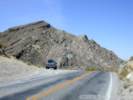
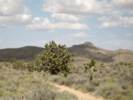
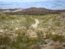
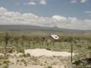
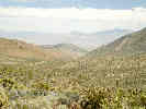 Looking east into Nevada from Winters Pass Looking east into Nevada from Winters Pass
|
|
Locations: Winters Pass.
21.5 Summit of divide (Winters Pass). Road continues south and later southwest.
|
|
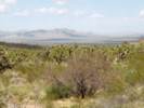
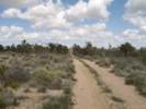
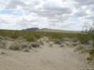
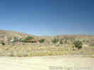
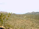 Winters Pass as seen from one of the small hills in Winters Pass Hills. Winters Pass as seen from one of the small hills in Winters Pass Hills.
|
|
Other articles:
27.1 Avoid branch road on left (south). (Kingston Road to Valley Wells).
|
|
Between milepost 27.1 and 28.2, this road is not shown on current-day maps. However, it is still visible on air photos.
|
|
28.2 Cross an arroyo in which are growing willows and cat's-claw.
|
|
Between milepost 28.2 and 32.6, this road appears on 7.5 minute quadrangle maps as a 4WD road.
|
|
32.6 Road comes in on right (north) from mine in Shadow Mountain.
|
|
Between milepost 32.6 and 33.9, this road is not shown on current-day maps. However, it is still visible on air photos.
|
|
33.9 Cross an old road.
|
|
35.1 Old road comes in on right (northwest).
|
|
Other articles:
|
|
Other articles:
Locations:
Francis Spring.
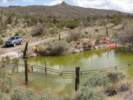
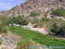
37.7 Francis Spring (on right). Geological Survey sign. The spring is about 200 feet southwest up the wash from a cattle trough and is covered with a wooden top. The water is classed as good for domestic use. From Francis Spring the road continues in a general southwesterly direction across a divide.
|
|
Other articles:
Pond near Francis Spring, not mentioned by Thompson (1921), perhaps more recent.
|
|
39.3 Road bends to right (southwest). Avoid old wagon tracks leading to left.
|
|
Locations: Riggs Wash.
40.0 Old road on right (west) leads to a well near head of Riggs wash (1.5 miles). Geological Survey sign. The well at this place is in the form of a tunnel, from which water is piped to a trough. From mile 40.0 continue southwest, descending into canyon.
|
|
Other articles:
|
|
Other articles:
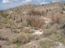
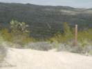
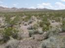
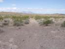
View east near Francis Spring.
|
|
Other articles:
View northeast to knob of granite
|
|
Other articles:
|
|
Other articles:
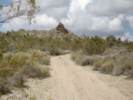
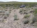
Descending the canyon from Turquoise Mountain.
|
|
47.5 Road forks. Continue southwest on right-hand road. Road to left (south) leads to Hytens Well (1 mile) and to Valley Wells. (See p. 209.)
|
|
Other articles:
|
|
Other articles:
|
|
Other articles:
Locations: Hytens Well.
48.8 Road comes in on left (south of east) from Hytens Well, Valley Wells, Nipton, and Cima. (See p. 209.) Geological Survey sign. Continue west.
|
|
Other articles:
View towards milepost 48.8, intersection with Halloran Springs Road.
|
|
Other articles:
View west from near the intersection with Halloran Springs Road.
|
|
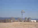
53.4 Branch road comes in on right (northeast) from talc prospect.
|
|
Other articles:
Locations: Silver Lake (site).
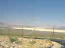
57.5 Silver Lake. Railroad crossing 0.1 mile south of station. Water, gasoline, meals, and sleeping accommodations for a limited number, and general supplies. From Silver Lake roads lead west to Barstow and Daggett (see p. 194) and to Leach Spring and Randsburg (see p. 174) ; north to Saratoga Springs, Owl Holes, and points in south Death Valley (see p. 202) ; and south to Baker and Soda stations (see p. 205).
|
|
|
|
|
|
This route is used principally for local travel between the points mentioned, but also to some extent by persons going from the mines near Valley Wells to Barstow, San Bernardino, and Los Angeles. Travelers going to the latter points will probably find it best to go from Nipton south to Goffs by way of Murphy Well, Ivanpah, and Barnwell, and thence west along the National Old Trails road. The distance from Nipton by way of Goffs is about 50 miles greater than by way of Silver Lake, but on the former route the roads are better for the greater part of the distance, and several supply points are passed.
|
|
Other articles:
Locations: Ivanpah Valley. Nipton.
0.0 Nipton. [Water, gasoline, food supplies, and sleeping accomodations for a limited number. From Nipton a road leads east to Searchlight, Nev. Water can probably be obtained on this road at Crescent wells.] Go west across south end of Ivanpah Valley.
|
|
Other articles:
Locations: Murphy Well.
4.2 Geological Survey sign. Murphy Well 100 yards to left. Good water is obtainable here only when cattle are being fed in the valley, as a man then lives at the well and pumps water to a storage tank. A road leads south past the well to Ivanpah, Barnwell, Lanfair, and Goffs. (See mile 28.8 of log on p. 236.)
|
|
5.9 Crossroads. Continue straight ahead (west). Road on left (south) leads to Cima, Ivanpah, Barnwell, and Goffs. Road on right (north) leads to Roach, Jean, and Goodsprings. (See mile 46.4 of log on p. 234.) This road does not appear on current maps, but can be faintly seen on air photos. On the edge of the clay lake bottom, relative to Ivanpah Road, it heads a little west of south until it joins the present-day Ivanpah Road, approximately 1.2 miles south of Nipton Road.
|
|
Other articles:
6.6 Crossroads. Geological Survey sign. Continue straight ahead (west) up alluvial slope. Road on left (south) leads to Cima, Ivanpah, Barnwell, and Goffs. Road on right (north) leads to Roach, Jean, and Goodsprings. Judging from the distances from Murphy Well, I think this is probably the present-day Ivanpah Road.
|
|
9.4 Old road comes in on left (southeast).
|
|
Locations: Wheaton Spring.
11.2 Road comes in on right (northwest) in wash. Geological Survey sign. Continue west. Road on right is from Roach. Jean, and Goodsprings. Water may be obtained at Wheaton Spring, half a mile southwest of this road junction, where a green spot may be visible on hillside. The water is piped from a tunnel to a trough. No road leads to the spring.
|
|
13.4 Roseberry Spring on right, just west of narrow pass. This spring is not dependable.
|
|
Locations: Mexican Well.
14.1 Mexican Well on right of road. Water is of fair quality.
|
|
Other articles:
Locations:
Mescal Spring.
14.6 Branch road to left (south) leads to Mescal Spring (see p. 212) and Cima. Mescal Spring is located about seven-tenths of a mile south and two-tenths of a mile west of this point. Continue west, avoiding branch roads leading north from main road, which continues west up the wash.
| This is likely Zinc Mine Road. The reference to "(see p. 212)" is a reference to routes between Silver Lake and Cima. It is not a reference to further information about Mescal Spring.
|
19.1 Avoid old road on left. Main road bends to right (northwest) around point of long east-west hill.
|
|
Locations: Mohawk Mine.
19.7 Camp of Mohawk mine on right.
|
|
Locations: Copper World Mine.
20.5 Avoid branch road on right (around point of hill) to Copper World and other mines.
|
|
20.9 Turn to left (south of west) on caterpillar road, which comes in on right (from east) from Copper World mine.
|
|
23.3 Branch road on left (south) leads to Cima. (See p. 212.) Continue west.
|
|
Other articles:
Locations:
Valley Wells Copper Smelter.
24.1 Pass Valley Wells copper smelter. A road comes in here on east from Cima. Continue west, descend hill, and turn slightly to left.
|
|
24.2 Corral at Valley Wells. Geological Survey sign. Water of only fair quality obtainable from dug well about 500 feet north of Geological Survey sign on east side of wash. Continue southwest past ranch house.
|
|
31.2 Old road conies in on left (southeast). This is impassable for automobiles.
|
|
33.6 Avoid branch road on left (southwest).
|
|
36.4 Faint road comes in on left (southeast).
|
|
37.8 Faint road comes in on left (southeast). Shortly beyond main road bends sharply to right (north) across wash.
|
|
38.0 Faint road branches to left (southwest) down wash. Geological Survey sign. Main road bends to right of hill.
|
|
Other articles:
Locations: Halloran Springs.
38.1 Halloran Spring, 100 feet east of road. Water is of good quality. Continue north and later northwest.
|
|
40.9 Old road conies in on right (from northeast). A short distance beyond the road divides, but the two branches unite again.
|
|
Locations: Hytens Well.
42.6 Branch road on left leads to Hytens Well, about two-tenths of a mile from the road. (See p. 209.)
|
|
42.7 Avoid branch road on right (north). Continue west. A road comes in here from Hytens Well.
|
|
43.5 Road comes in on left (southeast).
|
|
Other articles:
44.0 Road comes in on right (north of east). Geological Survey sign. Continue west. The road on right leads to Francis Spring, old Sandy mill, Goodsprings, and Pahrump Valley, (See mile 8.7 of log on p. 206.)
|
|
48.6 Road comes in on right (northeast) from talc prospects.
|
|
Other articles:
Locations: Silver Lake (site).
52.7 Silver Lake. Railroad crossing one-tenth of a mile south of station. Water, gasoline, general supplies, meals. and sleeping accommodations for a limited number. (See p. 208 for roads leading front Silver Lake.)
|
|
|
|
|
|
Other articles:
Locations: Valley Wells Copper Smelter.
0.0 (19.9) Valley Wells. Just east of smelter. Road forks. Road to left leads to Nipton. Caterpillar road to right leads to Cima. Take right-hand road. [Water of only fair quality may be obtained at well in valley about 100 feet west of the smelter.]
|
|
0.9 (19.0) Turn to right (south) on caterpillar road. Geological Survey sign. Old road continues east.
|
|
11.4 (8.5) Old road comes in on right (northwest).
|
|
Other articles:
13.9 (6.0) Road comes in onleft (north) to Mescal Spring and Mexican Spring. [Geological Survey sign. Main road bends slightly to right.]
| This is likely Kessler Peak Road that leads into the Piute Valley to Zinc Mine Road.
|
14.9 (5.0) Kessler Spring. Water of good quality at wells in wash on left side of road.
|
|
15.2 (4.7) Branch road on left (southeast) leads to Ivanpah. At about mile 19.4 the road to Cima leads through a gate.
|
|
Other articles:
Locations: Cima.
19.9 (0.0) Cima railroad station. [Water, oil gasoline, and food supplies; sleeping accomodations for a limited number available. From Cima roads lead northwest to Ivanpah and Nipton, southeast to Lanfair and the National Old Trails road at Fenner, and southwest to Kelso. An old road, probably impassable for automobiles beyond Marl Spring, leads west and northwest to Baker and Silver Lake.]
|
|
|
|
Travelers may reach Parker, Ariz., by three routes. One road branches from the National Old Trails road 3.5 miles north of Cadiz and leads to that station, whence it turns southeast along the Parker-Phoenix branch of the Atchison, Topeka & Santa Fe Railway. This road for the first 18 miles beyond Cadiz is very rough and in places sandy. To avoid this some travelers continue on the National Old Trails road to Danby and then turn south, coming into the Cadiz- Parker road at Kilbeck, although this makes the journey 9 miles longer. Most
|
|
|
|
travelers, however, continue on the transcontinental road to Needles and then turn south to Parker. This route is 37 miles longer than the Cadiz-Parker road but is much better, and the tourist will travel more comfortably and probably make better time by taking this route. It is also preferable, because on the Cadiz- Parker road supplies are usually not obtainable until Vidal is reached, although sometimes they may be obtained at Rice (formerly called Blythe Junction). Hotel accommodations for a few persons are available at Vidal and meals can be obtained at Rice. The route by way of Rice and Vidal is near the railroad for the entire distance, whereas the route by way of Needles covers a stretch of 60 miles through the open desert along which there is very little water. The latter road, however, is usually in good condition and is traveled almost daily. Each of the three roads is popularly known as the Parker Cut-off. The road to Parker from Cadiz and Danby is used by persons going to Vidal, Rice, and Blythe, and to Yuma and the Imperial Valley. A log is given for the stretch from the National Old Trails road, north of Cadiz, as far as Kilbeck, and the full log is given for the route from Dandy to Kilbeck and thence to Parker.
|
|
|
|
Other articles:
0.0 From National Old Trails road, 3.5 miles north of Cadiz, go southeastward. (See mile 180.5 of log on p. 123 or mile 84.4 of log on p. 125.)
|
|
Locations: Cadiz.
2.8 Road forks. The right-hand road goes directly to section house at Cadiz, where water can be obtained. In 1918 supplies were not obtainable at Cadiz. The left-hand road goes to the railroad crossing 0.1 mile east of section house. Either road may be taken, but the distance given is for the one on the left.
|
|
3.6 Cross old road going east and west parallel to main line of Atchison, Topeka & Santa Fe Railway.
|
|
3.7 Cross railroad and turn to right (west). Road on left goes to Siam station.
|
|
4.4 Cross branch line of railroad, turn sharply to left (southeast), and follow this track (Parker branch of Atchison, Topeka & Santa Fe Railway).
|
|
9.6 McCoy siding.
|
|
15.6 Archer station. Water at railroad pump station.
|
|
Other articles:
Locations: Kilbeck.
21.7 Kilbeck. At east end of siding a road comes in on left from across track, marked by Geological Survey sign. This is the road from Danby. Continue southeast, following log of road from Danby, given below, from mile 18.9.
| Gudde (1966) states that the station was named Kilbeck for an employee when the railroad line was built in 1910. When the post office was established in 1937, the name was changed to Chubbuck for the owner and developer of the local lime deposits.
|
|
|
Other articles:
Locations: Danby.
0.0 Station at Danby. (See mile 192.1 of log on p. 123 and mile 72.8 of log on p. 125.) Go southwest, turning south in a short distance.
|
|
0.1 A road leads east to mine prospects in the Old Woman Mountains. (See p. 227.)
|
|
6.9 Branch road leads to left (east). Geological Survey sign. This road goes to the Yellow Metal Mining Co. camp in Carbonate Gulch, on the west side of the Old Woman Mountains (about 11 miles). Water for the camp is obtained by a pipe line from a spring. Mr. Leroy Palmer, of the United States General Land Office, states that the spring may be found by going up Carbonate Gulch to the first large branch
|
|
|
|
gulch entering from the north in the vicinity of mining prospects. A road leads up this gulch for about half a mile to a pipe line that extends from the Yellow Metal Camp to the spring, and the spring can be found by following the pipe line from this point. In the spring of 1919 the camp was deserted and the siphon connecting the pipe line with the spring was disconnected.
|
|
9.1 Branch road on left leads to prospects in the mountains. Geological Survey sign. It is reported that this road leads to a spring in a canyon in the mountains.
|
|
11.5 Branch road on left leads to prospects in the mountains. Geological Survey sign.
|
|
18.3 Branch road comes in on left from prospects in the mountains. Geo¬logical Survey sign. Main road bends slightly to right. An old road that continues straight ahead should be avoided.
|
|
18.8 Branch road comes in on left from prospects in the mountains.
|
|
Other articles:
Locations: Kilbeck.
19.2 Cross railroad at east end of Kilbeck siding and turn to left on road parallel to track. This is the road from Cadiz to Parker. (See p. 222.) Geological Survey sign.
| Gudde (1966) states that the station was named Kilbeck for an employee when the railroad line was built in 1910. When the post office was established in 1937, the name was changed to Chubbuck for the owner and developer of the local lime deposits.
|
20.1 An old road branches to right (south) to mine prospects.
|
|
Other articles:
Locations: Fishel.
23.5 Fishel siding.
|
|
Other articles:
Locations: Milligan.
28.8 Milligan. Geological Survey sign at crossing west of section houses. Water at section houses. The main road leads southeast, leaving the railroad. A branch road leads northeast to mine prospects on the east side of Old Woman Mountains. (See p. 227.)
|
|
Locations: Ward.
30.0 Road leads on to "dry lake" flat (Danby Lake).
|
|
Literature Cited:
Locations: Ward.
|
|
37.8 East edge of "dry lake" flat.
|
|
Other articles:
Locations: Sablon.
41.0 Sablon siding. Water usually obtainable from cistern.
|
|
48.2 Arica siding.
|
|
51.6 Cross branch railroad, west end of Rice.
|
|
Locations: Rice.
51.8 Rice, formerly called Blythe Junction. Water, meals, and sometimes gasoline and a small amount of general supplies. Leaving Rice, turn to right (south) away from railroad.
|
|
Other articles:
52.0 Turn at a right angle to left. Geological Survey and Automobile Club signs. Road straight ahead leads to Blythe (40.6 miles), Yuma (138 miles), and points in the Imperial Valley. On the road to Blythe water can be obtained at Brown Well, 6.4 miles from Rice, and sometimes at Gyp Well, 14.5 miles.
|
|
61.2 Grommet station. Water at section houses.
|
|
73.2 Vidal. Water, gasoline, meals, groceries, and hotel accommodations. A road leads north from Vidal joining the Parker-Needles road 11 miles distant. The distance to Needles is 55 miles. (See p. 242.) A road leads south to mines in the Riverside Mountains. Leaving Vidal, go east close to railroad.
|
|
73.8 Turn to right (southeast) away from railroad.
|
|
76.2 Crossroads. Turn approximately at a right angle to left (northeast).
|
|
79.8 Calzona. Water may perhaps be obtained at a ranch house south of railroad, but the town has been abandoned, and it is not a reliable watering place.
|
|
|
|
80.1 Turn at a right angle to left (north) and cross railroad.
|
|
80.3 Road forks. Right-hand road leads to Parker ; left-hand road (little used) leads to Needles.
|
|
83.5 Junction with Needles-Parker road. Geological Survey and Automobile Club signs. Road on left (northwest) leads to Needles, 54 miles. (See mile 7.0 of log on p. 242.) Road on right (southeast) leads to Parker Ferry.
|
|
87.7 Road enters wash. Tracks may lead to right, down a wash. Main road turns to left (northeast) across the wash, and farther on goes under railroad.
|
|
90.2 Branch road comes in on right along river. Road leads north close to river, under railroad bridge.
|
|
90.4 Ferry landing at Colorado River, opposite Parker. The location of the ferry is changed from time to time, according to river conditions, and the road leading to the ferry in the last mile is accordingly changed, but the ferry company erects temporary signs wherever necessary, so that one should have little difficulty in reaching the landing. The same condition exists, on the Arizona side of the river. Parker is reached about half a mile beyond the river. Water and gasoline are obtainable at the ferry, and general supplies and hotel and garage accommodations are available at Parker. In 1918 the ferry charge for each automobile was $2.
|
|
The road from Parker to Phoenix and other points in southwestern Arizona is described in United States Geological Survey Water-Supply Paper 490-C, entitled " Routes to desert watering places in the lower Gila region, Ariz.," by Clyde P. Ross (in preparation).
|
|
|
|
For the editor's convenience, I have reversed the order or locations in this road log.
|
|
Until recent years this was an important road, as it leads to the Bonanza King mine, in the Providence Mountains, northwest of Fenner. When this mine was producing ore a large number of men were employed, and all supplies were hauled to the camp over the road herein described. The mine was idle when visited in November, 1917, although there were rumors that it might be reopened. The road was being used occasionally by several prospectors who were working near the mine.
|
|
Locations: 7IL Ranch. BarbersWell. Beecher Spring. Bonanza King Well. Domingo Ranch.
0.0 (21.3) Domingo Ranch. (7IL Ranch) Water is obtainable here, being piped to the ranch house from Beecher Spring, about 0.7 mile east, in a canyon on the south side of a malpais butte. The water is of good quality. From the ranch a road leads north a short distance and then west to a well formerly used to supply the Bonanza King Mine. (Bonanza King Well?) This well is located in the valley east of the mine, and is about 2 miles from the ranch. When visited there was no way to obtain water at the well, as it was covered. From here the road leads north to prospects and to Barbers Well, 1 mile north of Domingo's, behind a lava butte. It is not known whether water is easily obtainable at this well. From the Bonanza King well a road leads south to the main road. Two or three other wells and springs are reported to furnish water along the foot of the Providence Mountains, southwest of the Bonanza King Mine, but no roads lead to these and nothing definite is known about them.
|
|
Locations: Bonanza King Mine.
0.8 (20.5) Road forks. Geological Survey sign. Road on left leads northwest up a steep slope to Bonanza King Mine (mile 22.0). Unless some one is living at the mine there is no means of obtaining water here, but usually a supply is kept in a large storage tank for a watchman. Road on right leads to Domingo Ranch. Log is continued for right-hand road. An old trail leads southwest along the foot of Providence Mountains, but it is impassable for automobiles.
|
|
1.1 (19.2) Avoid branch road on right.
|
|
Locations: Colton Hills. Colton Well.
5.6 (15. 7) Road passes between low hills. (Colton Hills) Geological Survey sign directs to Colton Well. This well is located several hundred feet north of the sign, and may be reached by following up a wash which leads to the right at the sign, shortly bending to the left, or by continuing northwest on the road for about 0.2 mile, where a windmill may be seen projecting a few feet above the surface, about 500 feet to the right of the road. The water is of fair quality. If the windmill is not working a short rope and bucket may be needed to obtain it. From the Geological Survey sign continue northwest.
|
|
Other articles:
17.5 (3.8) Road forks. Geological Survey sign. Road on right (north) leads to Moore's Ranch and Cima. (See p. 229.) Follow road straight ahead (northwest), which leads to Bonanza King mine and Domingo's ranch. Just to the south of this junction is the Horizontal Control Point "Dusty" at elevation 656.8 m.
|
|
Other articles:
Locations: Fenner.
21.3 (0.0) Fenner. At west end of railroad station. Go northwest on a road marked by a Geological Survey sign.
|
|
|
|
|
|
This road is used by persons going from Cima and near-by points to the National Old Trails road at Fenner and thence east to Needles or west to Barstow, San Bernardino, and Los Angeles. The latter points are also reached by way of Valley Wells and Silver Lake. The road to these towns, by way of Fenner, is about 30 miles longer than the Silver Lake route, but it passes more supply points and, except for the first 40 miles (as far as Fenner), is traveled daily, so that help can be obtained in case of accident (Thompson, D. G., 1921, p. 230-231).
|
|
Other articles:
Locations: Cima.
0.0 Cima. North side of railroad station. Go east.
|
Other roads described by Thompson that start or end at Cima:
|
0.3 Cross to south side of railroad. Geological Survey sign. Continue to the right (east and southeast), away from railroad.
|
|
Other articles:
Locations:
Death Valley Mine.
2.6 Branch road on left goes to Death Valley mine. Water obtainable at the mine if it is operating. Main road bends to right (south).
|
|
Locations: Thomas Place.
Thomas Place, not mentioned by Thompson (1921).
|
|
Other articles:
|
|
Other articles:
Locations: Cedar Canyon.
6.8 Road descends into Cedar Canyon. An old road leads up the wash of the canyon, but a newer one crosses the wash and leads up the south side of it.
|
|
8.6 Old and new roads unite. A short distance beyond the road turns right and ascends out of the canyon. This is probably the route followed by Black Canyon Road, based upon the mileage since entry into Cedar Canyon.
|
|
12.1 Road forks. Geological survey sign. Follow road to right (south). Road to left leads to Government Holes and Lanfair. (See p. 238). There is a well at a house on left side of road at this point, but when visited it was badly contaminated by dead animals.
|
|
Locations: Moore's Ranch.
13.1 Crossroads. Geological Survey sign. The traveler may continue straight ahead (south) to Moore's Ranch (0.2 mile), there water can be obtained, and thence turn west, or he may turn to right (west) at this point. The road is slightly better by way of Moore's Ranch. Road on left (northeast) leads to Government Holes and Lanfair.
|
|
13.5 Road comes in from Moore's Ranch.
|
|
14.4 In Black Canyon, branch road leads to left (southeast). The main road continues south down the canyon, but it may be washed out in the next mile. If so, this stretch may be avoided by turning left on the branch at mile 14.4 and following it southeast for nearly 3 miles to a road that leads southwest to the main road at mile 18.7.
|
|
Locations: Everet Well. Granite Well.
18.3 Crossroads. Continue south. The road from the left (northeast) is the optional road, branching at mile 14.4. To the right it leads to Granite Well and Everet Well, 2.3 miles.
|
|
18.8 Road comes in on right (northwest) from Granite and Everet wells. Geological Survey sign.
|
|
Other articles:
19.5 Avoid old branch road on right. Geological Survey sign. Main road bends to left (southeast). South of this point the route must diverge to the southeast from the route of Black Canyon Road, probably passing quite close to the BLM fire station.
|
|
20.7 Old road comes in on right.
|
|
Other articles:
35.7 Road junction. Geological Survey sign. Turn to left (southeast) on straight road to Fenner. Road on right (northwest) leads to Colton Well, Bonanza King mine, and Domingo's ranch. Just to the south of this junction is the Horizontal Control Point "Dusty" at elevation 656.8 m.
|
|
Other articles:
Locations: Fenner.
39.5 Fenner. Water, gasoline, meals, and a small stock of food supplies. From Fenner, the National Old Trails road leads east to Goffs and Needles, and west to Danby, Ludlow, Barstow, San Bernardino, and Los Angeles.
|
|
|
|
Other articles:
A road leads southwest from Cima along the Los Angeles & Salt Lake Railroad to Kelso.
|
|
The road lies within a few hundred feet of the railroad for the entire distance, and, as no important branches lead from it, no log is considered necessary.
|
|
When traveled in October, 1917, it was in bad condition in several places, particularly where the surface run-off from the mountains east of the railroad was concentrated through culverts under the track, cutting deep arroyos across the road.
|
|
It was, however, passable for automobiles.
|
|
Water can be obtained at Chase, 4 miles from Cima, at Elora, 7 miles from Cima, and at Hayden, 15 miles from Cima.
|
|
Locations: Kelso.
Kelso, 18.6 miles from Cima, is an important water station on the railroad, with a small settlement, where water, gasoline, and food supplies may be obtained.
|
|
A road formerly led southwest from Kelso along the railroad, but it is very sandy and practically impassable for automobiles.
|
|
Locations: Fields.
There is no passable road along the railroad from Kelso as far west as Fields, and to reach points west of the latter place it is necessary to return to Cima and then go to Fenner and west along the National Old Trails road or to go to Valley Wells and thence to Silver Lake and southwest to Barstow and Daggett.
|
|
A road is also said to lead south across the divide at the south-west end of the Providence Mountains, connecting with roads to Fenner and Amboy, but it is seldom used, and automobiles would probably have much difficulty in traveling over it.
|
|
|
|
Locations:
Marl Spring.
From Cima a fair road, cut by many chuck holes, leads west to Marl Spring, a distance of 9.5 miles. At this place water is obtained from tunnels, but when visited the water was not very clean. The place is used for watering cattle. From Marl Spring an old road leads northwest to Silver Lake. The road is reported to he practically impassable for automobiles northwest of Marl Spring because of very heavy sand. It was not traveled by the writer.
|
|
|
|
|
|
This route is used by persons going from Goodsprings and near-by mining camps to Barstow, San Bernardino, and Los Angeles, by way of the National Old Trails road, which is reached at Goffs. These points may also be reached by a more direct route leading southwest to Silver Lake (see p. 237) and thence to Barstow. The latter road is about 65 miles shorter than the route by way of Goffs, but it leads across the unsettled desert, and Silver Lake is the only supply point in a diatance of 140 miles. Going by way of Goffs, the traveler passes through several places where supplies may be obtained, and for practically the entire route he is only a short distance from railroad stations where help may be obtained in case of accident. The road described in this log is also used considerably for local travel, as several mining and agricultural settlements are located along it. | The first 35 miles of the log is based largely on measurements from the topographic maps and is only approximate.
|
Locations: Goodsprings.
0.0 Goodsprings. Go east to end of town and turn south.
|
|
0.4 Avoid branch road to Jean on left (southeast). Road to Goffs leads east of south near foot of mountains.
|
|
0.8 Diagonal crossroads. Continue east of south, a short distance beyond passing between low hills on left and the mountain on right.
|
|
3.0 Avoid roads on right to mines in the mountains.
|
|
4.5 Branch road comes in on right (west) from mines.
|
|
4.9 Avoid branch road on left (east) to Jean.
|
|
6.9 Avoid branch road on left (southeast) to railroad.
|
|
10.3 Road comes in on left (east of north) from Jean.
|
|
11.1 Avoid road on left (east of south) to Roach, where water can be obtained at houses of section crew. Beyond this point the road crosses a clay flat. Many tracks diverge and all are badly rutted. The traveler must pick out the best of these, watching for high centers. He should continue in a general southerly direction toward a rocky point which conies down from the mountains on the west to the southwest end of the clay flat.
|
|
15.2 Road comes in on left (northeast) from Roach.
|
|
15.5 Road comes in on left (northeast) from railroad.
|
|
Locations:
Ivanpah Lake.
16.0 At north end of Ivanpah "dry lake" flat several roads divide. Continue in a general southerly direction, keeping to the east side of the clay flat and avoiding roads that lead to the west toward the mountains on the right.
|
|
27.1 Crossroads, a short distance south of end of clay flat. Turn to left (east). Road on right (west) leads to Valley Wells and Silver Lake. (See mile 5.9 of log on p. 210.) If desired the traveler may continue south, avoiding branch roads to right and turn to left to Ivanpah.
|
|
Locations: Murphy Well.
28.8 Turn to right (south) on road near Murphy Well. Geological Survey sign. Road straight ahead (east) leads to Nipton, 4.2 miles. The traveler may have followed one of the many branches at mile 16.0 that join the east-west road nearer to Murphy Well than the cross-roads at mile 27.1, and if so he should make proper allowance in mileage. Water is obtainable at Murphy Well only if some one is living near the well to pump water into it tank.
|
|
30.5 Road forks. Turn to right (south) toward pumping station (visible about 3 miles to the south).
|
|
33.8 Pass Los Angeles & Salt Lake Railroad pumping station. Water here.
|
|
36.1 Road comes in on right (northwest). Geological Survey sign. Turn to left (southeast).
|
|
37.1 Cross to south side of railroad and turn to left (east) along it.
|
|
Locations: Ivanpah (#3).
37.2 Ivanpah. In 1918 water, gasoline, oil, and food supplies were obtainable. Go east away from Salt Lake Railroad.
|
|
37.4 Cross railroad.
|
|
38.3 Avoid branch road on left (northeast) and cross to south side of railroad.
|
|
41.5 Avoid branch road on right and continue southeast up canyon.
|
|
Locations:
Barnwell.
44.1 Barnwell. Water at railroad station or at one of several wells. From Barnwell a road leads east and northeast to Searchlight. Main road continues south on west side of railroad.
|
|
44.9 Road forks (three branches). Geological Survey sign. Follow road on left (south).
|
|
Locations: Lecyr Well.
45.5 Branch road on right leads to Lecyr Well, 0.3 mile. Water is poor in this well.
|
|
Locations: Purdy.
48.9 Purdy siding. Continue south along west side of railroad.
|
|
Locations:
Ledge.
51.8 Ledge (Maruba post office). Water at Jacoby ranch on east side of railroad. Continue south on west side of track.
|
|
Other articles:
Locations: Lanfair.
57.0 Lanfair. In 1918 water, gasoline, and food supplies were obtainable at this place. Continue south on west side of railroad. From Lanfair a road leads west and northwest to Government Holes and Cima. (See p. 237.)
|
|
Locations: Blackburn (siding).
60.8 Blackburn siding. Continue south, passing through small canyon and crossing railroad at its lower end. From Blackburn a road leads north-west to Hackberry Spring. ( See p. 233.)
|
|
62.3 (approximate) Turn to left (east) and ascend out of canyon.
|
|
63.8 Crossroads. Geological Survey sign. Continue south. Road on right (west) leads to Vontrigger siding. Road on left (northeast) leads to the California mine, and a second one on left, a few feet farther south, leads to the Leiser Ray mine.
|
|
63.1 Crossroads. Geological Survey sign. Continue east. Road on left (north) leads to White's ranch and Vontrigger Spring. (See p. 233.)
|
|
Other articles:
73. 4 Junction with National Old Trails road at Goffs. Turn to left.
|
|
Locations: Goffs.
73.5 Goffs post office. General supplies and hotel accommodations. From Goffs the National Old Trails road leads east to Needles and points in Arizona (see mile 218.2 of log on p. 123) and west to Fenner, Danby, Ludlow, Barstow, San Bernardino, and Los Angeles. (See mile 46.7 of log on p. 125.)
|
|
|
|
|
|
0.0 Cima. North side of railroad station. Go east.
|
|
0.3 Cross to south side of railroad. Geological Survey sign. Continue to right (east and southeast), away from railroad.
|
|
Other articles:
Locations:
Death Valley Mine.
2.6 Branch road on left goes to Death Valley mine. Water obtainable at the mine if it is operating. Main road bends to right (south).
|
|
6.8 Road descends into Cedar Canyon. An old road leads up the wash of the canyon, but a newer one crosses the wash and leads up the south side of it.
|
|
8.6 Old and new roads unite. A short distance beyond the road turns right (south) and ascends out of the canyon.
|
|
12.1 Road forks. Geological Survey sign. Follow branch on left (east). Road straight ahead (south) leads to Moore's ranch and Fenner. (See mile 12.1 of log on p. 230.)
|
|
14.2 Go through corral at Government Holes. Water at well on south side of corral. Continue east from corral. On the west side of the corral a road from the southwest is from Moore's ranch.
|
|
16.3 Road comes in on left (north). A faint road on right (south) leads to Rock Springs (0.3 mile) up a short canyon on west side of valley. Water is usually obtainable here, but in January, 1918, the spring was dry.
|
|
16.4 Road forks. The right branch is the direct route to Lanfair, but a short distance beyond the forks a heavy grade is encountered, and if the machine can not climb it the traveler should return to mile 16.4 and follow the left branch for a short distance, then turn to the right at a second fork (avoiding a road leading north) and ascend out of the valley on an easier grade, turning south and joining the main road again at mile 16.8.
|
|
16.8 Road comes in on left. This is an optional road from mile 16.4.
|
|
17.9 Cross east-west road and continue southeast.
|
|
18.9 Turn to left (east).
|
|
19.5 Turn to right (south).
|
|
19.9 Turn to left (east) ; school on right. Continue east on section line, avoiding all branch roads.
|
|
Other articles:
25.7 Lanfair. In 1918 water, gasoline, and supplies were obtainable here. From Lanfair a road leads south to the National Old Trails road at Goffs (see mile 57.0 of log on p. 236), and north to Ledge, Barnwell, Ivanpah, Nipton, Jean, and Goodsprings (see mile 16.5 of log on p. 233).
|
|
| Literature CitedA list of all literature cited by this web site can be found in the Bibliography. |
Thompson, David G. 1921.
Routes to Desert Watering Places in the Mohave Desert Region, California.
Water-Supply Paper 490-B..
Washington, DC: United States Geological Survey, 1921.
{TAS}
| |
Thompson, David G. 1929.
The Mohave Desert Region, California.
Water-Supply Paper 578.
Washington, DC: United States Geological Survey, 1929.
{TAS}
|
If you have a question or a comment you may write to me at:
tomas@schweich.com
I sometimes post interesting questions in my FAQ, but I never disclose your full name or address.
|
|
Date and time this article was prepared: 4/21/2025 8:31:11 PM |