Eastern Mojave Vegetation
Tom Schweich
|
Eastern Mojave Vegetation
| Ivanpah Road - Mojave National Preserve |
|
Tom Schweich |

|
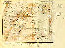
(No Preface) | ||
|
Literature Cited:
Other articles:
|
Junction: Nipton Road, west to US Interstate 15, or east to Nipton. | ||
|
Other articles:
|
Junction: Morning Star Mine Road, west to Cima. | ||
|
Other articles:
|
Junction: Power Line Road | ||
|
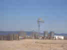
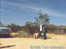
Locations: Ivanpah (#3). |
Ivanpah | ||
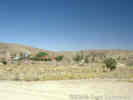
 Castle Mountains Mine as seen from Ivanpah Road Castle Mountains Mine as seen from Ivanpah Road
|
One of the several places called "Ivanpah" is the Ivanpah Road crossing of the Union Pacific Railroad. | ||
|
Other articles:
Locations:
Barnwell.
|
BarnwellJunction: Hart Mine RoadOriginally the headquarters of the Briggs and Murphy Ranch. Joined with other ranches into the Rock Springs Land and Cattle Company in 1894. The site of Barnwell was reached by the Nevada Southern Railway in 1893. At that time the site was named Manvel for the current president of the Santa Fe railroad. The railroad was reorganized as the California Eastern Railway in 1895, and the branch line to Searchlight built in 1906-1907. The name of this site was changed to Barnwell in 1907, named for a telegraph operator stationed there by the railroad company. | ||
|
Other articles:
Locations:
New York Mountains.
|
|||
|
Other articles:
Locations: Keystone Canyon. |
Junctions: Keystone Canyon | ||
|
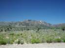
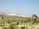
Other articles:
Locations:
Castle Peaks.
|
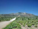
Castle Peaks to the north east. | ||
|
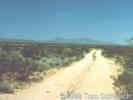
Other articles:
|
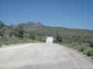
Looking north on Ivanpah Road. | ||
|
Other articles:
Locations:
New York Mountains.
|
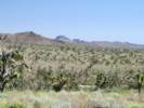
View of the New York Mountains to the west. | ||
|
Literature Cited:
Other articles:
|
near Purdy
| ||
|
Other articles:
|
Junction: Sagamore Canyon Road | ||
|
Locations: Purdy. |
PurdyRailroad station, 4 miles southeast of Barnwell, on the Ivanpah 1912 quadrangle, elevation 4524 ft. | ||
|
Literature Cited:
Other articles:
Locations: Jacoby Ranch. Ledge. Maruba P. O.. |
OX Ranch
The headquarters of the OX Ranch is on Ivanpah Road, at the intersection with New York Mountain Road. This location has also been known as "Ledge," a station on the Atchison, Topeka and Santa Fe Railroad, and " Maruba," which seems to have been the name of a post office (Thompson, 1920). It was at Ledge that Annie Alexander and Louise Kellogg were directed to the south side of the New York Mountains because the road to Keystone Canyon was washed out. Annie and Louise made their way to Caruthers Canyon, thinking they were in Fourth of July Canyon, and collected many specimens in May, 1940. Thompson (1921) refers to the ranch here as "Jacoby Ranch." | ||
|
Literature Cited:
Other articles:
Locations: Lanfair. |
Lanfair
There are also several routes from Thompson (1921), Routes to Desert Watering Places in the Mohave Desert Region, that begin, end, or pass through Lanfair:
| ||
| If you have a question or a comment you may write to me at: tomas@schweich.com I sometimes post interesting questions in my FAQ, but I never disclose your full name or address. |
Date and time this article was prepared: 9/22/2024 4:37:41 PM |