Eastern Mojave Vegetation
Tom Schweich
|
Eastern Mojave Vegetation
| Power Line Road |
|
Tom Schweich |

|
(No Preface) |
|
|
National Trails Highway |
|
|
BNSF Railroad |
| Road Junction | |
|
|
Microwave Relay Stn Rd |
|
|
Crucero Road |
| Road Junction | |
|
|
Union Pacific Railroad |
| Railroad crossing. | |
|
|
SandsRailroad station. |
| Road junction. | |
|
Other articles:
|
Road junction, main road rejoins power lines. |
| Road junction, southwest margin of Old Dad Mountain. | |
|
Other articles:
|
|
|
Locations:
Rocky Ridge.
|
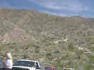
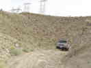
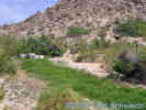
The switchbacks on the power line road are steep, but easy to drive if you take your time. |
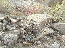 Desert Dudleya in a ravine in the Kelso Mountains. Desert Dudleya in a ravine in the Kelso Mountains.
|
Desert Dudleya (Dudleya saxosa ssp. aloides) along side the Power Line road is three or four adjacent gullies. Not found elsewhere along this road. |
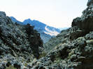
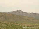
 View of Old Dad Mountain from Rocky Ridge View of Old Dad Mountain from Rocky Ridge
|
This is the view of the southern end of Old Dad Mountain and Jackass Canyon, just before slipping and sliding down the switchbacks. |
|
|
Radar Ridge Roadvia switchbacks |
|
Other articles:
|
Kelbaker Road |
|
Other articles:
Locations:
Kelso Mountains.
|
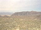
This photograph was taken from the southwest edge of Cima Dome. |
|
Other articles:
Locations:
Kelso Mountains.
|
|
|
Locations:
Marl Spring.
|
Marl Spring RoadMarl Spring was a stop on the Mojave Road. It was the only reliable water between Rock Spring to the east, and Soda Springs to the west.Plaque at Marl Springs reads as follows: "Pozos de San Juan de Dios "On March 8, 1776, Fr. Francis Garces, O.P.M., on his most famous journey of over 2,000 miles from Mission San Xavier del Bac, Tucson, Arizona, to Mission San Gabriel, rested here and named these waterholes "St. John of God Springs," (Marl Springs), and on the return journey passed through here, May 22, same year. "Erected by the Hospitaller Brothers of St. John of God, Saint Mary Desert Valley Hospital, Apple Valley, California, 1972, in cooperation with the San Bernardino County Museum."
|
|
Literature Cited:
Locations:
Cedar Canyon.
Marl Spring.
Rock Spring.
|
Lieutenant A. W. Whipple camped at Marl Springs on March 7-8, 1854. After passing through Cedar Canyon on their way from Rock Spring, Whipple writes, " The spring was small, and their was not more than half enough water for the mules. But as it constantly though slowly flowed in, after awhile the animals were satisfied, and we obtained water for the uses of camp. the grass is highly nutritious. Cactaceae are abundant. Tall and beautiful yuccas, the offensive larrea Mexicana, and obione, complete the list of vegetation." Obione is a synonym for Atriplex. "The day has been windy, cold, and disagreeable." The next morning the spring was filled to the high-water mark, but there was only a moderate amount of water for each mule (Foreman, 1941). |
|
Other articles:
Locations: Rainbow Wells. |
Rainbow Wells Road |
| Road junction. | |
| Road junction. | |
|
Other articles:
|
Cima Road |
|
|
Morningstar Mine Road |
| Road Junction. | |
|
Other articles:
|
Ivanpah Road |
| Road Junction. | |
|
|
Union Pacific Railroad |
| Road Junction | |
|
California above Nevada below. | |
| Road Junction. | |
|
|
Nevada Highway 164 |
| If you have a question or a comment you may write to me at: tomas@schweich.com I sometimes post interesting questions in my FAQ, but I never disclose your full name or address. |
Date and time this article was prepared: 7/13/2024 8:02:50 AM |