Eastern Mojave Vegetation
Tom Schweich
|
Eastern Mojave Vegetation
| The Vegetation of Lobo Point and North Wild Horse Mesa, Mojave National Preserve, San Bernardino County, California. (Continued) |
|
Tom Schweich |

Topics in this Article: Introduction Geography Geology Climate Methods Results Discussion Summary Literature Cited |
|
||||
|
|
MethodsMy field methods include measured plots and line-intercept transects. Additional field data was obtained by a library search for published papers. | ||||
|
Other articles:
|
Measured PlotsThe measured plots reported in this paper are rectangular, one being 1x100m and the other 5x50m. I have also measured two 5m2 quadrats during my study of Frasera albomarginata which are not further discussed in this paper. | ||||
|
Locations: Lobo Point. |
Of the rectangular measured plots, one crosses the the valley floor near the camp site at Lobo Point. The plot is 100 m long and quite narrow, 1 m., and thus might also be termed a "strip transect." | ||||
|
Other articles:
|
The other measured plot is located near the access road to Lobo Point. This transect is 50 m long by 5 m wide. Additional information specific to this transect is available. | ||||
| The methods used for both measured transects are similar. A representative location is chosen by subjective means. A direction is selected, usually along elevation contours. A stake is driven and a 50 m fiberglass tape is unreeled in the chosen direction. This becomes the centerline of the transect and should be as straight as possible. | |||||
| I also have a bar which is as wide as the intended transect. In the case of the narrow transect, 1 m wide, I have a broomstick which is ruled in 10 cm segments. In the case of the wide transect, 5 m wide, I used 1/2" plastic water pipe, in sections, which was also ruled in 10 cm segments. | |||||
| I then successively occupy integer meter locations on the transect, i.e., 0 m, 1 m, 2 m, etc. The "bar" is placed at each location on the bar. | |||||
 Portion of transect data sheet. Portion of transect data sheet.
|
Each plant is identified, and located on the center line and cross bar axes. Dimensions of the plant are determined by a rod (well, actually a broomstick ruled in 10 cm segments). This information is recorded on a data sheet, including a plan-view sketch of the entire transect. | ||||
|
|
Line Intercept TransectsEach plant is identified, its position on the line noted, and the length of line covering the plant is determined. This information is recorded on a data sheet for later analysis. | ||||
|
Locations: Lobo Point. Wild Horse Mesa. |
ChecksheetsI have also developed a cheeksheet which includes all the species commonly found in the Lobo Point and North Wild Horse Mesa area. The checksheet also records identification information, such as location, date and time, rock type, geomorphic process, etc. | ||||
| At selected locations, I will walk a straight line, tallying the species name of every plant I have to step over. It works best to pick a distant object to walk towards. Otherwise, I find walking a straight line very difficult (and this before attitude-adjustment hour!) | |||||
| I continue tallying until somewhere between 20-40 of the most numerous species has been tallied. When multiple species are common, I will stop the checksheet at a fewer number of tallies, while transects with one dominant species generally will have more tallies of the dominant species before stopping. This generally results in a total number of observations between 50 and 80. | |||||
| It is not unusual to see a species close by, but not in the walking path. I will mark their presence with a small mark, but not a tally. | |||||
| At the end of the transect, I will walk a different path back to the starting point. Any species seen, but not previously tallied are noted with a small mark on the check sheet. | |||||
| The checksheet method provides a way to rapidly develop an unbiased estimate of the species present at a location. A checksheet can be completed in about 20 minutes. I have a tendency to perform vegetation analysis by arm-waving from the window of my truck. (And, by the way ... I know I'm not alone in this.) The checksheet method causes me to get out of the truck and actually look at each plant, and to discover that the vegetation is not what it looked like from the truck. | |||||
|
Locations: Columbia Mountain Quadrangle. |
Ultimately, my intent with the checksheet is to have a sample from each of the approximately 154 km2 in the Columbia Mountain quadrangle. I estimate the sampling in the quadrangle to be about 1/3 complete. | ||||
|
|
Library ResearchIn addition, I have also performed good old-fashioned library research. Quantitative data from the work of other researchers have been included into my data set, with appropriate credit given. | ||||
|
Literature Cited:
Locations: Columbia Mountain Quadrangle. Lobo Point. Wild Horse Mesa. |
Summary of Data Set
| ||||
|
|
ResultsTransects from which absolute data can be calculated show the typical density of woody plants and shrubs in this area to be 1.3 plants per square-meter and coverage about 25%. | ||||
|
Locations:
Lobo Point.
|
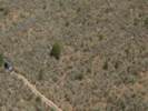
The vegetation at Lobo Point is a desert scrub, consisting of Wild Buckwheat (Eriogonum fasciculatum), Blackbush (Coleogyne ramosissima), Sticky Snakeweed (Gutierrezia microcephala), Ericameria (E. linearifolia and E. cooperi), Buckhorn Cholla (Opuntia acanthocarpa), Nevada Ephedra (Ephedra nevadensis), Turpentine Broom (Thamnosma montana), and Blue Yucca (Yucca baccata). The appearance of this vegetation is shown in Figure 12. | ||||
|
Locations: Mojave Desert. |
The scrub is similar to blackbush scrub, which can be problematic in definition, but is often found in the Mojave Desert above the creosote bush scrub and below the pinyon-juniper woodland. Several species are consistently associated with a wash habitat, particularly Desert Almond (Prunus fasciculata), Woolly Bursage (Ambrosia eriocentra), Purple Sage (Salvia dorrii), Bladder Sage (Salazaria mexicana), and Catclaw (Acacia greggii). | ||||
| A pinyon-juniper woodland, with Pinyon (Pinus monophylla) and Utah Juniper (Juniperus osteosperma), is found in the sheltered north-facing valleys at Lobo Point and North Wild Horse Mesa. Wright's Buckwheat (Eriogonum wrightii), Green Ephedra (Ephedra viridis) and Desert Bitterbrush (Purshia glandulosa) are often found in association with pinyons and junipers. | |||||
|
Locations:
Lobo Point.
Wild Horse Mesa.
|
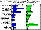
The ranges of density and coverage for species found at Lobo Point and Wild Horse Mesa are shown in Figure 13. | ||||
|
Locations: New York Mountains. Providence Mountains. Wild Horse Mesa. |
A small area on the north slope of Wild Horse Mesa has several species reported previously for the New York Mountains, but not the Providence Mountains or the Mid Hills. They are: Canyon Live Oak (Quercus chrysolepis), Pale Silk-tassel (Garrya flavescens), Single-leaved Ash (Fraxinus anomala), Western Service-berry (Amelanchier utahensis), Holly-leaf Redberry (Rhamnus ilicifolia) and Frasera albomarginata. | ||||
|
Locations: Lobo Point. |
Mohave Yucca (Yucca schidigera) is found at Lobo Point but is apparently at the upper elevational limit of its range. Many other species are found at Lobo Point. A complete plant list is published herein. | ||||
| Following measurement of transects and summarization of data, the next step is to describe the unique species associations. | |||||
|
|
Development of Local Vegetation AssociationsTransect data and a plant list for all locations is published elsewhere. However, it also seems worthwhile to list the species that one would expect to find in specific locations of the study area. In the elevation band that includes Lobo Point and North Wild Horse Mesa, the following associations are fairly obvious: | ||||
| |||||
|
Other articles:
Locations: Lobo Point. |
Lobo Point "Base" VegetationThe Lobo Point "Base" Vegetation is defined as the species found on the alluvial surfaces in the vicinity of Lobo Point, but away from slopes. The type location for this vegetation would be my Location 1 as described in "Transect 5 in Blackbrush Scrub Near Lobo Point, Mojave National Park, California." | ||||
|
Locations: Lobo Point. |
Lobo Point WoodlandI define the Lobo Point Woodland as the washes, benches and slopes to the south and west of the main camp site at Lobo Point. The slopes are oriented to the north and east. Since the Pinyons and Junipers come down into the washes and associated benches, I include those areas in my definition of the area covered by Lobo Point Woodland. This is why there are wash species (e.g., Ambrosia eriocentra) in the list for Lobo Point Woodland association. | ||||
|
Locations: Wild Horse Mesa. |
North Wild Horse Mesa WoodlandThe type area for North Wild Horse Mesa Woodland is defined as the area between the water tank in the valley north of Wild Horse Mesa, up to, but not including, the rim of Wild Horse Mesa. The inclusion or exclusion of the rim of Wild Horse Mesa is important, because Agave desertii and Atriplex canescens grow right at the rim. However, these species are not found below the rim and I have therefore excluded the area. | ||||
| A presence table for species in the three associations follows: | |||||
                              Lobo     Lobo    North Wild
                             Point     Point   Horse Mesa
                              Base   Woodland   Woodland
Species                       Assn     Assn       Assn
Juniperus osteosperma          X         X          X
Ephedra nevadensis             X         X          X
Ephedra viridis                          X          X
Pinus monophylla                         X          X
Rhus trilobata                           X          X
Ambrosia eriocentra            X         X
Brickellia californica                   X
Chrysothamnus sp.                        X
Ericameria cooperi             X         X
Ericameria cuneata                       X
Ericameria linearifolia        X         X          X
Gutierrezia microcephala       X         X          X
Hymenoclea salsola             X         X
Tetradymia stenolepis                    X
Echinocereus engelmannii                 X          X
Echinocereus mohavensis                  X
Escobaria vivipara                       X
Opuntia acanthocarpa           X         X          X
Opuntia basilaris              X         X          X
Atriplex canescens                       X
Acacia greggii                 X         X          X
Dalea searlsiae                                     X
Quercus chrysolepis                                 X
Garrya flavencens                                   X
Frasera albomarginata                               X
Krameria erecta                          X
Salazaria mexicana             X         X
Salvia dorrii                  X         X
Salvia mohavensis                        X
Sphaeralcea ambigua            X         X
Forestiera neomexicana                   X
Corizanthe sp.                 X         X          X
Eriogonum fasciculatum         X         X          X
Eriogonum wrightii                       X          X
Rhamnus ilicifolia                       X          X
Amelanchier utahensis                               X
Coleogyne ramosissima          X         X          X
Fallugia paradoxa                        X
Prunus fasciculata             X         X          X
Purshia glandulosa                       X          X
Thamnosma montana              X         X          X
Castelleja spp.                X         X          X
Penstemon eatonii                        X          X
Datura wrightii                X         X
Lycium andersonii                        X
Lycium cooperi                           X
Yucca baccata                  X         X          X
Yucca schidigera               X         X
Stipa spp.                     X
|
[Previous Page]
[Next Page]
|
If you have a question or a comment you may write to me at:
tomas@schweich.com
I sometimes post interesting questions in my FAQ, but I never disclose your full name or address.
|
|
Date and time this article was prepared: 4/21/2025 8:27:41 PM |