Eastern Mojave Vegetation
No
|
Eastern Mojave Vegetation
| US Highway 191 |
|
No |

|
(No Preface) | |||||||||||||||||||||||||||||||||||||||||||||||||||||||||||||||||||||||||||||||||||||||||||||||||||||||||||||||||||||||||||||||||||||||||||||||||||||||||||||||||||||||||||||||||||||||||||||||||||||||||||||
|
Junction: US Highway 2, west, to Interstate 15 at Shelby, MT, and eventually to US Interstate 5 at Everett, WA. | ||||||||||||||||||||||||||||||||||||||||||||||||||||||||||||||||||||||||||||||||||||||||||||||||||||||||||||||||||||||||||||||||||||||||||||||||||||||||||||||||||||||||||||||||||||||||||||||||||||||||||||||
|
Locations: Milk River. |
Cross Milk River | |||||||||||||||||||||||||||||||||||||||||||||||||||||||||||||||||||||||||||||||||||||||||||||||||||||||||||||||||||||||||||||||||||||||||||||||||||||||||||||||||||||||||||||||||||||||||||||||||||||||||||||
|
Junction: US Highway 2, east to Williston, ND, on the Missouri River. | ||||||||||||||||||||||||||||||||||||||||||||||||||||||||||||||||||||||||||||||||||||||||||||||||||||||||||||||||||||||||||||||||||||||||||||||||||||||||||||||||||||||||||||||||||||||||||||||||||||||||||||||
|
Locations: Malta. |
Malta | |||||||||||||||||||||||||||||||||||||||||||||||||||||||||||||||||||||||||||||||||||||||||||||||||||||||||||||||||||||||||||||||||||||||||||||||||||||||||||||||||||||||||||||||||||||||||||||||||||||||||||||
| Junction: US Interstate 94 | ||||||||||||||||||||||||||||||||||||||||||||||||||||||||||||||||||||||||||||||||||||||||||||||||||||||||||||||||||||||||||||||||||||||||||||||||||||||||||||||||||||||||||||||||||||||||||||||||||||||||||||||
|
|
Bozeman | |||||||||||||||||||||||||||||||||||||||||||||||||||||||||||||||||||||||||||||||||||||||||||||||||||||||||||||||||||||||||||||||||||||||||||||||||||||||||||||||||||||||||||||||||||||||||||||||||||||||||||||
| Junction: US Interstate 94 | ||||||||||||||||||||||||||||||||||||||||||||||||||||||||||||||||||||||||||||||||||||||||||||||||||||||||||||||||||||||||||||||||||||||||||||||||||||||||||||||||||||||||||||||||||||||||||||||||||||||||||||||
| Highway dips into Wyoming for a few miles. | ||||||||||||||||||||||||||||||||||||||||||||||||||||||||||||||||||||||||||||||||||||||||||||||||||||||||||||||||||||||||||||||||||||||||||||||||||||||||||||||||||||||||||||||||||||||||||||||||||||||||||||||
|
|
West Yellowstone, Idaho | |||||||||||||||||||||||||||||||||||||||||||||||||||||||||||||||||||||||||||||||||||||||||||||||||||||||||||||||||||||||||||||||||||||||||||||||||||||||||||||||||||||||||||||||||||||||||||||||||||||||||||||
|
Other articles:
|
Junction: West Entrance Road Yellowstone National Park below
|
Locations: Yellowstone National Park.
| Yellowstone National Park
|
Other articles:
Yellowstone National Park above
| Junction: South Entrance Road
|
| Jackson
|
Other articles:
| Junction: US Highway 26, US Highway 89
See US Highway 26 for commentary from here north to Jackson.
|
Other articles:
| Junction: Wyoming Highway 354, west along the Green River past Old Fort Bonneville Site.
|
| Junction: US Hwy 189, south across the Green River to Daniel, and further south as far as Las Vegas, NV.
|
| Pinedale
|
Other articles:
| FarsonJunction: WY Highway 28, northeast to South Pass and , eventually, Lander.
|
Other articles:
Junction: US Interstate 80
|
|
Locations: Rock Springs.
| Rock Springs
|
Other articles:
Junction: US Interstate 80
|
|
Wyoming above
| Utah below
|
| Dutch John
|
| Cross Flaming Gorge Dam.
|
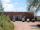
| Flaming Gorge Dam Visitor Center
|
| Cart Creek Bridge
|
| Junction: County Route 183, to Cedar Springs Marina.
|
| Junction: Utah Highway 44, west and north to Manila.
|
Locations: Vernal.
| Vernal
|
| Duchesne
|
Other articles:
Junction: US Highway 6
|
|
Other articles:
Locations: Helper.
| Helper
|
Other articles:
Junction: Utah Highway 10, southwest through Castle Valley to US Interstate 70.
|
|
| Price
|
Other articles:
Junction: Mounds Road
|
|
Other articles:
Locations: Sunnyside Junction.
| Sunnyside Junction
|
Other articles:
Junction: Drill Road
|
|
| Woodside
|
Other articles:
Junction: Green River Cutoff Road
|
|
Other articles:
Junction: US Interstate 70
|
|
Locations: Green River (town).
| Green River
|
Other articles:
| Crescent JunctionJunction: US Interstate 70
|
Other articles:
Just south of Crescent Junction.
|
|
Literature Cited:
Field Trip Stop 1-1 of Demko, et al., 2005.
| This field trip stop is at the northern pinch-out of lacustrine sediments of Mesozoic Lake T'oo'dichi'. The sediments are found in the Brushy Basin member of the Morrison Formation (Upper Jurassic).
|
Literature Cited:
Near this location, just west of the highway are the paleosol collection site in the Morrison and Cedar Mountain Formations used by Retallack in his 2009 study of greenhouse crises of the past 300 million years. Retallack used stomatal index data for fossil Ginko and related leaves as a proxy for past CO2 spikes and paleosol chemical data as proxies for temperature and humidity changes. These data show that global warming due to CO2 rise is a not a unique event in earth history and that the magnitude of the coming anthropogenic greenhouse pales in comparison with past greenhouse spikes at times of global mass extinctions.
|
|
Locations: Courthouse Wash.
Cross Courthouse Wash
| There is a 1913 Marcus E. Jones collection of Frasera paniculata from "Courthouse Wash." From this location, Courthouse Wash descends southeast through Arches National Park, emptying into the Colorado River just north of Moab.
|
Junction: Mill Canyon Road
|
|
Junction: Utah Highway 313, to Dead Horse Point State Park.
|
|
Locations: Colorado River.
Cross Colorado River.
|
|
Other articles:
Junction: Utah Highway 128, east along the Colorado River, emerging from the canyon to join US I 70 near Cisco.
|
|
Locations: Moab.
| Moab
|
Other articles:
| La Sal JunctionJunction: Utah Highway 46, east along the south end of the La Sal Mountains.
|
Junction: Utah Highway 211, west to Canyonlands National Park.
|
|
| Monticello
|
| Blanding
|
Other articles:
Junction: Utah Highway 95, west.
|
|
Literature Cited:
Other articles:
Locations: White Mesa.
| White MesaThere are two collections of Frasera albomarginata described as on a mesa 11 miles north of Bluff. That location is likely White Mesa.
|
Other articles:
Junction: Utah Highway 262, east and then south to Montezuma Creek.
|
|
Literature Cited:
Other articles:
Locations: Bluff.
| Bluff
|
Other articles:
Junction: US Highway 163, southwest past Mexican Hat to US Highway 160 near Kayenta.
|
|
Utah above
| Arizona below
|
Other articles:
Junction: US Highway 160, east to Poplar Bluff, Missouri.
|
|
Other articles:
Locations: Mexican Water.
Junction: US Highway 160, west to US Highway 89 past Tuba City, Arizona. | The settlement of Mexican Water is about 2 miles northwest of this intersection.
|
| Rock Point
|
Other articles:
| Round RockJunction: Indian Reservation Route 12, to the southeast
|
| Chinle
|
Other articles:
Junction: Arizona Highway 264, west.
|
|
Other articles:
Hubbell Trading Post National Historic Site
|
|
Locations: Ganado.
| Ganado
|
Other articles:
Junction: Arizona Highway 264, east, to Window Rock.
|
|
Other articles:
Junction: US Interstate 40, west to Holbrook and Flagstaff.
|
|
|
|
Other articles:
Junction: US Interstate 40, east into New Mexico.
|
|
Locations: Witch Well Trading Post.
Junction: Arizona Highway 61, to Zuni, New Mexico.
|
|
Other articles:
Locations: Witch Well Trading Post.
These sandy bluffs just north of the Zuni River may be the collecting locality for H. D. Ripley and R. C. Barneby collection of Frasera albomarginata (Their #8426. 5/31/1947).
|
|
Locations: Zuni River.
Cross Zuni River.
|
|
Other articles:
Locations: Saint Johns.
| St. JohnsJunction: US Highway 180, northwest to Petrified Forest National Park, and Grand Canyon.
|
Other articles:
There is a nice rest stop just on the northwest edge of Springerville.
|
|
Locations: Springerville.
| Springerville
|
Other articles:
Junction: Arizona Highway 260, west.
|
|
Other articles:
Junction: Forest Road 56, to Escudilla Mountain trailhead.
|
|
Other articles:
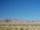
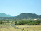
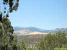
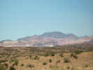
View of countryside west of Alpine.
|
|
Other articles:
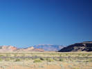
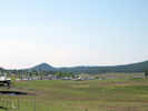
View of Alpine looking southeast toward the town.
|
|
Other articles:
Locations: Alpine.
| AlpineJunction: US Highway 180, east into New Mexico.
|
Other articles:
Junction: Forest Road 26, west to a Frasera speciosa collection locality.
|
|
Other articles:
Locations:
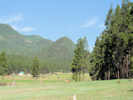
Hannagan Meadow.
| Hannagan Meadow
|
Other articles:
|
|
Strayhorse
|
|
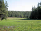
Locations: Four Bar Mesa.
Four Bar Mesa
|
|
Junction: Juan Miller Road, to the east.
|
|
Other articles:
View of Four Bar Mesa to the north.
|
|
Junction: Upper Eagle Creek Road, to the west and then north.
|
|
Metcalf
|
|
Other articles:
Overlook
|
|
Other articles:
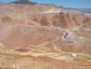
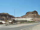
Copper mill above Morenci.
|
|
Locations: Morenci.
| Morenci
|
Other articles:
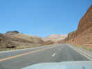
Highway between Clifton and Morenci.
|
|
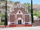
Other articles:
Catholic church in Clifton.
|
|
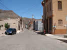
Other articles:
Locations:
Clifton.
| Clifton
|
Other articles:
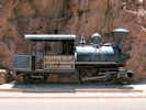
Locomotive on display in Clifton.
|
|
Other articles:
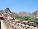
View of rail yard in Clifton.
|
|
Other articles:
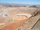
View of Clifton Morenci mines from the south.
|
|
| Three WayJunction, Arizona Highways 75 and 78.
|
| Safford
|
Other articles:
Junction: Arizona Highway 366, to Mount Graham.
|
|
Other articles:
|
|
Other articles:
Junction: US Interstate 10
|
|
| Wilcox
|
Other articles:
Junction: US Interstate 10
|
|
Other articles:
"Sunizona" | Junction: Arizona Highway 181, toward the west side of the Chiricahua Mountains.
|
| Douglas
If you have a question or a comment you may write to me at:
tomas@schweich.com
I sometimes post interesting questions in my FAQ, but I never disclose your full name or address.
|
|
Date and time this article was prepared: 7/13/2024 8:13:33 AM |