Eastern Mojave Vegetation
Tom Schweich
|
Eastern Mojave Vegetation
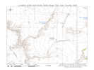
| Utah Highway 95 "Trail of the Ancients" |
|
Tom Schweich |

|
From Hanksville across Lake Powell and into San Juan County, ending near Blanding, Utah. | ||
|
Other articles:
Locations: Hanksville. |
HanksvilleJunction: Utah Highway 24 | ||
|
Other articles:
|
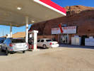
Hollow Mountain Philips 66 gas station. | ||
|
Wayne County above
Garfield County below | |||
|
Locations: Lone Cedar Flat. |
Lone Cedar Flat. There are two collections of Frasera paniculata described as being made 20 miles northwest of Hite. Lone Cedar Flat is about 20 miles northwest of Hite. | ||
|
Other articles:
|
Junction: Utah Highway 267, south to Bullfrog. | ||
| Three Forks. At the junction of Stair Canyon, Butler Canyon, and North Wash. | |||
|
Literature Cited:
Locations: Hog Canyon. |
Hog CanyonIn Hog Canyon is a paleosol collection site in the Permian Rock Point Formation, and in nearby Marinus Canyon is a paleosol collection site in the Permian Church Rock Formation used by Retallack in his 2009 study of greenhouse crises of the past 300 million years. Retallack used stomatal index data for fossil Ginko and related leaves as a proxy for past CO2 spikes and paleosol chemical data as proxies for temperature and humidity changes. These data show that global warming due to CO2 rise is a not a unique event in earth history and that the magnitude of the coming anthropogenic greenhouse pales in comparison with past greenhouse spikes at times of global mass extinctions. | ||
| Hog Canyon Picnic Area | |||
|
Literature Cited:
Locations: Marinus Canyon. |
Marinus Canyon | ||
|
Other articles:
|
|||
|
Literature Cited:
|
Highway Overlook | ||
|
Other articles:
|
|||
|
Literature Cited:
|
Near this location are paleosol collection sites in the Permian Organ Rock Shale and the Triassic Moody Canyon Meber of the Moencopi Formation used by Retallack in his 2009 study of greenhouse crises of the past 300 million years. Retallack used stomatal index data for fossil Ginko and related leaves as a proxy for past CO2 spikes and paleosol chemical data as proxies for temperature and humidity changes. These data show that global warming due to CO2 rise is a not a unique event in earth history and that the magnitude of the coming anthropogenic greenhouse pales in comparison with past greenhouse spikes at times of global mass extinctions. | ||
|
Other articles:
|
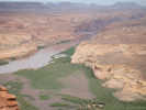
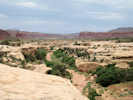
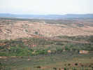
View of Colorado River downstream of the Hite Bridge. | ||
|
Other articles:
|
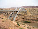
Crossed the Hite Bridge, and then stopped on the north side for this photo. | ||
|
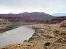
Locations: Colorado River. |
Lake PowellGarfield County aboveSan Juan County below | ||
|
|
Hite | ||
|
Other articles:
|
Junction: Fortknocker Canyon Road (B2081), returns to UT Highway 95 at Ducket Crossing. | ||
|
Other articles:
|
Junction: White Canyon North Road (B2731), east to Fortknocker Canyon Road. Some sources, such as the Delorme Utah Atlas and Yahoo Maps identify this road as "Horse Tanks Road." The real Horse Tanks Road is a short half-mile segment that leads west from Fortknocker Canyon Road to Horse Tanks. | ||
|
Other articles:
|
In the area to the east of Utah Highway 95, there are several collections of Frasera albomarginata. | ||
|
Other articles:
|
Ducket CrossingJunction: Fortknocker Canyon Road (B2081), northeast to Wooden Shoe Road, past Horse Tanks Road, then north and west back to UT Highway 95 close to Hite, Utah, | ||
|
Other articles:
|
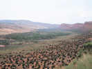
View down White Canyon to the northwest. | ||
|
Other articles:
|
| ||
|
Other articles:
|
Soldier CrossingJunction: Found Mesa Road (B2271)Some maps show this as Horse Tanks Road or Woodenshoe Spur. | ||
|
Other articles:
|
Junction: Utah Highway 276, to Hall's Crossing on the Colorado River. | ||
| Junction: Utah Highway 275, to Natural Bridges National Monument. | |||
|
Other articles:
|
Junction: Utah Highway 261, south to Valley of the Gods and Mexican Hat. | ||
|
Other articles:
|
Comb Creek from highway on west limb of Comb Ridge | ||
|
Other articles:
|
Western limb of Comb Ridge | ||
|
Literature Cited:
Locations: Comb Ridge. |
Comb Ridge | ||
|
Other articles:
|
Junction: US Highway 191, just south of Blanding. | ||
| If you have a question or a comment you may write to me at: tomas@schweich.com I sometimes post interesting questions in my FAQ, but I never disclose your full name or address. |
Date and time this article was prepared: 7/13/2024 8:14:50 AM |