Eastern Mojave Vegetation
Tom Schweich
|
Eastern Mojave Vegetation
| US Highway 160 |
|
Tom Schweich |

Topics in this Article: New Mexico Arizona |
Poplar Bluff, Missouri, to US Highway 89 near Tuba City, Arizona. | ||||||||||||||||||||||||||||||||||||||||||||||||||||||||||||||||||||||||||||||||||||||||||||||||||||||||||||||||||||||||||||||||||||||||||||||||||||||||||||
|
|
Poplar BluffPoplar Bluff, Missouri.Junction: US Highway 60 | ||||||||||||||||||||||||||||||||||||||||||||||||||||||||||||||||||||||||||||||||||||||||||||||||||||||||||||||||||||||||||||||||||||||||||||||||||||||||||||
|
Kansas above
Colorado below | |||||||||||||||||||||||||||||||||||||||||||||||||||||||||||||||||||||||||||||||||||||||||||||||||||||||||||||||||||||||||||||||||||||||||||||||||||||||||||||
|
|
Walsh | ||||||||||||||||||||||||||||||||||||||||||||||||||||||||||||||||||||||||||||||||||||||||||||||||||||||||||||||||||||||||||||||||||||||||||||||||||||||||||||
| Junction: Colorado Highway 100, south to Vilas. | |||||||||||||||||||||||||||||||||||||||||||||||||||||||||||||||||||||||||||||||||||||||||||||||||||||||||||||||||||||||||||||||||||||||||||||||||||||||||||||
|
Other articles:
|
Junction: US Highway 385, north to Lamar, or south to Oklahoma.
|
|
Other articles:
Junction: County Road 12, north, eventually connecting with Colorado Highway 101 runing south from Las Animas.
|
|
Highway turns to southbound from westbound to enter Pritchett. | Comanche National Grasslands below
|
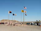
| Pritchett
|
Other articles:
Junction: County Road BB, west from County Road 7, east to County Road 14.
|
|
Cross Lone Rock Draw. There is a collection of Frasera coloradensis about 3-4 miles to the west.
|
|
Other articles:
Junction: County Road Z, west from County Road 5, east to County Road 13.
|
|
Other articles:
Junction: County Road 8, north in the direction of Lone Rock and a collection of Frasera coloradensis.
|
|
Junction: County Road 3, south to Utleyville.
|
|
Las Animas County above
| Baca County below
|
| Andrix
|
Other articles:
Junction: Colorado Highway 109, north to La Junta.
|
|
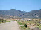
Locations: Kim.
| Kim
|
Comanche National Grasslands above
|
|
| Tobe
|
| Walts CornerJunction: Colorado Highway 398, south to Branson and New Mexico.
|
Other articles:
Junction: US Highway 350, northeast to La Junta.
|
|
Other articles:
Junction: Colorado Highway 12, N. Animas Street
|
|
Other articles:
| TrinidadJunction: US Interstate 25, south.
|
Other articles:
| WalsenburgJunction: US Interstate 25, north.
|
Other articles:
Junction: Main Street, at 5th.
|
|
Other articles:
Junction: Main Street, at 7th
|
|
Other articles:
Locations:
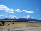
Spanish Peaks.
View of the Spanish Peaks to the south of US Highway 160.
|
|
Other articles:
Junction: CO Highway 12, to La Veta and then south.
|
|
Locations: North La Veta Pass. San Luis Valley.
Huerfano County above
| North La Veta Pass. Costilla County and San Luis Valley below
|
Costilla County above
| Alamosa County below
|
Other articles:
Junction: Colorado Highway 150, north to Great Sand Dunes National Park and Preserve.
|
|
Other articles:
Junction: El Rancho Lane, south to Alamosa National Wildlife Refuge.
|
|
Other articles:
Junction: Colorado Highway 17, north through San Luis Valley to US Highway 285.
|
|
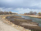
Locations: Rio Grande.
Cross Rio Grande River.
|
|
Other articles:
|
|
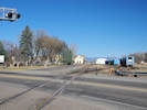
Locations: Alamosa.
| Alamosa
|
Other articles:
|
|
| Parma
|
Other articles:
Junction: N & S 100 Rd | Alamosa County above Rio Grande County below Junction: N CR 6E, S CR 102
|
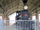
 Monte Vista depot and the San Luis and Rio Grande Railroad. Monte Vista depot and the San Luis and Rio Grande Railroad.
 Colorado Potato Administrative Committee in Monte Vista. Colorado Potato Administrative Committee in Monte Vista.
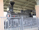
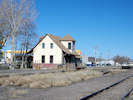 Monte Vista Depot. Monte Vista Depot.
Cross San Luis and Rio Grande Railroad.
|
|
Other articles:
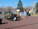
Locations: Monte Vista.
| Monte VistaJunction:
|
| Del Norte
|
Other articles:
Junction: Colorado Highway 112, Oak Street, turn north on Oak Street for Colorado Highway 112, south on Oak Street a block and a half for the Rio Grande County Museum.
|
|
Other articles:
Junction: [Rio Grande] County Road 5 North
|
|
Locations:
Embargo Creek.
Junction: Grainger Road, to Embargo Creek.
|
|
Other articles:
Locations: South Fork.
| South ForkJunction: Colorado Highway 149, north to Creede, Lake City, and US Highway 50 near Gunnison.
|
Locations: San Luis Valley. Wolf Creek Pass.
San Luis Valley and Rio Grande River watershed above
| Wolf Creek Pass, Elev. 10823 ft.
|
Other articles:
Junction: Forest Road 37
|
|
Locations: Coal Creek.
Junction: County Road 113 and Forest Road 666, "Fawn Gulch Road" | About 5 miles east northeast on Coal Creek is a collection locality of Frasera speciosa (Jeanette Flaig 2905, RM160452).
|
Other articles:
Junction: US Highway 84, south into New Mexico
|
|
Other articles:
Locations: Pagosa Springs.
| Pagosa Springs
|
Junction: US Highway 550, south.
|
|
Other articles:
| DurangoJunction: US Highway 550, north.
|
Other articles:
Junction: US Highway 550, south to New Mexico.
|
|
Other articles:
Locations: Mancos.
| MancosJunction: Colorado Highway 184, northwest to Dolores and US Highway 491.
|
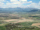
Locations:
Mancos Valley.
View of Mancos Valley from Mesa Verde.
|
|
Literature Cited:
Other articles:
Locations: Mesa Verde. Mesa Verde National Park. Soda Canyon Tip-off Trail.
| Mesa Verde National Park
|
Other articles:
Junction: US Highway 145, north to Dolores, Telluride, and Naturita.
|
|
Other articles:
Locations: Cortez.
| CortezJunction: US Highway 491, north.
|
Other articles:
|
|
Locations: Chimney Rock Draw.
Road east to Chimney Rock Draw.
|
|
Other articles:
Junction: |
|
Other articles:
Junction: Colorado Highway 41, northwest to the Utah State Line and Utah Highway 262, then to Montezuma Creek, Utah
|
|
Colorado above ... | New Mexico below
|
| New Mexico
|
Other articles:
Locations:
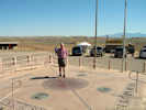
Four Corners.
| Four Corners
|
New Mexico above
| Arizona below
|
| Arizona
|
Other articles:
| Teec Nos PosJunction: Indian Route 5014, to Teec Nos Pos
|
Other articles:
Junction: US Highway 64, southeast to Beclabito, Shiprock, and points east
|
|
Other articles:
Junction: US Highway 191, north.
|
|
Other articles:
Junction: US Highway 191, south.
|
|
Locations: Mexican Water.
Mexican Water is about 2 miles north.
|
|
Other articles:
Junction: US Highway 163, northeast past Kayenta and Mexican Hat to US Highway 191 near Bluff, Utah.
|
|
Literature Cited:
Other articles:
Locations: Tsegi Canyon.
| TsegiMouth of Tsegi Canyon. The southern route of the Old Spanish Trail came from the northeast through present-day Kayenta, and at Tsegi turned northwest through Tsegi Canyon. There are several collections of Muhlenbergia andina (Nutt.) Hitchc. in Tsegi and Betakin Canyons. This grass was first collected by William Gambel in 1841 while traveling on the Old Spanish Trail with the Rowland-Workman party to Los Angeles from Santa Fe, New Mexico. Nuttall (1848b, p. 187) published it as Calamagrostis andina Nutt. giving the location as “ in Upper California, on the Colorado of the West.” Along the southern route of the Old Spanish Trail, Tsegi and Betakin Canyons have the highest concentrations of M. andina of any place along the route near the Colorado River. There is also a collection of Frasera speciosa made about 5 miles up Tsegi Canyon. Access may be easier by way of Navajo National Monument.
|
Junction: Arizona Highway 564, to Navajo National Monument.
|
|
Other articles:
Junction: Arizona Highway 98,
northwest past Kaibito to US Highway 89 just south of Page.
Probably the fastest route to US Interstate near Saint George, Utah.
|
|
Other articles:
Locations: Dark Canyon Plateau.
Junction: Indian Route 16
|
|
Locations: Middle Mesa.
Middle Mesa. | F. W. Gould & W. S. Philips (4741, 7/16/1948) collected Frasera paniculata near here.
|
Other articles:
| Tuba CityJunction: Arizona Highway 264
|
Other articles:
Junction: US Highway 89
|
If you have a question or a comment you may write to me at:
tas4@schweich.com
I sometimes post interesting questions in my FAQ, but I never disclose your full name or address.
|
|
Date and time this article was prepared: 4/27/2024 3:30:07 PM |