Eastern Mojave Vegetation
Tom Schweich
|
Eastern Mojave Vegetation
| U. S. Highway 89 |
|
Tom Schweich |

Topics in this Article: Wyoming Idaho Utah Arizona |
(No Preface) | ||||||||||||||||||||||||||||||||||||||||||||||||||||||||||||||||||||||||||
|
|
US / Canada BorderJunction: Alberta Highway 2Montana below | ||||||||||||||||||||||||||||||||||||||||||||||||||||||||||||||||||||||||||
|
Other articles:
|
Junction: US Interstate 15 at its Exit 278 just outside Great Falls, Montana. | ||||||||||||||||||||||||||||||||||||||||||||||||||||||||||||||||||||||||||
|
|
Great Falls | ||||||||||||||||||||||||||||||||||||||||||||||||||||||||||||||||||||||||||
|
|
Gardiner | ||||||||||||||||||||||||||||||||||||||||||||||||||||||||||||||||||||||||||
|
Other articles:
|
Junction: North Entrance Road Yellowstone National Park below | ||||||||||||||||||||||||||||||||||||||||||||||||||||||||||||||||||||||||||
|
Montana above
| |||||||||||||||||||||||||||||||||||||||||||||||||||||||||||||||||||||||||||
|
|
WyomingWyoming below | ||||||||||||||||||||||||||||||||||||||||||||||||||||||||||||||||||||||||||
|
Locations: Yellowstone National Park. |
Yellowstone National ParkU. S. Highways do not have signage in Yellowstone National Park. For roads in Yellowstone Park see the Entrance Roads and Grand Loop Road. | ||||||||||||||||||||||||||||||||||||||||||||||||||||||||||||||||||||||||||
|
|
West ThumbJunction: US Highway 20, east to Cody. To the south US Highways 89, 191, and 287 are concurrent. | ||||||||||||||||||||||||||||||||||||||||||||||||||||||||||||||||||||||||||
|
Other articles:
|
Yellowstone National Park above
Junction: South Entrance Road | ||||||||||||||||||||||||||||||||||||||||||||||||||||||||||||||||||||||||||
|
|
North Entrance of John D. Rockefeller Jr. National Parkway | ||||||||||||||||||||||||||||||||||||||||||||||||||||||||||||||||||||||||||
|
John D. Rockefeller Jr. National Parkway below | |||||||||||||||||||||||||||||||||||||||||||||||||||||||||||||||||||||||||||
|
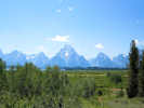
John D. Rockefeller Jr. National Parkway above
Grand Teton National Park below | |||||||||||||||||||||||||||||||||||||||||||||||||||||||||||||||||||||||||||
|
Other articles:
Locations:
Willow Flats.
|
Willow Flats Overlook | ||||||||||||||||||||||||||||||||||||||||||||||||||||||||||||||||||||||||||
|
Other articles:
|
Jackson Lake JunctionJunction: Teton Park Road | ||||||||||||||||||||||||||||||||||||||||||||||||||||||||||||||||||||||||||
|
Other articles:
Locations:
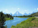
Oxbow Bend.
|
The view from the Oxbow Bend Turnout. | ||||||||||||||||||||||||||||||||||||||||||||||||||||||||||||||||||||||||||
|
This segment is signed for three US Highways: US Highway 89, US Highway 191, and US Highway 287. | |||||||||||||||||||||||||||||||||||||||||||||||||||||||||||||||||||||||||||
|
Other articles:
|
Moran JunctionJunction:
US Highways 89 and 191 are concurrent through Moran Junction. At Moran Junction, US Highways 89, 191, and 287 go north through Yellowstone National Park. US Highways 26, 89, and 191 go south through Jackson and along the Snake River. US Highways 26 and 287 go southeast through the Wind River Range. | ||||||||||||||||||||||||||||||||||||||||||||||||||||||||||||||||||||||||||
|
Locations: Grand Teton National Park. |
Grand Teton National Park | ||||||||||||||||||||||||||||||||||||||||||||||||||||||||||||||||||||||||||
|
|
Moose JunctionJunction: Teton Park Road | ||||||||||||||||||||||||||||||||||||||||||||||||||||||||||||||||||||||||||
| Junction: Gros Ventre Road | |||||||||||||||||||||||||||||||||||||||||||||||||||||||||||||||||||||||||||
|
Grand Teton National Park above
| |||||||||||||||||||||||||||||||||||||||||||||||||||||||||||||||||||||||||||
|
|
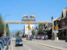
Jackson | ||||||||||||||||||||||||||||||||||||||||||||||||||||||||||||||||||||||||||
|
Junction: US Highway 191, southeast to US I-80 at Rock Springs. | |||||||||||||||||||||||||||||||||||||||||||||||||||||||||||||||||||||||||||
|
Other articles:
|
Alpine JunctionJunction: US Highway 26, to Idaho Falls. | ||||||||||||||||||||||||||||||||||||||||||||||||||||||||||||||||||||||||||
|
Other articles:
Locations:
Afton.
|
Afton | ||||||||||||||||||||||||||||||||||||||||||||||||||||||||||||||||||||||||||
|
Other articles:
Locations:
Salt River Pass.
|
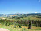
Salt River Pass | ||||||||||||||||||||||||||||||||||||||||||||||||||||||||||||||||||||||||||
|
Wyoming above
| |||||||||||||||||||||||||||||||||||||||||||||||||||||||||||||||||||||||||||
|
|
IdahoIdaho below | ||||||||||||||||||||||||||||||||||||||||||||||||||||||||||||||||||||||||||
|
|
Montpelier | ||||||||||||||||||||||||||||||||||||||||||||||||||||||||||||||||||||||||||
|
Idaho above
| |||||||||||||||||||||||||||||||||||||||||||||||||||||||||||||||||||||||||||
|
|
UtahUtah below | ||||||||||||||||||||||||||||||||||||||||||||||||||||||||||||||||||||||||||
|
Other articles:
|
Garden CityJunction: Utah Highway 30, east to Wyoming and WY Highway 89. | ||||||||||||||||||||||||||||||||||||||||||||||||||||||||||||||||||||||||||
|
Other articles:
|
Junction: N. Main Street, US Highway 91, north through Idaho to the Canada border north of Sweetgrass, Montana.
US Highways 89 and 91 share a route south over Sardine Summit to near Brigham City. | ||||||||||||||||||||||||||||||||||||||||||||||||||||||||||||||||||||||||||
|
|
LoganW. 300 N. | ||||||||||||||||||||||||||||||||||||||||||||||||||||||||||||||||||||||||||
| Junction: W. 200 N., Utah Highway 30, west to US I-15. | |||||||||||||||||||||||||||||||||||||||||||||||||||||||||||||||||||||||||||
| Junction: S. Main St., Utah Highway 165, to South Cache Valley. | |||||||||||||||||||||||||||||||||||||||||||||||||||||||||||||||||||||||||||
|
Other articles:
|
US Highways 89 and 91 share a route northeast over Sardine Summit to Logan.
Junction: US Highway 91, west to US Interstate 15. | ||||||||||||||||||||||||||||||||||||||||||||||||||||||||||||||||||||||||||
|
|
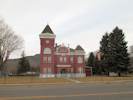
Salt Lake City(Temple St.) | ||||||||||||||||||||||||||||||||||||||||||||||||||||||||||||||||||||||||||
|
Other articles:
|
Junction: US Interstate 80 | ||||||||||||||||||||||||||||||||||||||||||||||||||||||||||||||||||||||||||
| Junction: US I-15, at W 12300 S | |||||||||||||||||||||||||||||||||||||||||||||||||||||||||||||||||||||||||||
Junction: US I-15
|
|
| Spanish Fork
|
Junction: US Highway 6, south west to Price.
|
|
Other articles:
Junction: US Interstate 70, at Exit 56. | Joint route with I-70 southwest to Exit 23 at Sevier
|
Other articles:
Junction: US Interstate 70, by way of the on-ramp labelled UT Hwy 259.
|
|
Other articles:
Junction: Utah Highway 24, just north of Sigurd, in the town of Vermilion.
|
|
| SevierJoint route with I-70 aboveJunction: US Interstate 70, at Exit 23.
|
Other articles:
Locations:
Junction.
| Junction
|
Other articles:
Locations:
Panguitch.
| PanguitchI recommend the Cowboy's Smoke House for Dinner. It will give you an opportunity to wreak vengence on a cow, that probably did the same to the country-side. For breakfast, try Buffalo Java; they have an espresso machine and know how to use it.
|
Other articles:
Junction: Utah Highway 12, east past Bryce Canyon
|
|
Other articles:
| Long Valley JunctionJunction:
|
| Glendale
|
Locations: Orderville.
| Orderville
|
Other articles:
| Mt. Carmel Jct.
|
Other articles:
Locations: Kanab.
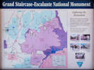
| KanabJunction: US Highway 89 Alternate, south to Fredonia, with access to the north rim of the Grand Canyon.For US Interstate 15 near Saint George, Utah, take US Highway 89A south to Fredonia, Arizona, then Arizona Highway 389 west to Utah Highway 59.
|
Literature Cited:
Near this location about 4 miles east of Kanab (access via Red Hills Road) is a paleosol collection site in the Triassic-Jurassic Moenave Formation used by Retallack in his 2009 study of greenhouse crises of the past 300 million years. Retallack used stomatal index data for fossil Ginko and related leaves as a proxy for past CO2 spikes and paleosol chemical data as proxies for temperature and humidity changes. These data show that global warming due to CO2 rise is a not a unique event in earth history and that the magnitude of the coming anthropogenic greenhouse pales in comparison with past greenhouse spikes at times of global mass extinctions.
|
|
Other articles:
At about six miles east of Kanab, there is a collection of Frasera albomarginata.
|
|
Other articles:
Locations: Buckskin Mountain.
The Buckskin Mountains are to the southeast. There may be a Marcus E. Jones collection of Frasera albomarginata from the Buckskin Mountains.
|
|
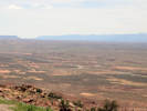
Highway crosses the southern extension of the Cockscomb.
|
|
Cross Paria River
|
|
Literature Cited:
Junction: White House - Trailhead Road | About a mile south on White House - Trailhead Road is a paleosol collection site in the Jurassic Winsor Member of the Carmel Formation used by Retallack in his 2009 study of greenhouse crises of the past 300 million years. Retallack used stomatal index data for fossil Ginko and related leaves as a proxy for past CO2 spikes and paleosol chemical data as proxies for temperature and humidity changes. These data show that global warming due to CO2 rise is a not a unique event in earth history and that the magnitude of the coming anthropogenic greenhouse pales in comparison with past greenhouse spikes at times of global mass extinctions.
|
Other articles:
Junction: Cottonwood Canyon Road, north through Cottonwood Canyon to Kodachrome Basin State Park and Utah Highway 12 at Cannonville.
|
|
Utah above
|
|
| ArizonaArizona below
|
| Page
|
Other articles:
| Junction: Arizona Highway 98, southeast to Kaibito and US Highway 160. This can be a cut-off for travelers to the east like Monument Valley, Utah, or Farmington, New Mexico, because it avoids going south to US Highway 160 near Tuba City, Arizona.
|
Other articles:
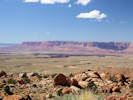
Scenic View of Marble Canyon and Vermilion Cliffs.
|
|
Other articles:
Locations: Bitter Springs.
| Bitter SpringsJunction: US Highway 89-Alternate, generally west past Jacob Lake, to Fredonia, Arizona, and Kanab, Utah. Continuing north on US Highway 89 through Page, Arizona, also passes through Kanab, Arizona. Either route will also lead to US Interstate 15 near Saint George, Utah.
|
Locations: Cedar Ridge.
Frasera albomarginata collected about 1.5 miles west.
|
|
Junction: Indian Reservation Road 20, near The Gap
|
|
Other articles:
Junction: US Highway 160, to Poplar Bluff, Missouri.
|
|
| Cameron
|
Other articles:
| Junction: Arizona Highway 64, west to Grand Canyon.
|
Other articles:
| Junction: Fire Road 545/Loop Rd, east to Wupatki National Monument.
|
Other articles:
Junction: Forest Road 545, west to San Francisco Mountain, east to Sunset Crater Volcanic National Park.
|
|
Other articles:
Junction: County Road 394 "Townsend-Winona Road"
|
|
Other articles:
| FlagstaffEnd of Highway, somewhere in Flagstaff
If you have a question or a comment you may write to me at:
tomas@schweich.com
I sometimes post interesting questions in my FAQ, but I never disclose your full name or address.
|
|
Date and time this article was prepared: 4/21/2025 8:30:06 PM |