Eastern Mojave Vegetation
Paul D. Kilburn and Sally L. White
Jefferson County Nature Association
|
Eastern Mojave Vegetation
| North Table Mountain: Its History and Natural Features |
|
Paul D. Kilburn and Sally L. White |

Topics in this Article: Table of Contents Figures, Tables, Appendices Introduction Physical Characteristics Cultural History Ecological Features Fire History Summary and Recommendations Literature Cited Appendix 1. Plant Species List for North Table Mtn |
Copyright, 1992, Jefferson County Nature Association. Reproduced by permission of the authors. | ||||||||||||||||||||||||||||||||||||||||||||||||||||||||||||||||||||||||||||||||||||||||||||||||||||||||||||||||||||||||||||||||||||||||||||||||||||||||||||||||||||||||||||||||||||||||||||||||||||||
|
Other articles:
|
| ||||||||||||||||||||||||||||||||||||||||||||||||||||||||||||||||||||||||||||||||||||||||||||||||||||||||||||||||||||||||||||||||||||||||||||||||||||||||||||||||||||||||||||||||||||||||||||||||||||||
|
|
Table of Contents
| ||||||||||||||||||||||||||||||||||||||||||||||||||||||||||||||||||||||||||||||||||||||||||||||||||||||||||||||||||||||||||||||||||||||||||||||||||||||||||||||||||||||||||||||||||||||||||||||||||||||
|
|
Figures, Tables, Appendices | ||||||||||||||||||||||||||||||||||||||||||||||||||||||||||||||||||||||||||||||||||||||||||||||||||||||||||||||||||||||||||||||||||||||||||||||||||||||||||||||||||||||||||||||||||||||||||||||||||||||
|
|
List of Figures
| ||||||||||||||||||||||||||||||||||||||||||||||||||||||||||||||||||||||||||||||||||||||||||||||||||||||||||||||||||||||||||||||||||||||||||||||||||||||||||||||||||||||||||||||||||||||||||||||||||||||
|
|
List of Tables
| ||||||||||||||||||||||||||||||||||||||||||||||||||||||||||||||||||||||||||||||||||||||||||||||||||||||||||||||||||||||||||||||||||||||||||||||||||||||||||||||||||||||||||||||||||||||||||||||||||||||
|
Appendix 1: Plant Species List | |||||||||||||||||||||||||||||||||||||||||||||||||||||||||||||||||||||||||||||||||||||||||||||||||||||||||||||||||||||||||||||||||||||||||||||||||||||||||||||||||||||||||||||||||||||||||||||||||||||||
|
Copyright, 1992, Jefferson Co. Nature Association The Jefferson Co. Nature Association is a non-profit organization dedicated to ecological research and public education in Jefferson Co. For more information, contact the association at Jefferson Co. Nature Association, PO Box 593, Morrison Colorado, 80465.
| |||||||||||||||||||||||||||||||||||||||||||||||||||||||||||||||||||||||||||||||||||||||||||||||||||||||||||||||||||||||||||||||||||||||||||||||||||||||||||||||||||||||||||||||||||||||||||||||||||||||
|
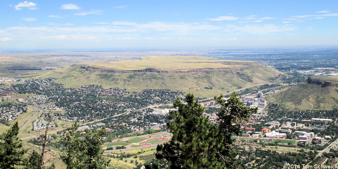
Figure 1. View of North Table Mountain from Lookout Mountain. (This image temporarily replaces the original image in Figure 1 until copyright permission can be sought and obtained.)
| |||||||||||||||||||||||||||||||||||||||||||||||||||||||||||||||||||||||||||||||||||||||||||||||||||||||||||||||||||||||||||||||||||||||||||||||||||||||||||||||||||||||||||||||||||||||||||||||||||||||
|
|
Introduction | ||||||||||||||||||||||||||||||||||||||||||||||||||||||||||||||||||||||||||||||||||||||||||||||||||||||||||||||||||||||||||||||||||||||||||||||||||||||||||||||||||||||||||||||||||||||||||||||||||||||
|
Locations: North Table Mountain. South Table Mountain. |
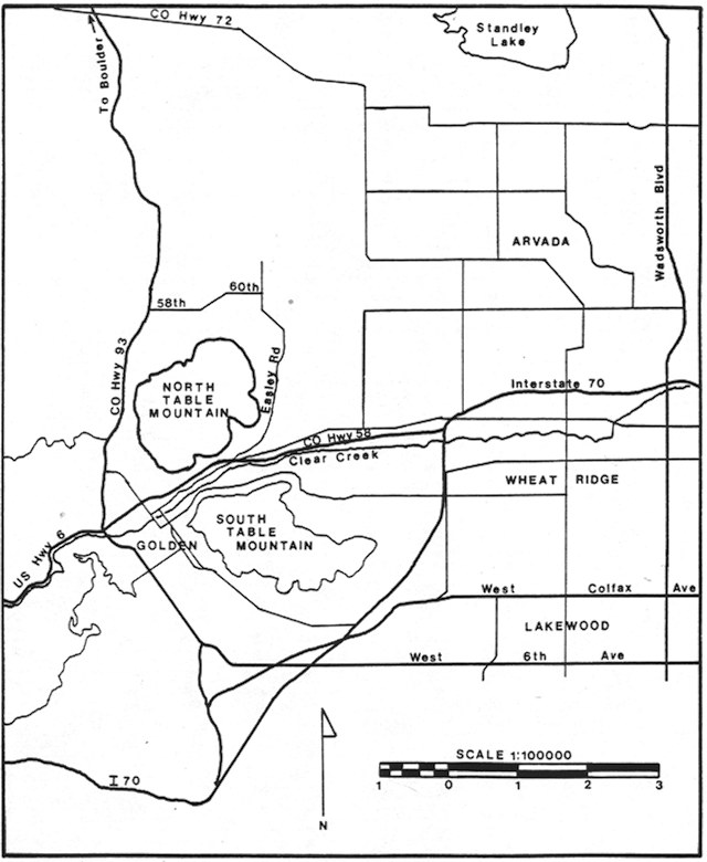
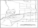
North and South Table Mountains separate Golden from the western portion of the Denver metropolitan area. They have become islands of less disturbed habitat in a highly urbanized area (Figure 1). They are geologically and biologically similar and indeed would be a single mountain had not Clear Creek eroded a channel between them, separating them completely. Figure 2 shows a regional location map of the mountain and surrounding geography. | ||||||||||||||||||||||||||||||||||||||||||||||||||||||||||||||||||||||||||||||||||||||||||||||||||||||||||||||||||||||||||||||||||||||||||||||||||||||||||||||||||||||||||||||||||||||||||||||||||||||
|
The northernmost, North Table Mountain, rises higher than its counterpart, is somewhat smaller and less disturbed, and is capped with three instead of two ancient lava flows. | |||||||||||||||||||||||||||||||||||||||||||||||||||||||||||||||||||||||||||||||||||||||||||||||||||||||||||||||||||||||||||||||||||||||||||||||||||||||||||||||||||||||||||||||||||||||||||||||||||||||
|
North Table Mountain is a flat-topped mountain located a mile east of the Front Range ramparts and stands out as a dominant landmark of the northern plains of Jefferson County. The mountain rises almost 1,000 feet above the surrounding plains and forms a scenic gem, visible for great distances. Its slopes are steep and inhibit access to the top, which has been heavily grazed but largely unplowed. The mountain consequently harbors a native biological diversity increasingly unusual in the urbanized part of northern Jefferson County. | |||||||||||||||||||||||||||||||||||||||||||||||||||||||||||||||||||||||||||||||||||||||||||||||||||||||||||||||||||||||||||||||||||||||||||||||||||||||||||||||||||||||||||||||||||||||||||||||||||||||
|
Literature Cited:
|
Numerous scientific studies have included North Table Mountain in their scope. Several geological studies of the area have been made, culminating in an extensive study by Waldschmidt (1939), which was later updated by Van Horn (1976). A biological study was carried out by Zeise (1976), and much of the information in this paper is drawn from that study. In 1979, as supporting documents for a mine application by Western Paving Construction Co., field studies of cultural resources, geology, soils and other features were made. This report compiles pertinent results of these previous studies for reference. | ||||||||||||||||||||||||||||||||||||||||||||||||||||||||||||||||||||||||||||||||||||||||||||||||||||||||||||||||||||||||||||||||||||||||||||||||||||||||||||||||||||||||||||||||||||||||||||||||||||||
|
No detailed field studies of North Table Mountain have been done to date by the Jefferson County Nature Association, but this report incorporates our observations during field trips from 1988 through 1990, as well as summaries of earlier studies and historical material. In 1992, additional field inventories were conducted by the Colorado Natural Heritage Program. | |||||||||||||||||||||||||||||||||||||||||||||||||||||||||||||||||||||||||||||||||||||||||||||||||||||||||||||||||||||||||||||||||||||||||||||||||||||||||||||||||||||||||||||||||||||||||||||||||||||||
|
This report is a beginning. It summarizes existing information and suggests areas for future study. If North Table Mountain is to continue as a valuable and significant natural feature of northern Jefferson County and retain its present biological diversity, future management of the area will need to incorporate as much information as possible. Recommendations for the potential use of the area as a biological preserve are presented in the summary of this report. | |||||||||||||||||||||||||||||||||||||||||||||||||||||||||||||||||||||||||||||||||||||||||||||||||||||||||||||||||||||||||||||||||||||||||||||||||||||||||||||||||||||||||||||||||||||||||||||||||||||||
 Geographic setting on North Table Mountain. Geographic setting on North Table Mountain.
|
Figure 2. Geographic setting of North Table Mountain. | ||||||||||||||||||||||||||||||||||||||||||||||||||||||||||||||||||||||||||||||||||||||||||||||||||||||||||||||||||||||||||||||||||||||||||||||||||||||||||||||||||||||||||||||||||||||||||||||||||||||
|
|
Physical Characteristics | ||||||||||||||||||||||||||||||||||||||||||||||||||||||||||||||||||||||||||||||||||||||||||||||||||||||||||||||||||||||||||||||||||||||||||||||||||||||||||||||||||||||||||||||||||||||||||||||||||||||
|
|
Geology and Geomorphology | ||||||||||||||||||||||||||||||||||||||||||||||||||||||||||||||||||||||||||||||||||||||||||||||||||||||||||||||||||||||||||||||||||||||||||||||||||||||||||||||||||||||||||||||||||||||||||||||||||||||
|
Literature Cited:
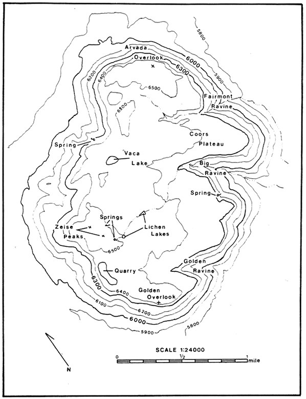
Locations: Arvada Overlook. Golden Overlook. North Table Mountain. Zeise Peaks. |
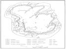
North Table Mountain is about two miles long, one mile wide, and covers an area of approximately 2120 acres (Zeise, 1976) at the base of its steep slopes. The top, a rolling plateau above the steep cliffs, covers an area of about 1000 acres. For reference purposes in this report, we have designated place names as shown on Figure 3. North Zeise Peak is the high point at 6566 feet; the Arvada Overlook on the northeast and Golden Overlook on the southwest also exceed 6500 feet. From these high points the upper plateau slopes southeastward, the northern portion draining to the east and the southern portion to the southeast. | ||||||||||||||||||||||||||||||||||||||||||||||||||||||||||||||||||||||||||||||||||||||||||||||||||||||||||||||||||||||||||||||||||||||||||||||||||||||||||||||||||||||||||||||||||||||||||||||||||||||
|
The flat-topped shape of North Table Mountain results from a lava cap of three flows overlying the softer Denver Formation. In many areas, part of the Denver Formation is between the middle and lowermost basalt layers because of deposition of lava in eroded valleys. These lavas are basaltic, very hard and resistant to erosion, and thus remain perched on softer, more erodible sediments. Steep 30 degree slopes surround the plateau top. | |||||||||||||||||||||||||||||||||||||||||||||||||||||||||||||||||||||||||||||||||||||||||||||||||||||||||||||||||||||||||||||||||||||||||||||||||||||||||||||||||||||||||||||||||||||||||||||||||||||||
|
Literature Cited:
Locations: Ralston Dike. |
The basalt flows probably originated in the Ralston Dike two miles northwest of North Table Mountain (Waldschmidt, 1939) and occurred during the Tertiary Period approximately 35 million years ago. Van Horn (1976) terms the flows latltes and describes them as follows: Flow 1, the lowest and oldest, is confined to North Table Mountain, occurred as tongues in depressions, and is a maximum of 60 feet thick in its central parts; | ||||||||||||||||||||||||||||||||||||||||||||||||||||||||||||||||||||||||||||||||||||||||||||||||||||||||||||||||||||||||||||||||||||||||||||||||||||||||||||||||||||||||||||||||||||||||||||||||||||||
|
Literature Cited:
|
The U.S. Geological Survey has classified these volcanic deposits as the Table Mountain shoshonite (Scott, 1972). Various zeolite minerals occur as filled vesicles in these flows; these have been described by Kile and Modreski (1988). North Table Mountain is a nationally recognized locality for zeolite specimens, which are collected and studied by many students and mineralogists; specimens of local zeolites are on display at the Colorado School of Mines Geology Museum (Modreski, 1992). | ||||||||||||||||||||||||||||||||||||||||||||||||||||||||||||||||||||||||||||||||||||||||||||||||||||||||||||||||||||||||||||||||||||||||||||||||||||||||||||||||||||||||||||||||||||||||||||||||||||||
|
During cooling of the flows, contraction caused formation of vertical joints which are reflected today in the steep cliffs surrounding North Table Mountain. This rim of columnar basalt gives the mountain its characteristic appearance and contributes to its wildlife habitat diversity. | |||||||||||||||||||||||||||||||||||||||||||||||||||||||||||||||||||||||||||||||||||||||||||||||||||||||||||||||||||||||||||||||||||||||||||||||||||||||||||||||||||||||||||||||||||||||||||||||||||||||
|
Literature Cited:
|
Beneath the hard cap of basalt arc the softer claystoncs, arkoses and conglomerates of the Denver Formation. Most of the lower slope is underlain by the Denver and Arapahoe Formations. These weaker sediments erode easily by action of wind, frost or water, undermining the foundation for the overlying jointed flows. Massive blocks of basalt then fall away from the edge of the plateau, littering the slopes with talus debris. Such rockfalls have occurred in recent years, sometimes causing property damage. Weathering of the slopt sediments of the Denver Formastion also forms a soil zone containing swelling clays and a hazardous landslide potential if disturbed by construction activities (Soil Conservation Service, 1980). | ||||||||||||||||||||||||||||||||||||||||||||||||||||||||||||||||||||||||||||||||||||||||||||||||||||||||||||||||||||||||||||||||||||||||||||||||||||||||||||||||||||||||||||||||||||||||||||||||||||||
|
Locations:
Arvada Overlook.
Big Ravine.
Coors Plateau.
Fairmont Ravine.
Golden Overlook.
Golden Ravine.
Lichen Lakes.
Vaca Lake.
Zeise Peaks.
|
Figure 3. Distinctive features and place names for North Table Mountain. | ||||||||||||||||||||||||||||||||||||||||||||||||||||||||||||||||||||||||||||||||||||||||||||||||||||||||||||||||||||||||||||||||||||||||||||||||||||||||||||||||||||||||||||||||||||||||||||||||||||||
|
|
Hydrology | ||||||||||||||||||||||||||||||||||||||||||||||||||||||||||||||||||||||||||||||||||||||||||||||||||||||||||||||||||||||||||||||||||||||||||||||||||||||||||||||||||||||||||||||||||||||||||||||||||||||
|
Locations: Lichen Lakes. Vaca Lake. |
The undulating upper surface has only one natural basin, Vaca Lake, at the northwest corner. Water level in the lake fluctuates as the season progresses, and sometimes the lake dries up completely. Two small artificial impoundments (denoted as Lichen Lakes on Figure 3) have been created, each covering from one to two acres. These serve as summer watering areas for livestock and wildlife, as does Vaca Lake. | ||||||||||||||||||||||||||||||||||||||||||||||||||||||||||||||||||||||||||||||||||||||||||||||||||||||||||||||||||||||||||||||||||||||||||||||||||||||||||||||||||||||||||||||||||||||||||||||||||||||
|
Numerous natural springs occur at the base of the basalt cliffs on all sides of the mountain. In addition to providing sources of water for wildlife, these springs often support mesophytic or hydrophytic vegetation. Zeise (1976) notes the occurrence of tall scouring rush (Hippochaete variegata) at a spring on the south side of the mountain. A dense stand of mountain maple (Acer glabrum) frequently used by mule deer occurs at a spring on the north slope of North Table Mountain. The general southeastern slope of the plateau has produced areas of deeper soils, and often moist permanent seeps, at the heads of the major drainages. | |||||||||||||||||||||||||||||||||||||||||||||||||||||||||||||||||||||||||||||||||||||||||||||||||||||||||||||||||||||||||||||||||||||||||||||||||||||||||||||||||||||||||||||||||||||||||||||||||||||||
|
|
Soil Classification | ||||||||||||||||||||||||||||||||||||||||||||||||||||||||||||||||||||||||||||||||||||||||||||||||||||||||||||||||||||||||||||||||||||||||||||||||||||||||||||||||||||||||||||||||||||||||||||||||||||||
|
Literature Cited:
|
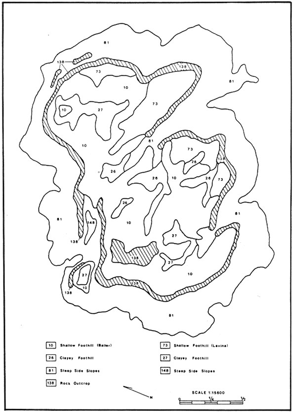
Variations in the depth to the volcanic bedrock produce distinct soil types on the top of North Table Mountain which have been grouped into two main site classifications: Shallow Foothill sites and Clayey Foothill sites. A third type, the Rocky Foothill, is defined by virtual absence of soil over substantial areas of exposed bedrock on the mountaintop, and is also present on the slopes. These same soil types and range sites also occur on South Table Mountain, but are otherwise uncommon in Jefferson County, as is the volcanic substrate from which they are derived. Soil and range site descriptions are from information provided by the Soil Conservation Service (1980). Figure 4 shows the extent and location of these types. Table 1 summarizes the extent and characteristics of the types on the plateau top. | ||||||||||||||||||||||||||||||||||||||||||||||||||||||||||||||||||||||||||||||||||||||||||||||||||||||||||||||||||||||||||||||||||||||||||||||||||||||||||||||||||||||||||||||||||||||||||||||||||||||
|
Table 1. Description of Soil Classification Units
| |||||||||||||||||||||||||||||||||||||||||||||||||||||||||||||||||||||||||||||||||||||||||||||||||||||||||||||||||||||||||||||||||||||||||||||||||||||||||||||||||||||||||||||||||||||||||||||||||||||||
|
The Shallow Foothill range site includes almost 80% of the plateau. The native potential vegetation is predominantly grasses, with big bluestem (Andropogon gerardii), little bluestem (Schizachrium scoparium), sideoats grama (Bouteloua curtipendula) and yellow indiangrass (Sorghastrum nutans) most abundant. These grasses are all highly palatable to cattle, and have been reduced or eliminated over much of North Table Mountain, with a concurrent increase in weedy plants and shrubs. | |||||||||||||||||||||||||||||||||||||||||||||||||||||||||||||||||||||||||||||||||||||||||||||||||||||||||||||||||||||||||||||||||||||||||||||||||||||||||||||||||||||||||||||||||||||||||||||||||||||||
|
The Shallow Foothill site here is a complex of Bailer variant (10) and Lavina (73) soil map units. Both are well drained loams derived from volcanic rock, and are less than ?20 in. deep. Bailer variant soils contain somewhat less clay than Lavina, and predominate on the slopes and ridges. Lavina soils are 20% to 60% clay and have moderate to high shrink-swell potential. These soils are most extensive along the eastern edge of the mesa (Figure 4). | |||||||||||||||||||||||||||||||||||||||||||||||||||||||||||||||||||||||||||||||||||||||||||||||||||||||||||||||||||||||||||||||||||||||||||||||||||||||||||||||||||||||||||||||||||||||||||||||||||||||
|
Literature Cited:
|
Figure 4. Soil types on North Table Mountain, after Soil Conservation Service (1980). Deeper soils (Clayey Foothill Range SiteO occur in drainages. Shallow soils (Shallow Foothill Range Site) predominate on the top. Rock Outcrops (hatched) form the rim, and rocky slopes (Rocky Foothill Range Site) surround the mountain. | ||||||||||||||||||||||||||||||||||||||||||||||||||||||||||||||||||||||||||||||||||||||||||||||||||||||||||||||||||||||||||||||||||||||||||||||||||||||||||||||||||||||||||||||||||||||||||||||||||||||
|
The deeper soils (Clayey Foothill range site, map units 26 and 27) occupy the low areas in which soil has accumulated over the years. The springs, seeps and wetlands on the top of North Table Mountain arc often associated with these deeper soil areas. Potential vegetation for this range site would include mid-grasses such as western wheatgrass (Agropyron smithii), needlegrasses (Stipa spp.), Indian ricegrass (Oryzopsis hymenoides), and blue grama (Bouteloua gracilis). On North Table Mountain, some areas of this range site have been seeded to introduced grasses and are heavily grazed. Because of the deep soils and available water, this is the most productive soil type present on the top. This range site consists of Denver soils, up to 60 in. deep, with 30% to 60% clay and high shrink-swell potential. | |||||||||||||||||||||||||||||||||||||||||||||||||||||||||||||||||||||||||||||||||||||||||||||||||||||||||||||||||||||||||||||||||||||||||||||||||||||||||||||||||||||||||||||||||||||||||||||||||||||||
|
The Rocky Foothill range site on the plateau top (map unit 138) supports the vegetation known as the Lichen-Rock community. Soil, what there is of it, occurs only in small crevices in what is basically an area of exposed latite bedrock. | |||||||||||||||||||||||||||||||||||||||||||||||||||||||||||||||||||||||||||||||||||||||||||||||||||||||||||||||||||||||||||||||||||||||||||||||||||||||||||||||||||||||||||||||||||||||||||||||||||||||
|
The remainder of North Table Mountain consists of rock outcrops and cliffs along the rim (map unit 138), and the steep side slopes (map unit 81). Soil types on these slopes are the Leyden-Primen-Standley extremely stony clay loans, which are characteristic of hill slopes below volcanic mesas. They range from shallow to deep, are well drained, and are characterized by rapid runoff which can create a severe water erosion hazard. Small inclusions of Standley-Leyden-Primen very stony clay loans (map unit 148) occur in areas where soil is reworked by erosion and deposition. Although these slope soils are also part of the Rocky Foothill range site, they are far more productive than the rock outcrop, and are dominated by juniper (Juniperus scopulorum), mountain mahogany (Cercocarpus montanus), and other shrubs, with a mixture of grasses and forbs in the understory. | |||||||||||||||||||||||||||||||||||||||||||||||||||||||||||||||||||||||||||||||||||||||||||||||||||||||||||||||||||||||||||||||||||||||||||||||||||||||||||||||||||||||||||||||||||||||||||||||||||||||
|
|
Cultural History | ||||||||||||||||||||||||||||||||||||||||||||||||||||||||||||||||||||||||||||||||||||||||||||||||||||||||||||||||||||||||||||||||||||||||||||||||||||||||||||||||||||||||||||||||||||||||||||||||||||||
|
|
Presettlement and Historic Use | ||||||||||||||||||||||||||||||||||||||||||||||||||||||||||||||||||||||||||||||||||||||||||||||||||||||||||||||||||||||||||||||||||||||||||||||||||||||||||||||||||||||||||||||||||||||||||||||||||||||
|
Literature Cited:
Locations: North Table Mountain. |
Although heavy Indian use of Jefferson County is well known and documented, there is little evidence of aboriginal use of North Table Mountain. It is logical to assume that it was frequently used for hunting and burial, although probably not generally for year-round living. Many of the solid artifacts, such as arrowheads and tools, were picked up long ago by early settlers and few obvious artifacts remain today. An Indian circle on North Table Mountain was described long ago in a Smithsonian report (Cannon, 1877). | ||||||||||||||||||||||||||||||||||||||||||||||||||||||||||||||||||||||||||||||||||||||||||||||||||||||||||||||||||||||||||||||||||||||||||||||||||||||||||||||||||||||||||||||||||||||||||||||||||||||
Next in importance to the fire-places are what are locally denominated "Indian circles." They are usually constructed of bowlders arranged in the form of a rude circle, about a yard in diameter, with a cavity a foot or two in depth, hollowed out in the center. The most common opinion is that they were used by the indians as fireplaces. The modern indians are said to encamp in sites similar to those in which these circles are found, and in some cases surround their fire with a wall of stones, to prevent them from being extinguished by the wind. Some have supposed that they were occupied by signal-fires, and this may have been the case, as most of them are in situations that would be suitable for the purpose. Again, it has been thought that they mark the graves of some prominent indian warrior or chief, although it was not the usual custom of the Indians to bury their dead, but rather to place the corpse on an elevated platform. | |||||||||||||||||||||||||||||||||||||||||||||||||||||||||||||||||||||||||||||||||||||||||||||||||||||||||||||||||||||||||||||||||||||||||||||||||||||||||||||||||||||||||||||||||||||||||||||||||||||||
One of these circles, on North Table Mountain, appeared so much like a grave, that a party of excursionists made an ineffectual attempt to open it, in hope of finding something to reward their pains, as indians frequently bury utensils and weapons with the dead. The wall surrounding the supposed grave differs from that of other circles in being constructed of flat slaps of basalt, instead of bowlders of quartzose rock, and on the southern size of the inclosure from the crater of an extinct volcano a mile or more distant, and had the appearance of a tombstone. The ground for some distance around gives forth a hollow sound, as if there were a cavity beneath, and on a hill near by is a mound apparently intended as a mark in finding the grave. | |||||||||||||||||||||||||||||||||||||||||||||||||||||||||||||||||||||||||||||||||||||||||||||||||||||||||||||||||||||||||||||||||||||||||||||||||||||||||||||||||||||||||||||||||||||||||||||||||||||||
|
Literature Cited:
|
This was the only documented Indian find on the mountain until the intensive archeological study (Robinson and Benz, 1978) carried out on the southwest portion of the plateau. This study was carried out only on land owned by Western Paving Construction Co., this being about one-quarter of the top of the plateau, and done in conjunction with their application for quarrying this portion. This study discovered only two isolated jasper waste flakes as evidence of possible aboriginal use of the survey area. Although additional archeological studies are needed for the remainder of the area, the long use of the area and easy accessibility suggest that most archeological evidence has long since disappeared. | ||||||||||||||||||||||||||||||||||||||||||||||||||||||||||||||||||||||||||||||||||||||||||||||||||||||||||||||||||||||||||||||||||||||||||||||||||||||||||||||||||||||||||||||||||||||||||||||||||||||
|
The same study did find four recent sites, 50-150 years old, that reveal some use of the area by white man, although these have not been tied directly to particular settlers. The study does mention evidence that an area in Section 22 where deeper soils occur was considered good farmland. | |||||||||||||||||||||||||||||||||||||||||||||||||||||||||||||||||||||||||||||||||||||||||||||||||||||||||||||||||||||||||||||||||||||||||||||||||||||||||||||||||||||||||||||||||||||||||||||||||||||||
Site 1, near the southwestern tip, consisted of a single building foundation about 20 feet by 25 feet constructed of concrete mortar and small rocks. | |||||||||||||||||||||||||||||||||||||||||||||||||||||||||||||||||||||||||||||||||||||||||||||||||||||||||||||||||||||||||||||||||||||||||||||||||||||||||||||||||||||||||||||||||||||||||||||||||||||||
|
Literature Cited:
|
The only known residents on the plateau were Frank Bussert and his son Roy. Manley (1989) interviewed Roy and wrote the following: | ||||||||||||||||||||||||||||||||||||||||||||||||||||||||||||||||||||||||||||||||||||||||||||||||||||||||||||||||||||||||||||||||||||||||||||||||||||||||||||||||||||||||||||||||||||||||||||||||||||||
Frank Bussert ... immigrated to Denver in 1892. He worked at the Tabor Opera House as a carpenter for two to three dollars a day, until the economic depression a year later (the "panic of 1893') when there was no work. In 1894 he homesteaded to North Table Mountain, where he built a stone house eighteen feet by fourteen feet. The family had cows, chickens, pigs, a garden and they hunted wild rabbits and collected wild honey. There were springs and lakes for water, but they had no horses or a wagon. He worked at the brick yard and, eventually, the family acquired over six hundred acres. Frank Bussert died in 1918. | |||||||||||||||||||||||||||||||||||||||||||||||||||||||||||||||||||||||||||||||||||||||||||||||||||||||||||||||||||||||||||||||||||||||||||||||||||||||||||||||||||||||||||||||||||||||||||||||||||||||
|
Roy Frank Bussert remembers a hail storm and flood on 24 July 1896. Their stone house on top of North Table Mountain had more than two inches of water on the floor and he recalled that he was 'scared to death.' He and his brother sat on his mother's lap while she held a parasol in one hand, a Bible in the other and prayed to God to save them. | |||||||||||||||||||||||||||||||||||||||||||||||||||||||||||||||||||||||||||||||||||||||||||||||||||||||||||||||||||||||||||||||||||||||||||||||||||||||||||||||||||||||||||||||||||||||||||||||||||||||
Roy F. Bussert continued to farm with his wife Dolly (Grace) Tripp and, although there was only a 'good' crop about every third year, in 1916 he harvested 1800 bushels of wheat. He also raised turkeys and domesticated coyotes. (The coyote hides sold for three to five dollars apiece and were used for women's furs.) A colony of hawks that nested on the north side of the cliffs sometimes took the chickens and destroyed the wild birds (pheasants, grouse, etc.). | |||||||||||||||||||||||||||||||||||||||||||||||||||||||||||||||||||||||||||||||||||||||||||||||||||||||||||||||||||||||||||||||||||||||||||||||||||||||||||||||||||||||||||||||||||||||||||||||||||||||
|
Roy Bussert lived on the mountain until 1922, when he moved to Golden. | |||||||||||||||||||||||||||||||||||||||||||||||||||||||||||||||||||||||||||||||||||||||||||||||||||||||||||||||||||||||||||||||||||||||||||||||||||||||||||||||||||||||||||||||||||||||||||||||||||||||
|
Literature Cited:
|
Mr. Heine Foss, subsequent landowner, relates that the original Bussert homestead was only about 160 acres (Foss, 1990). They eventually enlarged their holdings to 640 acres which included much of the southern portion of the plateau. | ||||||||||||||||||||||||||||||||||||||||||||||||||||||||||||||||||||||||||||||||||||||||||||||||||||||||||||||||||||||||||||||||||||||||||||||||||||||||||||||||||||||||||||||||||||||||||||||||||||||
|
Mr. Foss also relates that Roy's younger brother Casper told him that the mountain was originally covered with an excellent stand of grass, rich in the native species common to the area. The dense grass was knee high on the cattle and included large amounts of turkeyfoot (big bluestcm), quite a little blue grama and side-oats grama, and some buffalo grass (Buchloe dactyloides). | |||||||||||||||||||||||||||||||||||||||||||||||||||||||||||||||||||||||||||||||||||||||||||||||||||||||||||||||||||||||||||||||||||||||||||||||||||||||||||||||||||||||||||||||||||||||||||||||||||||||
|
Subsequent owners of the mountain heavily overgrazed the grassland. Mr. Foss reports that by 1950, when he purchased much of the mountain, the area had been so heavily overgrazed it supported mainly cheatgrass (Bromus tectorum). Such overgrazing was not unusualat that time it happened throughout the west, creating in some places desert-like vegetation, and allowing heavy erosion to occur. Time and education efforts have helped ranchers generally understand and carry out better grazing practices, which arc much more economical in the long run. | |||||||||||||||||||||||||||||||||||||||||||||||||||||||||||||||||||||||||||||||||||||||||||||||||||||||||||||||||||||||||||||||||||||||||||||||||||||||||||||||||||||||||||||||||||||||||||||||||||||||
|
After his purchase of the land, Mr. Foss embarked on the buildup of the grasslands. The two cultivated wheat fields in Section 22, which after abandonment were almost solely in cheat grass, were replanted with grasses, as was much of the entire range. He embarked on a program of planting $1000 of grass seed per year for more than twenty years. These grasses included tall whcatgrass (Agropyron elongatum) in the lowlands, and intermediate and crested wheatgrass (Agropyron intermedium, A. desertorum) elsewhere. In addition he filled in eroded ditches and gullies to help recreate a more natural landscape, and to support his herd of Purebred Polled Herefords. These were allowed to graze only in the winter. After calving in the early spring, they were taken off the mountain and grazed elsewhere. | |||||||||||||||||||||||||||||||||||||||||||||||||||||||||||||||||||||||||||||||||||||||||||||||||||||||||||||||||||||||||||||||||||||||||||||||||||||||||||||||||||||||||||||||||||||||||||||||||||||||
|
Today grazing is under the control of the major owner, North Table Mountain Corporation, who leases the land for beef cattle grazing. The grazing coincides with the growing season, and the cattle are removed after they have harvested most of the palatable forage. Cattle are placed on top of the plateau in May, graze on the plateau for most of the season, and gradually work their way down the sides in the fall, as the forage on top is eaten. The length of time grazing takes place varies with the season and its productivity. | |||||||||||||||||||||||||||||||||||||||||||||||||||||||||||||||||||||||||||||||||||||||||||||||||||||||||||||||||||||||||||||||||||||||||||||||||||||||||||||||||||||||||||||||||||||||||||||||||||||||
|
Literature Cited:
|
Another use that took place on North Table Mountain has been described as follows (Historically Jeffco, 1989): | ||||||||||||||||||||||||||||||||||||||||||||||||||||||||||||||||||||||||||||||||||||||||||||||||||||||||||||||||||||||||||||||||||||||||||||||||||||||||||||||||||||||||||||||||||||||||||||||||||||||
visible from West 32nd Avenue and Hi 58, looking north across the Coors Brewery to the south face of North Table Mountain, a grove of trees stands alone nearly half way to the top of the flat mesa. Before the turn of the Century, Henry Koch, a German who liked the amusements found in the "Old Country," built an outdoor bowling alley and a dance floor, with rustic tables and chairs alongside the south face of North Table Mountain. On Sundays Koch would insure that kegs of beer were carried to his "beer garden" before people would begin to arrive. By train, wagon, horses and carriages, and often on foot with the purpose of dancing and drinking beer, people came to this mesa. Children would play around the small trees while their parents gossiped, danced, bowled and drank copious amounts of beer. Today the grove of trees marks the place where early Jefferson County Germans remembered their heritage. | |||||||||||||||||||||||||||||||||||||||||||||||||||||||||||||||||||||||||||||||||||||||||||||||||||||||||||||||||||||||||||||||||||||||||||||||||||||||||||||||||||||||||||||||||||||||||||||||||||||||
|
The grove of cottonwood trees and the levelled area remains as a reminder of this early use. | |||||||||||||||||||||||||||||||||||||||||||||||||||||||||||||||||||||||||||||||||||||||||||||||||||||||||||||||||||||||||||||||||||||||||||||||||||||||||||||||||||||||||||||||||||||||||||||||||||||||
|
Literature Cited:
|
Manley (1989) has discussed in considerable detail land use in the area to the east of the mountain but other than the information on the Bussert family, nothing else is noted for the mountain itself. | ||||||||||||||||||||||||||||||||||||||||||||||||||||||||||||||||||||||||||||||||||||||||||||||||||||||||||||||||||||||||||||||||||||||||||||||||||||||||||||||||||||||||||||||||||||||||||||||||||||||
|
|
Mining History | ||||||||||||||||||||||||||||||||||||||||||||||||||||||||||||||||||||||||||||||||||||||||||||||||||||||||||||||||||||||||||||||||||||||||||||||||||||||||||||||||||||||||||||||||||||||||||||||||||||||
|
Literature Cited:
|
The removal of quantities of bulk latite materials has been taking place on North Table Mountain for almost a century and is best termed quarrying, and not mining. The earliest record of such activity was from 1898 and 1899 when a small quarry on the east side of the mountain operated by the School of Mines (Patton, 1900) was opened for the purpose of obtaining zeolite specimens for its mineral collection. These beautiful crystalline structures are described in detail in that article. | ||||||||||||||||||||||||||||||||||||||||||||||||||||||||||||||||||||||||||||||||||||||||||||||||||||||||||||||||||||||||||||||||||||||||||||||||||||||||||||||||||||||||||||||||||||||||||||||||||||||
|
Literature Cited:
|
Manley (1989) notes that shortly thereafter, in 1901, | ||||||||||||||||||||||||||||||||||||||||||||||||||||||||||||||||||||||||||||||||||||||||||||||||||||||||||||||||||||||||||||||||||||||||||||||||||||||||||||||||||||||||||||||||||||||||||||||||||||||
a rock quarry was operated on the top of the mountain. Fred Easley said that a steam crusher was located at the bottom of North Table Mountain and the gravel was hauled to Lakeside by a team of horses. West 44th Avenue was graveled in 1907 or 1908 | |||||||||||||||||||||||||||||||||||||||||||||||||||||||||||||||||||||||||||||||||||||||||||||||||||||||||||||||||||||||||||||||||||||||||||||||||||||||||||||||||||||||||||||||||||||||||||||||||||||||
|
Literature Cited:
|
Foss (1990) recalls more about this quarry, which overlooks Golden on the west side of the plateau where the present large quarry is located. The quarry was run by a man and his son who began the quarry and built a large, deep "glory hole" in which to dump the loose material for subsequent transfer to the tipple, crushers and for loading and hauling off. They used a "sandy andy" system for lowering the rock from the glory hole. This system used two ore cars attached by a cable. When the full one was released, it raised the second to the glory hole for loading; and the procedure was then repeated. The weight of the ore was used to haul the empty car up to be loaded, and the only energy required was for braking. | ||||||||||||||||||||||||||||||||||||||||||||||||||||||||||||||||||||||||||||||||||||||||||||||||||||||||||||||||||||||||||||||||||||||||||||||||||||||||||||||||||||||||||||||||||||||||||||||||||||||
|
One day the glory hole became jammed and the son went in with a crow bar to loosen the rock. In so doing he was trapped with the rock and went through the chute and was killed. The father closed the quarry after that incident. | |||||||||||||||||||||||||||||||||||||||||||||||||||||||||||||||||||||||||||||||||||||||||||||||||||||||||||||||||||||||||||||||||||||||||||||||||||||||||||||||||||||||||||||||||||||||||||||||||||||||
|
Literature Cited:
|
Both Schochow(1978) and Manley (1989) note that a second small quarry, above Highivay 58, was operated in the 1930's, and old roads that probably serviced that activity are still evident. | ||||||||||||||||||||||||||||||||||||||||||||||||||||||||||||||||||||||||||||||||||||||||||||||||||||||||||||||||||||||||||||||||||||||||||||||||||||||||||||||||||||||||||||||||||||||||||||||||||||||
|
Literature Cited:
|
The most significant operation on North Table Mountain was the quarry with the glory hole located on the west side of the mountain (Section 21) described earlier. This quarry was discussed by Argall (1949, p116ff) and described by Schochow as follows: | ||||||||||||||||||||||||||||||||||||||||||||||||||||||||||||||||||||||||||||||||||||||||||||||||||||||||||||||||||||||||||||||||||||||||||||||||||||||||||||||||||||||||||||||||||||||||||||||||||||||
This pit probably was first opened in 1925 by the Golden Basalt Products Company, operated at the time by the Gibbons-Lawrence Construction Company of Denver. Between March and November of 1925, a 120 by 75 foot quarry (0.2 acre) had been developed with a small steep excavation known as a 'glory hole' situated between the main quarry and the rim. Quarried rock dumped into the glory hole proceeded down through an upraise to a loading point. From there the rock was loaded into cars and let down the hillside via surface tramway, the line of which can still be seen due west of the glory bole and terminating at a site on the abandoned railroad grade along Cressman's Gulch just east of Ford Street. In 1925 about 24,430 tons of rock were quarried and processed at a rate of 1974 tons per day and used for concrete aggregate and other purposes. | |||||||||||||||||||||||||||||||||||||||||||||||||||||||||||||||||||||||||||||||||||||||||||||||||||||||||||||||||||||||||||||||||||||||||||||||||||||||||||||||||||||||||||||||||||||||||||||||||||||||
|
Literature Cited:
|
This quarry site was reopened in 1949 and expanded to seven acres by the Ralph Rogers Company of Indianapolis. Quarried rock was trucked down the existing road to a crushing and loading facility at the base, remains of which are still visible. This plant had a capacity of 3000 tons per day, which was the second largest production rate in the state at the time. The crushed stone was shipped to Nebraska via railroad (Schochow, 1978). | ||||||||||||||||||||||||||||||||||||||||||||||||||||||||||||||||||||||||||||||||||||||||||||||||||||||||||||||||||||||||||||||||||||||||||||||||||||||||||||||||||||||||||||||||||||||||||||||||||||||
|
Literature Cited:
|
The quarry and plant operated through 1950. Between 1958 and 1960, other contractors operated the site on a short-term basis. The most recent mining activity on North Table Mountain was in 1976 when Western Paving Construction Co. processed some of the waste rock left by the earlier operations (Schochow, 1978). | ||||||||||||||||||||||||||||||||||||||||||||||||||||||||||||||||||||||||||||||||||||||||||||||||||||||||||||||||||||||||||||||||||||||||||||||||||||||||||||||||||||||||||||||||||||||||||||||||||||||
|
In 1973-1974, the Colorado Geological Survey identified the latites on North and South Table Mountains as two of the very few high quality rock resources along the entire Front Range. These deposits are hard and durable and have potential for use as concrete aggregate, crushed stone for highway construction, and similar uses. | |||||||||||||||||||||||||||||||||||||||||||||||||||||||||||||||||||||||||||||||||||||||||||||||||||||||||||||||||||||||||||||||||||||||||||||||||||||||||||||||||||||||||||||||||||||||||||||||||||||||
|
|
Ecological Features | ||||||||||||||||||||||||||||||||||||||||||||||||||||||||||||||||||||||||||||||||||||||||||||||||||||||||||||||||||||||||||||||||||||||||||||||||||||||||||||||||||||||||||||||||||||||||||||||||||||||
|
|
Vegetation | ||||||||||||||||||||||||||||||||||||||||||||||||||||||||||||||||||||||||||||||||||||||||||||||||||||||||||||||||||||||||||||||||||||||||||||||||||||||||||||||||||||||||||||||||||||||||||||||||||||||
|
Literature Cited:
|
The present vegetation cover of North Table Mountain consists of six basic structural types, within which are often several distinct communities. These major types are summarized below based on descriptions by Zeise (1976), and described in more detail throughout this section. The vegetation map (Figure 5) is adapted from Zeise's report. No new vegetation data have been collected; this report summarizes the original quantitative data and presents additional descriptive information based on our observations. | ||||||||||||||||||||||||||||||||||||||||||||||||||||||||||||||||||||||||||||||||||||||||||||||||||||||||||||||||||||||||||||||||||||||||||||||||||||||||||||||||||||||||||||||||||||||||||||||||||||||
|
Grassland Type
| |||||||||||||||||||||||||||||||||||||||||||||||||||||||||||||||||||||||||||||||||||||||||||||||||||||||||||||||||||||||||||||||||||||||||||||||||||||||||||||||||||||||||||||||||||||||||||||||||||||||
|
Grassland-Shrub Type
| |||||||||||||||||||||||||||||||||||||||||||||||||||||||||||||||||||||||||||||||||||||||||||||||||||||||||||||||||||||||||||||||||||||||||||||||||||||||||||||||||||||||||||||||||||||||||||||||||||||||
|
Shrubland Types
| |||||||||||||||||||||||||||||||||||||||||||||||||||||||||||||||||||||||||||||||||||||||||||||||||||||||||||||||||||||||||||||||||||||||||||||||||||||||||||||||||||||||||||||||||||||||||||||||||||||||
|
Lichen-Rock Type
| |||||||||||||||||||||||||||||||||||||||||||||||||||||||||||||||||||||||||||||||||||||||||||||||||||||||||||||||||||||||||||||||||||||||||||||||||||||||||||||||||||||||||||||||||||||||||||||||||||||||
|
Woodland
| |||||||||||||||||||||||||||||||||||||||||||||||||||||||||||||||||||||||||||||||||||||||||||||||||||||||||||||||||||||||||||||||||||||||||||||||||||||||||||||||||||||||||||||||||||||||||||||||||||||||
|
Riparian
| |||||||||||||||||||||||||||||||||||||||||||||||||||||||||||||||||||||||||||||||||||||||||||||||||||||||||||||||||||||||||||||||||||||||||||||||||||||||||||||||||||||||||||||||||||||||||||||||||||||||
 Vegetation types on North Table Mountain, adapted from Zeise (1976). Vegetation types on North Table Mountain, adapted from Zeise (1976).
|
Figure 5. Vegetation types on North Table Mountain, adapted from Zeise (1976). | ||||||||||||||||||||||||||||||||||||||||||||||||||||||||||||||||||||||||||||||||||||||||||||||||||||||||||||||||||||||||||||||||||||||||||||||||||||||||||||||||||||||||||||||||||||||||||||||||||||||
|
|
Description of Vegetation Types | ||||||||||||||||||||||||||||||||||||||||||||||||||||||||||||||||||||||||||||||||||||||||||||||||||||||||||||||||||||||||||||||||||||||||||||||||||||||||||||||||||||||||||||||||||||||||||||||||||||||
|
Literature Cited:
|
The existing vegetation patterns reflect the operation of human influence as an ecological factor through the past. Three of the most important influences are grazing, fire and mining. Mining operations have made intense impacts, but have been confined to limited areas of the south and southwest portions of the upland lathe deposits. Grazing pressure has been more extensive throughout the upland grassland communities for long periods of time, strongly affecting the composition of those types. A secondary effect of grazing on vegetation was due to reseeding following overgrazing. The shrublands have been affected by grazing animals the least, and presently provide food and shelter for deer and other wildlife. Table 2 summarizes cover characteristics of the vegetation types sampled by Zeise (1976). | ||||||||||||||||||||||||||||||||||||||||||||||||||||||||||||||||||||||||||||||||||||||||||||||||||||||||||||||||||||||||||||||||||||||||||||||||||||||||||||||||||||||||||||||||||||||||||||||||||||||
|
Table 2. Characteristics of Major Plant Communities
| |||||||||||||||||||||||||||||||||||||||||||||||||||||||||||||||||||||||||||||||||||||||||||||||||||||||||||||||||||||||||||||||||||||||||||||||||||||||||||||||||||||||||||||||||||||||||||||||||||||||
|
The third major influence is fire, undoubtedly a frequent but largely unknown factor. Observation of both South and North Table Mountains by local residents suggests that fires promote grasses and forbs at the expense of shrubs, and result in increasing extent of grasslands. An extensive 1988 fire on North Table Mountain, described later in this section, strongly supports this idea. | |||||||||||||||||||||||||||||||||||||||||||||||||||||||||||||||||||||||||||||||||||||||||||||||||||||||||||||||||||||||||||||||||||||||||||||||||||||||||||||||||||||||||||||||||||||||||||||||||||||||
Grassland Type | |||||||||||||||||||||||||||||||||||||||||||||||||||||||||||||||||||||||||||||||||||||||||||||||||||||||||||||||||||||||||||||||||||||||||||||||||||||||||||||||||||||||||||||||||||||||||||||||||||||||
|
This most abundant vegetation type, occurring on the flanks and on the mountain top, has been heavily modified by grazing, especially on the plateau. Although the original grassland may have included several distinct types, present day grassland is dominated by two Eurasian annuals, wild alyssum (Alyssum minus) and cheatgrass (Bromus tectorum). Table 3 indicates that over one-third of the plant cover is by these two species. Total vegetation cover is 64.6%; about 55% of this cover is grasses, 45% is forbs. In structure, the grassland community forms a continuous cover 6 in. to 2 ft. in height, except where rock is at or very near the surface and the soils are thin. | |||||||||||||||||||||||||||||||||||||||||||||||||||||||||||||||||||||||||||||||||||||||||||||||||||||||||||||||||||||||||||||||||||||||||||||||||||||||||||||||||||||||||||||||||||||||||||||||||||||||
|
Several grassland communities have been identified in the region, and it is probable that some of these types were present in the presettlement vegetation of the mountain. Based on remaining native species and existing soil types, the grassland may have been a mixed prairie containing both short-grass and mid-grass species. Because of its elevation and proximity to the foothills, North Table Mountain also supports higher-elevation grasses such as Scribner needlegrass (Stipa scribneri). Grasslands on the lower slopes often contain isolated patches of tallgrass prairie species, especially big bluestem (Andropogon gerardii). | |||||||||||||||||||||||||||||||||||||||||||||||||||||||||||||||||||||||||||||||||||||||||||||||||||||||||||||||||||||||||||||||||||||||||||||||||||||||||||||||||||||||||||||||||||||||||||||||||||||||
|
Table 3. Grassland Communities (based on 110 square-meter quadrats)
* includes Kentucky bluegrass (Poa pratensis) and Poa agassiensis. | |||||||||||||||||||||||||||||||||||||||||||||||||||||||||||||||||||||||||||||||||||||||||||||||||||||||||||||||||||||||||||||||||||||||||||||||||||||||||||||||||||||||||||||||||||||||||||||||||||||||
|
Two significant plant community occurrences were identified in 1992. One is a distinct Stipa comata grassland community near the western rim of the mountain; the other is the Lichen-Rock type described later in this section. The Stipa community occupies approximately 30 to 60 acres, with a maximum cover by needle-and-thread grass (Stipa comata) of 60% on 5 to 10 acres. The prominence of this Stipa grassland may be partly due to effects of the 1988 fire. | |||||||||||||||||||||||||||||||||||||||||||||||||||||||||||||||||||||||||||||||||||||||||||||||||||||||||||||||||||||||||||||||||||||||||||||||||||||||||||||||||||||||||||||||||||||||||||||||||||||||
Grassland-Shrub Type | |||||||||||||||||||||||||||||||||||||||||||||||||||||||||||||||||||||||||||||||||||||||||||||||||||||||||||||||||||||||||||||||||||||||||||||||||||||||||||||||||||||||||||||||||||||||||||||||||||||||
|
Literature Cited:
|
As defined, this type occurs where shrub cover within the grassland matrix is significant but less than 50 percent (Zeise, 1976). Grasses and herbaceous plants together provide more cover than shrubs, but shrub cover usually ranges between 25 and 50 percent of the total plant cover. The average shrub cover (Table 4) was about 21 percent. | ||||||||||||||||||||||||||||||||||||||||||||||||||||||||||||||||||||||||||||||||||||||||||||||||||||||||||||||||||||||||||||||||||||||||||||||||||||||||||||||||||||||||||||||||||||||||||||||||||||||
|
The most abundant shrubs are common foothills species, including western snowberry (Symphoricarpos occidentalis), wild plum (Prunus americana), skunkbush sumac (Rhus trilobata), and wax currant (Ribes cereum). Other shrubs present in the sample or observed in the field are mountain mahogany (Cercocarpus montanus), mountain snowberry (Symphoricarpos oreophilus), chokecherry (Prunus virginiana melanocarpa), wild rose (Rosa arkansana), mountain ninebark (Physocarpus monogynus) and golden currant (Ribu aureum). | |||||||||||||||||||||||||||||||||||||||||||||||||||||||||||||||||||||||||||||||||||||||||||||||||||||||||||||||||||||||||||||||||||||||||||||||||||||||||||||||||||||||||||||||||||||||||||||||||||||||
|
This type is confined to the east, south, and west exposures and slopes. On these steep slopes grazing pressure from domestic animals is much reduced, as they primarily graze on the plateau top where they have ready access to water. Deer predominantly browse shrubs on the slopes, but their influence on the vegetation is less. Although they browse many of the shrubs heavily, and often take new growth and reduce shrub size significantly, their browsing rarely eliminates individual shrub species or changes overall community composition. | |||||||||||||||||||||||||||||||||||||||||||||||||||||||||||||||||||||||||||||||||||||||||||||||||||||||||||||||||||||||||||||||||||||||||||||||||||||||||||||||||||||||||||||||||||||||||||||||||||||||
|
The highest cover (13.1%) for any plant in this type is for Kentucky bluegrass (Poa pratensis); the weedy annual cheatgrass (Bromus tectorum) is next in cover (11.0%). Most of the remaining species are perennials typical of the native vegetation, and the cover of alyssum is reduced to 2.5%. | |||||||||||||||||||||||||||||||||||||||||||||||||||||||||||||||||||||||||||||||||||||||||||||||||||||||||||||||||||||||||||||||||||||||||||||||||||||||||||||||||||||||||||||||||||||||||||||||||||||||
|
Table 4. Grassland-Shrub Type
| |||||||||||||||||||||||||||||||||||||||||||||||||||||||||||||||||||||||||||||||||||||||||||||||||||||||||||||||||||||||||||||||||||||||||||||||||||||||||||||||||||||||||||||||||||||||||||||||||||||||
Shrubland Type | |||||||||||||||||||||||||||||||||||||||||||||||||||||||||||||||||||||||||||||||||||||||||||||||||||||||||||||||||||||||||||||||||||||||||||||||||||||||||||||||||||||||||||||||||||||||||||||||||||||||
|
Shrubs cover much of the flanks of North Table Mountain and form the second most extensive vegetation type on the mountain. Shrubs are often very dense, providing from 30 to 80 percent cover. The six major shrub species (Table 5) are the same as those in the Grassland-Shrub type and form the bulk of the cover. Shrubs range in height and breadth from two to four feet in this type. | |||||||||||||||||||||||||||||||||||||||||||||||||||||||||||||||||||||||||||||||||||||||||||||||||||||||||||||||||||||||||||||||||||||||||||||||||||||||||||||||||||||||||||||||||||||||||||||||||||||||
|
Literature Cited:
|
The proportions of shrub species vary directly with slope, aspect and soil depth. Five major communities, listed in order of extent, can be visually distinguished: mixed shrub; mountain mahogany; mountain mahogany-snowberry, skunkbush-snowberry, and chokecherry-wild plum. Zeise (1976) obtained plant cover data in the two most extensive of these communities: mixed shrub and mountain mahogany. The other shrub communities are not covered in detail here. | ||||||||||||||||||||||||||||||||||||||||||||||||||||||||||||||||||||||||||||||||||||||||||||||||||||||||||||||||||||||||||||||||||||||||||||||||||||||||||||||||||||||||||||||||||||||||||||||||||||||
|
Mixed Shrub Community | |||||||||||||||||||||||||||||||||||||||||||||||||||||||||||||||||||||||||||||||||||||||||||||||||||||||||||||||||||||||||||||||||||||||||||||||||||||||||||||||||||||||||||||||||||||||||||||||||||||||
|
The mixed shrub community (Table 5) covers extensive portions of the slopes and virtually every directional aspect with the exception of the steep northeastern flank, where it is replaced by the mountain mahogany-snowberry community. On steeper southwestern slopes, it is replaced by the Grassland-Shrub type, but persists where the topography is more level. The three major species in this type are snowberry, rarely more than 12 to 18 inches tall, with 33% cover; mountain mahogany with almost 20% cover; and skunkbush or threeleaf sumac with more than 18% cover. The three next most prevalent shrubs are less common: wax currant (5%), wild plum (2%), and chokecherry (13%). Cover by other shrubs within the plots totalled 1.5%; species include mountain maple, mountain ninebark, and wild rose. | |||||||||||||||||||||||||||||||||||||||||||||||||||||||||||||||||||||||||||||||||||||||||||||||||||||||||||||||||||||||||||||||||||||||||||||||||||||||||||||||||||||||||||||||||||||||||||||||||||||||
|
The shrub cover in the mixed shrub community was very high (81.2%), reflecting the dense aspect of these shrubs and their very close spacing. The herbaceous cover in the mixed shrub subtype is primarily of two exotic grasses: Kentucky bluegrass (Poa pratensis) and cheatgrass (Bromus tectorum). These species dominate the Grassland-Shrub type as well. Their presence in this more natural vegetation type probably indicates that an early season growth niche was not occupied by a native species. The species with third highest cover is also prevalent in the Grassland-Shrub type: slender wheatgrass (Agropyron trachycaulum) has 6.7% cover. | |||||||||||||||||||||||||||||||||||||||||||||||||||||||||||||||||||||||||||||||||||||||||||||||||||||||||||||||||||||||||||||||||||||||||||||||||||||||||||||||||||||||||||||||||||||||||||||||||||||||
|
Table 5. Mixed Shrub Community
| |||||||||||||||||||||||||||||||||||||||||||||||||||||||||||||||||||||||||||||||||||||||||||||||||||||||||||||||||||||||||||||||||||||||||||||||||||||||||||||||||||||||||||||||||||||||||||||||||||||||
Mountain Mahogany Community | |||||||||||||||||||||||||||||||||||||||||||||||||||||||||||||||||||||||||||||||||||||||||||||||||||||||||||||||||||||||||||||||||||||||||||||||||||||||||||||||||||||||||||||||||||||||||||||||||||||||
|
The second most abundant shrub community is the pure mountain mahogany community. It is confined to the plateau, forming borders around the western edges where it is almost continuous, and occurring sporadically elsewhere. It is an open shrub-grassland with the shrubs 3 to 5 ft. in height and with dense grassland between the scattered shrubs. In no case does this community extend far from the mountain rims. Its distribution appears as if mountain mahogany spilled over from a richer mixed shrub type on the slopes; rarely do any other shrub species occur within this type. Table 6 indicates that average cover for mountain mahogany is 28.7%; cover by grasses and other herbaceous plants is 65.7%. Thus, this community is far more open than the mixed shrub community, primarily because of the open nature of growth of mountain mahogany, and probably also from graving disturbance. | |||||||||||||||||||||||||||||||||||||||||||||||||||||||||||||||||||||||||||||||||||||||||||||||||||||||||||||||||||||||||||||||||||||||||||||||||||||||||||||||||||||||||||||||||||||||||||||||||||||||
|
Primary understory plants are wild alyssum and chcatgrass. These species occur in similar percentages as in the grassland types. These figures substantiate that heavy grazing pressure exerted over the plateau top has resulted in predominance by Eurasian annuals, in contrast to the dominance by perennial grasses on the slopes shown in Tables 2 and 3. | |||||||||||||||||||||||||||||||||||||||||||||||||||||||||||||||||||||||||||||||||||||||||||||||||||||||||||||||||||||||||||||||||||||||||||||||||||||||||||||||||||||||||||||||||||||||||||||||||||||||
|
Table 6. Mountain Mahogany Community
| |||||||||||||||||||||||||||||||||||||||||||||||||||||||||||||||||||||||||||||||||||||||||||||||||||||||||||||||||||||||||||||||||||||||||||||||||||||||||||||||||||||||||||||||||||||||||||||||||||||||
Lichen-Rock Type | |||||||||||||||||||||||||||||||||||||||||||||||||||||||||||||||||||||||||||||||||||||||||||||||||||||||||||||||||||||||||||||||||||||||||||||||||||||||||||||||||||||||||||||||||||||||||||||||||||||||
|
Locations: Zeise Peaks. |
The Lichen-Rock type or community covers a significant area at the highest portion of the plateau, the area surrounding Zeise Peaks. This unique high part of the uppermost latite layer was once considered the source of the latitc flows. With extensive exposed rock and very shallow soils where the rock is not exposed, this area maintains only 12.6% cover by higher plants (Table 7). The scarcity of other plants makes cover by foliose and crustose lichens very conspicuous. Table 7 summarizes plot data for this type. | ||||||||||||||||||||||||||||||||||||||||||||||||||||||||||||||||||||||||||||||||||||||||||||||||||||||||||||||||||||||||||||||||||||||||||||||||||||||||||||||||||||||||||||||||||||||||||||||||||||||
|
Table 7. Lichen-Rock Type
| |||||||||||||||||||||||||||||||||||||||||||||||||||||||||||||||||||||||||||||||||||||||||||||||||||||||||||||||||||||||||||||||||||||||||||||||||||||||||||||||||||||||||||||||||||||||||||||||||||||||
Woodland Type | |||||||||||||||||||||||||||||||||||||||||||||||||||||||||||||||||||||||||||||||||||||||||||||||||||||||||||||||||||||||||||||||||||||||||||||||||||||||||||||||||||||||||||||||||||||||||||||||||||||||
|
As mentioned earlier, three ecologically distinct communities comprise the woodland type. No data on composition arc available for these communities. | |||||||||||||||||||||||||||||||||||||||||||||||||||||||||||||||||||||||||||||||||||||||||||||||||||||||||||||||||||||||||||||||||||||||||||||||||||||||||||||||||||||||||||||||||||||||||||||||||||||||
|
Mountain Maple Community | |||||||||||||||||||||||||||||||||||||||||||||||||||||||||||||||||||||||||||||||||||||||||||||||||||||||||||||||||||||||||||||||||||||||||||||||||||||||||||||||||||||||||||||||||||||||||||||||||||||||
|
In structure, this is a dense community of small trees from 8 to 12 ft. in height. The dominant species is mountain maple (Acer glabrum), but a wide variety of the shrub species present in the mixed shrub type often form a dense understory. This community is restricted to small, protected pockets just below latitc cliffs or in portions of ravines with better moisture conditions. It is confined primarily to the north and east slopes. | |||||||||||||||||||||||||||||||||||||||||||||||||||||||||||||||||||||||||||||||||||||||||||||||||||||||||||||||||||||||||||||||||||||||||||||||||||||||||||||||||||||||||||||||||||||||||||||||||||||||
|
Cottonwood Woodland Community | |||||||||||||||||||||||||||||||||||||||||||||||||||||||||||||||||||||||||||||||||||||||||||||||||||||||||||||||||||||||||||||||||||||||||||||||||||||||||||||||||||||||||||||||||||||||||||||||||||||||
|
Locations: Big Ravine. Fairmont Ravine. |
Scattered cottonwoods occur along permanent and intermittent streams in several places in ravines and at the heads of ravines. The Fairmount Ravine on the plateau has several 15- to 25-ft. trees scattered along the intermittent streambed, probably indicating a greater presence there in the past. In Big Ravine, where this woodland is best developed, boxelder (Acer negundo) and peach-leaved and coyote willows (Salix amygdaloides, S. exigua) also occur. | ||||||||||||||||||||||||||||||||||||||||||||||||||||||||||||||||||||||||||||||||||||||||||||||||||||||||||||||||||||||||||||||||||||||||||||||||||||||||||||||||||||||||||||||||||||||||||||||||||||||
|
The structure of the community is an open and interrupted woodland with some trees reaching 20 to 30 ft. in height. The largest trees found include Sargent and narrowleaf cottonwoods (Populus sargentii, P. angustifolia), boxelder, and peach-leaved willow. Coyote willow and other shrubs, notably snowberry, often form a dense understory. | |||||||||||||||||||||||||||||||||||||||||||||||||||||||||||||||||||||||||||||||||||||||||||||||||||||||||||||||||||||||||||||||||||||||||||||||||||||||||||||||||||||||||||||||||||||||||||||||||||||||
|
Juniper Savanna Community | |||||||||||||||||||||||||||||||||||||||||||||||||||||||||||||||||||||||||||||||||||||||||||||||||||||||||||||||||||||||||||||||||||||||||||||||||||||||||||||||||||||||||||||||||||||||||||||||||||||||
|
Locations: Big Ravine. |
This community consists of widely scattered upright junipers up to 15 ft. tall set in a dense grassland. Rocky Mountain juniper (Juniperus scopulorum) is the only tree, and typical grassland forms the bulk of the community. These stands are confined to the south slopes where they occur on a few of the most exposed areas. The biggest stand is on the southwest-facing slope at the head of the Big Ravine just below the plateau. | ||||||||||||||||||||||||||||||||||||||||||||||||||||||||||||||||||||||||||||||||||||||||||||||||||||||||||||||||||||||||||||||||||||||||||||||||||||||||||||||||||||||||||||||||||||||||||||||||||||||
|
Literature Cited:
|
Historically, this community appears little changed over the past century. The only photograph we have seen, taken about 1910 (Manley, 1989), shows about the same number of junipers as we see today. Ground fires destroy junipers and probably account for their open savanna growth pattern. The fire in 1988 killed about 20% of the junipers in Big Ravine. | ||||||||||||||||||||||||||||||||||||||||||||||||||||||||||||||||||||||||||||||||||||||||||||||||||||||||||||||||||||||||||||||||||||||||||||||||||||||||||||||||||||||||||||||||||||||||||||||||||||||
Floristics | |||||||||||||||||||||||||||||||||||||||||||||||||||||||||||||||||||||||||||||||||||||||||||||||||||||||||||||||||||||||||||||||||||||||||||||||||||||||||||||||||||||||||||||||||||||||||||||||||||||||
|
Literature Cited:
|
We know of no complete floristic inventory of North Table Mountain to date. Over the past several years, a list of plant species observed on the mountain during various field trips has been recorded. This list is presented in Appendix 1. Taxonomy follows Weber (1976) for consistency with earlier studies. | ||||||||||||||||||||||||||||||||||||||||||||||||||||||||||||||||||||||||||||||||||||||||||||||||||||||||||||||||||||||||||||||||||||||||||||||||||||||||||||||||||||||||||||||||||||||||||||||||||||||
|
Literature Cited:
|
For several years, Loraine Yeatts has been conducting a floristic inventory of South Table Mountain (Yeatts, unpubl.). In a list of more than 300 species, she has documented many species that have not yet been noted for North Table Mountain, which in turn has several species, especially of wetland plants, not yet recorded on South Table Mountain. Because of its unusual character, formal floristic study of North Table Mountain should be undertaken in the future. | ||||||||||||||||||||||||||||||||||||||||||||||||||||||||||||||||||||||||||||||||||||||||||||||||||||||||||||||||||||||||||||||||||||||||||||||||||||||||||||||||||||||||||||||||||||||||||||||||||||||
|
|
Wildlife | ||||||||||||||||||||||||||||||||||||||||||||||||||||||||||||||||||||||||||||||||||||||||||||||||||||||||||||||||||||||||||||||||||||||||||||||||||||||||||||||||||||||||||||||||||||||||||||||||||||||
|
|
Birds | ||||||||||||||||||||||||||||||||||||||||||||||||||||||||||||||||||||||||||||||||||||||||||||||||||||||||||||||||||||||||||||||||||||||||||||||||||||||||||||||||||||||||||||||||||||||||||||||||||||||
|
Locations: Big Ravine. Vaca Lake. |
A wide variety of birds utilizes North Table Mountain for shelter, breeding, wintering, and foraging at various times of the year. The large list of species observed reflects the diversity of foothills habitat, as well as a relative lack of human disturbance. The plant habitats described in the earlier sections range from upland grassland, riparian ravines, and shrublands to vertical cliffs. All habitats are used by different species for breeding with a minimum of overlap, mostly for foraging. In addition to the slope and vegetational differences, three habitats assume key importance for nesting and protection: extensive rock cliffssome with more than 100 ft. of vertical exposure, the large forested valley (Big Ravine) trending southeast, and the lake habitat provided by the upland reservoirs and Vaca Lake. | ||||||||||||||||||||||||||||||||||||||||||||||||||||||||||||||||||||||||||||||||||||||||||||||||||||||||||||||||||||||||||||||||||||||||||||||||||||||||||||||||||||||||||||||||||||||||||||||||||||||
|
Grassland: This habitat dominates the top of North Table Mountain and much of slopes. It is far from homogeneous, however, and contains many rocky outcrops and, on the slopes, large fallen boulders highly prized as protective habitat and perching areas for many bird species. The most abundant bird species of this habitat are the horned lark, vesper sparrow, western meadowlark, grasshopper sparrow, lark bunting, and lark sparrow, all of which nest on the ground. Small bodies of water that occur sparsely throughout the grassland attract killdeer as breeding species and provide water for other species. | |||||||||||||||||||||||||||||||||||||||||||||||||||||||||||||||||||||||||||||||||||||||||||||||||||||||||||||||||||||||||||||||||||||||||||||||||||||||||||||||||||||||||||||||||||||||||||||||||||||||
|
Shrubland: This type dominates the north slope of the mountain and also occurs scattered throughout the plateau, slopes, and valley sides. The shrubland provides crucial protective habitat for migrants and nesting species. The most abundant nesting species are the rufous-sided and green-tailed towhees. Three warblersthe MacGillivray's and Virginia's warblers, and the yellow-breasted chat nest in this habitat. Although it rarely exceeds three to five feet in height, shrubland is usually very dense and thus affords significant protective cover for the species utilizing this habitat. | |||||||||||||||||||||||||||||||||||||||||||||||||||||||||||||||||||||||||||||||||||||||||||||||||||||||||||||||||||||||||||||||||||||||||||||||||||||||||||||||||||||||||||||||||||||||||||||||||||||||
|
Cliffs: Vertical cliff faces ranging from small cliffs to those having vertical faces rising 100' or more occur on all sides of North Table Mountain. They are pocked by ledges, caves, and overhangs that offer unusual protection to a variety of nesting birds. This habitat is heavily used for breeding by violet-green, cliff, and barn swallows, and other species including the white-throated swift, rock wren, red-tailed hawk, and prairie falcon. The most abundant bird using this habitat is the violet-green swallow. | |||||||||||||||||||||||||||||||||||||||||||||||||||||||||||||||||||||||||||||||||||||||||||||||||||||||||||||||||||||||||||||||||||||||||||||||||||||||||||||||||||||||||||||||||||||||||||||||||||||||
|
Valley: The extensive riparian habitat in the large ravine attracts a wide variety of birds especially where cottonwoods occur. These include the northern oriole, lazuli and indigo buntings, yellow warbler, house finch, and American robin. | |||||||||||||||||||||||||||||||||||||||||||||||||||||||||||||||||||||||||||||||||||||||||||||||||||||||||||||||||||||||||||||||||||||||||||||||||||||||||||||||||||||||||||||||||||||||||||||||||||||||
|
Literature Cited:
|
The species observed and recorded to date are listed in Table 8. This list includes only those species recorded during field trips in the springs of 1988 and 1989 (Emerson and Hanley, 1990), and additional species observed during 1992 inventories. Other species were listed by Zeise (1976) but have not been confirmed. | ||||||||||||||||||||||||||||||||||||||||||||||||||||||||||||||||||||||||||||||||||||||||||||||||||||||||||||||||||||||||||||||||||||||||||||||||||||||||||||||||||||||||||||||||||||||||||||||||||||||
|
Table 8. Bird Species Observed on North Table Mountain
| |||||||||||||||||||||||||||||||||||||||||||||||||||||||||||||||||||||||||||||||||||||||||||||||||||||||||||||||||||||||||||||||||||||||||||||||||||||||||||||||||||||||||||||||||||||||||||||||||||||||
|
Table 8. Bird Species observed on North Table Mountain, continued
| |||||||||||||||||||||||||||||||||||||||||||||||||||||||||||||||||||||||||||||||||||||||||||||||||||||||||||||||||||||||||||||||||||||||||||||||||||||||||||||||||||||||||||||||||||||||||||||||||||||||
| |||||||||||||||||||||||||||||||||||||||||||||||||||||||||||||||||||||||||||||||||||||||||||||||||||||||||||||||||||||||||||||||||||||||||||||||||||||||||||||||||||||||||||||||||||||||||||||||||||||||
|
|
Mammals | ||||||||||||||||||||||||||||||||||||||||||||||||||||||||||||||||||||||||||||||||||||||||||||||||||||||||||||||||||||||||||||||||||||||||||||||||||||||||||||||||||||||||||||||||||||||||||||||||||||||
|
Literature Cited:
|
Became of the diverse habitats and lack of development, North Table Mountain is home to or visited by many large and small mammals. The original study (Zeise, 1976) and several informal field trips to North Table Mountain have produced the following list of observed and expected species. | ||||||||||||||||||||||||||||||||||||||||||||||||||||||||||||||||||||||||||||||||||||||||||||||||||||||||||||||||||||||||||||||||||||||||||||||||||||||||||||||||||||||||||||||||||||||||||||||||||||||
|
Table 9. Observed and Expected Mammals on North Table Mountain
| |||||||||||||||||||||||||||||||||||||||||||||||||||||||||||||||||||||||||||||||||||||||||||||||||||||||||||||||||||||||||||||||||||||||||||||||||||||||||||||||||||||||||||||||||||||||||||||||||||||||
|
Literature Cited:
|
In addition, many other species of small rodents and shrews, as well as several species of bats, are likely to occur on North Table Mountain. In a study of similar habitats on Green Mountain, Armstrong (1979) suggests that several additional species should be found in rocky areas, including the yellow-bellied marmot (Marmota flaviventris), Colorado chipmunk (Eutamias quadrivitattus), golden-mantled ground squirrel (Spermophilus lateralis), and bobcat (Lynx rufus). Small ponds with stable water levels would support the meadow jumping mouse (Zapus hudsonius), dusky shrew (Sorex cinereus), and perhaps muskrat (Ondatra zibethicus). As both these habitat types are present on North Table Mountain, these species may occur there. | ||||||||||||||||||||||||||||||||||||||||||||||||||||||||||||||||||||||||||||||||||||||||||||||||||||||||||||||||||||||||||||||||||||||||||||||||||||||||||||||||||||||||||||||||||||||||||||||||||||||
|
|
Other Vertebrates | ||||||||||||||||||||||||||||||||||||||||||||||||||||||||||||||||||||||||||||||||||||||||||||||||||||||||||||||||||||||||||||||||||||||||||||||||||||||||||||||||||||||||||||||||||||||||||||||||||||||
|
Literature Cited:
Other articles:
|
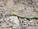
The geologic structure of North Table Mountain, and resulting diversity of habitats, give it a rich fauna. Additional studies are necessary to determine more completely the variety of wildlife species that live there. In particular, reptiles and amphibians have been very little studied. Zeise (1976) includes as possible inhabitants a "blue" racer (probably yellow-bellied racer, Coluber constrictus var. flaviventris), prairie rattlesnake (Crotalus viridis), milk snake (Lampropeltis triangulum) and fence lizard (Sceloporus undulatus). The present relative lack of disturbance, except by cattle, and the rocky habitats make North Table Mountain suitable for an abundance of reptiles.
| ||||||||||||||||||||||||||||||||||||||||||||||||||||||||||||||||||||||||||||||||||||||||||||||||||||||||||||||||||||||||||||||||||||||||||||||||||||||||||||||||||||||||||||||||||||||||||||||||||||||
|
|
Wildlife Summary | ||||||||||||||||||||||||||||||||||||||||||||||||||||||||||||||||||||||||||||||||||||||||||||||||||||||||||||||||||||||||||||||||||||||||||||||||||||||||||||||||||||||||||||||||||||||||||||||||||||||
|
To our knowledge, insect and other invertebrate communities on North Table Mountain have been little studied, and we have no information on them at present. The limited biological studies that have been done suggest that the mountain provides a good reservoir of relatively natural habitat that, because of the limited access, has maintained an abundance of wildlife species that has been eliminated from other low elevation areas where more development is occurring. This is especially apparent in the abundance and diversity of ground-nesting birds that occur on North Table Mountain. Additional studies of the faunal communities should define the significance of this habitat before changes in land use occur. | |||||||||||||||||||||||||||||||||||||||||||||||||||||||||||||||||||||||||||||||||||||||||||||||||||||||||||||||||||||||||||||||||||||||||||||||||||||||||||||||||||||||||||||||||||||||||||||||||||||||
|
|
Fire History | ||||||||||||||||||||||||||||||||||||||||||||||||||||||||||||||||||||||||||||||||||||||||||||||||||||||||||||||||||||||||||||||||||||||||||||||||||||||||||||||||||||||||||||||||||||||||||||||||||||||
|
A major influence on the biota of North Table Mountain has been wildfire, and although no formal documentation is available, observations in the past two decades suggest the significance of fire. Part or all of the vegetation has experienced major fires: in 1977, 1983, and 1988. Where these fires have burned shrub types, they have stimulated the growth of grasses at the expense of shrubs, converting shrublands to grassland vegetation types. Although we can, at this late date, only speculate on the vegetation that existed when the area was settled and the early prevalence of fires, studies of these more recent burns will allow us to understand the relationship of fire and vegetation on the mountain. | |||||||||||||||||||||||||||||||||||||||||||||||||||||||||||||||||||||||||||||||||||||||||||||||||||||||||||||||||||||||||||||||||||||||||||||||||||||||||||||||||||||||||||||||||||||||||||||||||||||||
|
|
September 1988 Burn | ||||||||||||||||||||||||||||||||||||||||||||||||||||||||||||||||||||||||||||||||||||||||||||||||||||||||||||||||||||||||||||||||||||||||||||||||||||||||||||||||||||||||||||||||||||||||||||||||||||||
|
A significant fire occurred on North Table Mountain on September 7-8, 1988. The weeks preceding had been extremely dry, and fire danger throughout Colorado was high. That week several fires broke out in the foothills areas, including one in Left-hand Canyon north of Boulder. | |||||||||||||||||||||||||||||||||||||||||||||||||||||||||||||||||||||||||||||||||||||||||||||||||||||||||||||||||||||||||||||||||||||||||||||||||||||||||||||||||||||||||||||||||||||||||||||||||||||||
|
On the morning of September 7th, a fire started in the weeds east of Highway 93 just north and west of North Table Mountain. From this small beginning, the fire rapidly spread southeast and raced up the northwestern flank of the mountain and across the top. Adjacent fire departments rushed men and equipment to several areas at the base and top of the mountain in order to erect firebreaks and attempt to limit the extent of the fire. The quarry access road on the southwest flank was a major access route and became the location of the firebreak on the west that prevented the fire from burning further south on that side. | |||||||||||||||||||||||||||||||||||||||||||||||||||||||||||||||||||||||||||||||||||||||||||||||||||||||||||||||||||||||||||||||||||||||||||||||||||||||||||||||||||||||||||||||||||||||||||||||||||||||
|
The fire moved quickly across the top in patchwork fashion and headed directly down the Big Ravine, toward the houses on the lower eastern flanks of the mountain. The speed of the fire lessened as it burned downhill and major efforts contained the fire above these houses. Only the vegetation above the houses was burned. | |||||||||||||||||||||||||||||||||||||||||||||||||||||||||||||||||||||||||||||||||||||||||||||||||||||||||||||||||||||||||||||||||||||||||||||||||||||||||||||||||||||||||||||||||||||||||||||||||||||||
|
The fire spread through the afternoon until it essentially ringed the eastern flank of the mountain, then burned slowly downhill to heavily manned firebreaks. On the northeast flank an old access road became the firebreak where the fire was contained. On the southern portion of the eastern flank, the burn line was more irregular, as shown on the map (Figure 6). | |||||||||||||||||||||||||||||||||||||||||||||||||||||||||||||||||||||||||||||||||||||||||||||||||||||||||||||||||||||||||||||||||||||||||||||||||||||||||||||||||||||||||||||||||||||||||||||||||||||||
|
Throughout the evening the fire moved slowly down the eastern and northeastern flanks to the lower points, and by morning it was extinguished in nearly all areas. At this time only the extreme northern flank was unburned. Apparently to eliminate any fire danger in this section, the Fairmount Fire District set this area ablaze from below. A very hot fire swept upward with great speed, consuming the existing shrub vegetation and a lone ponderosa pine. The approximate boundaries of this section are shown on the fire map to indicate the area of higher intensity fire. The greater heat intensity in this area may affect regrowth of vegetation. Had this area remained unburned, it could have served as a comparison area for recovery of the shrubland vegetation types. | |||||||||||||||||||||||||||||||||||||||||||||||||||||||||||||||||||||||||||||||||||||||||||||||||||||||||||||||||||||||||||||||||||||||||||||||||||||||||||||||||||||||||||||||||||||||||||||||||||||||
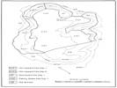 Areas affected by the September 1988 fire on North Table Mountain. Areas affected by the September 1988 fire on North Table Mountain.
|
Figure 6. Areas affected by the September 1988 fire on North Table Mountain. The patchy grassland fire across the top of the plateau was much less intense than fires on the north and west slopes, as delineated here. | ||||||||||||||||||||||||||||||||||||||||||||||||||||||||||||||||||||||||||||||||||||||||||||||||||||||||||||||||||||||||||||||||||||||||||||||||||||||||||||||||||||||||||||||||||||||||||||||||||||||
|
|
Effects of the 1988 Fire | ||||||||||||||||||||||||||||||||||||||||||||||||||||||||||||||||||||||||||||||||||||||||||||||||||||||||||||||||||||||||||||||||||||||||||||||||||||||||||||||||||||||||||||||||||||||||||||||||||||||
|
By the end of the second day, the fire was completely out. Inspection of the flanks showed that nearly all shrubs in the burned area were blackened and the leaves completely consumed by the fire. Grasses and forbs were also burned. Yuccas were burned to the base. A few trees escaped the burn; their green leaves were in dark contrast to the ashy color of the surroundings. | |||||||||||||||||||||||||||||||||||||||||||||||||||||||||||||||||||||||||||||||||||||||||||||||||||||||||||||||||||||||||||||||||||||||||||||||||||||||||||||||||||||||||||||||||||||||||||||||||||||||
|
Inspection of the top immediately after the fire revealed many areas that had not been touched by the fire. Wind direction, roads, firebreaks, ravines or lack of fuel prevented fire damage in spots. The damage to the grasses appeared superficial, as they were already dry at this stage, and the fire apparently burned so rapidly that little damage was done to underground parts. | |||||||||||||||||||||||||||||||||||||||||||||||||||||||||||||||||||||||||||||||||||||||||||||||||||||||||||||||||||||||||||||||||||||||||||||||||||||||||||||||||||||||||||||||||||||||||||||||||||||||
|
Three days later, on the night of the 10th, a gentle rain, measuring almost an inch, fell and soaked into the ground. Within two weeks, on sunny exposures on the west flank, new grass shoots were beginning to come up. Within a month, new grass sprouts produced a distinct green cast over many portions of the mountain, even from a distance. | |||||||||||||||||||||||||||||||||||||||||||||||||||||||||||||||||||||||||||||||||||||||||||||||||||||||||||||||||||||||||||||||||||||||||||||||||||||||||||||||||||||||||||||||||||||||||||||||||||||||
|
Within six weeks of the fire, of occasional sprouting could be seen from the charred shrubs, although the majority showed no life. In June of 1989, shrub mortality was investigated during a followup visit to a badly burned shrubland on the north rim. At that time, apparent shrub mortality was approximately 37% based on examination of 186 shrubs, almost all of which were mountain mahogany. Sprouting was primarily from the base; little or no recovery of burned tops was evident. | |||||||||||||||||||||||||||||||||||||||||||||||||||||||||||||||||||||||||||||||||||||||||||||||||||||||||||||||||||||||||||||||||||||||||||||||||||||||||||||||||||||||||||||||||||||||||||||||||||||||
|
Observations during the spring and summer of 1989 suggest that little long-term damage to the grasslands resulted from the fire. Yuccas were resprouting from the bases, and grass growth was stimulated. The shrublands, however, have been significantly thinned, and the surviving shrubs will require several years to achieve their original height. | |||||||||||||||||||||||||||||||||||||||||||||||||||||||||||||||||||||||||||||||||||||||||||||||||||||||||||||||||||||||||||||||||||||||||||||||||||||||||||||||||||||||||||||||||||||||||||||||||||||||
|
Limited areas of the top were severely damaged by construction of firebreaks. The use of heavy equipment to plow fire lanes disrupted the soil surface and existing vegetation, creating areas that will be slow to recover. | |||||||||||||||||||||||||||||||||||||||||||||||||||||||||||||||||||||||||||||||||||||||||||||||||||||||||||||||||||||||||||||||||||||||||||||||||||||||||||||||||||||||||||||||||||||||||||||||||||||||
|
|
Summary and Recommendations | ||||||||||||||||||||||||||||||||||||||||||||||||||||||||||||||||||||||||||||||||||||||||||||||||||||||||||||||||||||||||||||||||||||||||||||||||||||||||||||||||||||||||||||||||||||||||||||||||||||||
|
The report has to this point discussed the natural history of this plateau that has maintained significant natural character despite its long use and modification by man and proximity to a major metropolitan area. This unusual mountain will require thoughtful management if its present character is to be maintained and enhanced. The surroundings combine to suggest that a natural use of this land could be most beneficial to the people of the region. This section discusses potential uses of the mountain and whether such uses may be appropriate in the future. The most beneficial use may be to maintain the existing character of the plateau through recognition of its value as open space and wildlife habitat. Carefully controlled non-consumptive use of the area, in such a way as to maintain its natural aspect, may provide the greatest longterm value to the regional community. | |||||||||||||||||||||||||||||||||||||||||||||||||||||||||||||||||||||||||||||||||||||||||||||||||||||||||||||||||||||||||||||||||||||||||||||||||||||||||||||||||||||||||||||||||||||||||||||||||||||||
|
|
Agriculture | ||||||||||||||||||||||||||||||||||||||||||||||||||||||||||||||||||||||||||||||||||||||||||||||||||||||||||||||||||||||||||||||||||||||||||||||||||||||||||||||||||||||||||||||||||||||||||||||||||||||
|
North Table Mountain has had more than one hundred years of agricultural uses. Certain portions of the plateau have been plowed and planted to produce crops, but the slopes and shallow soils have allowed only livestock grazing over most of the surface. This grazing has been principally on the plateau as the steep sides are almost prohibitive and unattractive to cattle grazing. | |||||||||||||||||||||||||||||||||||||||||||||||||||||||||||||||||||||||||||||||||||||||||||||||||||||||||||||||||||||||||||||||||||||||||||||||||||||||||||||||||||||||||||||||||||||||||||||||||||||||
|
In recent years, cattle and horse grazing during the growing season has been the sole agricultural use. The several ponds, springs and seeps allow livestock to range widely and grazing to take place over the entire mesa top. Although not prohibited by fences, cattle remain on top without descending the slopes or steep access roads. | |||||||||||||||||||||||||||||||||||||||||||||||||||||||||||||||||||||||||||||||||||||||||||||||||||||||||||||||||||||||||||||||||||||||||||||||||||||||||||||||||||||||||||||||||||||||||||||||||||||||
|
Grazing has been primarily a stop-gap use of the area pending permission to gravel the latites by the present land owners. | |||||||||||||||||||||||||||||||||||||||||||||||||||||||||||||||||||||||||||||||||||||||||||||||||||||||||||||||||||||||||||||||||||||||||||||||||||||||||||||||||||||||||||||||||||||||||||||||||||||||
|
|
Quarrying | ||||||||||||||||||||||||||||||||||||||||||||||||||||||||||||||||||||||||||||||||||||||||||||||||||||||||||||||||||||||||||||||||||||||||||||||||||||||||||||||||||||||||||||||||||||||||||||||||||||||
|
The hard latites forming the upper layers of the mesa are extremely useful as crushed rock. Small amounts of these materials have been obtained and used in the past, indicating its usefulness; however, the short duration suggests the adverse economics of mining a plateau a thousand feet above the surroundings. Rock for the metropolitan area has been obtained elsewhere for more than 40 years. | |||||||||||||||||||||||||||||||||||||||||||||||||||||||||||||||||||||||||||||||||||||||||||||||||||||||||||||||||||||||||||||||||||||||||||||||||||||||||||||||||||||||||||||||||||||||||||||||||||||||
|
While surface mining was formerly marginal, it has become economic in the past two decades. As the Denver area has grown, its rock appetite increased. In the mid-seventies the owner of the southwest portion of the mountain, Western Paving, developed a plan to surface mine their land and carried out extensive engineering and environmental studies. Their permit application was turned down by the County who considered such a land use at this location to be inappropriate. The Company subsequently filed suit against the County Commissioners, but the courts upheld the denial. | |||||||||||||||||||||||||||||||||||||||||||||||||||||||||||||||||||||||||||||||||||||||||||||||||||||||||||||||||||||||||||||||||||||||||||||||||||||||||||||||||||||||||||||||||||||||||||||||||||||||
|
In view of this it would appear that surface mining today is even more inappropriate than it was a decade ago, inasmuch as the development of new residential areas has resulted in a circling of the mountain on three sides, and the congestion on surrounding roads has increased enormously. In short, while the plateau posesses a large volume of valuable rock, metropolitan growth has probably eliminated the feasibility of this land use. | |||||||||||||||||||||||||||||||||||||||||||||||||||||||||||||||||||||||||||||||||||||||||||||||||||||||||||||||||||||||||||||||||||||||||||||||||||||||||||||||||||||||||||||||||||||||||||||||||||||||
|
|
Residential/Commercial | ||||||||||||||||||||||||||||||||||||||||||||||||||||||||||||||||||||||||||||||||||||||||||||||||||||||||||||||||||||||||||||||||||||||||||||||||||||||||||||||||||||||||||||||||||||||||||||||||||||||
|
The gently rolling mesa top would appear at first glance to be ideal for these uses, and limited residential and commercial uses have been proposed. However, restrictions inherent in the mountain topography may well prevent development for these uses. First, development of an access road would be both economically and environmentally costly. Second, development of utilities would be difficult and costly. Over much of the surface the latites are very near to or at the surface, posing a problem to excavation and building. The availability of more accessible land to the north suggests there is little need for residential use of the mountain top. However, this alone will not prevent pressure for residential use, and strict land use controls will be required if the mountain's natural character is to be maintained. | |||||||||||||||||||||||||||||||||||||||||||||||||||||||||||||||||||||||||||||||||||||||||||||||||||||||||||||||||||||||||||||||||||||||||||||||||||||||||||||||||||||||||||||||||||||||||||||||||||||||
|
|
Biological Preserve | ||||||||||||||||||||||||||||||||||||||||||||||||||||||||||||||||||||||||||||||||||||||||||||||||||||||||||||||||||||||||||||||||||||||||||||||||||||||||||||||||||||||||||||||||||||||||||||||||||||||
|
We have guided many people over parts of North Table Mountain during the past decade. All of them have considered the best use of the area to be carefully planned and managed permanent open space to minimize adverse effects on the natural history values described in this paper. Our experience with the area and identification of sensitive areas leads us to make the following recommendations for implementation of this type of use so as to minimize adverse effects on wildlife and vegetation: | |||||||||||||||||||||||||||||||||||||||||||||||||||||||||||||||||||||||||||||||||||||||||||||||||||||||||||||||||||||||||||||||||||||||||||||||||||||||||||||||||||||||||||||||||||||||||||||||||||||||
| |||||||||||||||||||||||||||||||||||||||||||||||||||||||||||||||||||||||||||||||||||||||||||||||||||||||||||||||||||||||||||||||||||||||||||||||||||||||||||||||||||||||||||||||||||||||||||||||||||||||
|
Such a preserve could, with proper management, retain in a semi-natural setting the extraordinary assemblage and abundance of wildlife and plant communities that occupies the mountain today, make these features available for controlled recreation, and encourage scientific study and education opportunities for the entire metro area. Implementation of such a preserve will require complete information about the wildlife, vegetation, and other natural features of North Table Mountain. This report is a first step in obtaining such information and identifying areas where additional research is required in the future. | |||||||||||||||||||||||||||||||||||||||||||||||||||||||||||||||||||||||||||||||||||||||||||||||||||||||||||||||||||||||||||||||||||||||||||||||||||||||||||||||||||||||||||||||||||||||||||||||||||||||
|
|
Literature CitedA list of all literature cited by this web site can be found in the Bibliography. | ||||||||||||||||||||||||||||||||||||||||||||||||||||||||||||||||||||||||||||||||||||||||||||||||||||||||||||||||||||||||||||||||||||||||||||||||||||||||||||||||||||||||||||||||||||||||||||||||||||||
| Argall, George O. 1949. Industrial Minerals of Colorado. Quarterly of the Colorado School of Mines. 44(2). | |||||||||||||||||||||||||||||||||||||||||||||||||||||||||||||||||||||||||||||||||||||||||||||||||||||||||||||||||||||||||||||||||||||||||||||||||||||||||||||||||||||||||||||||||||||||||||||||||||||||
| Armstrong, Davod. 1979. Mammals of Green Mountain, Jefferson Co., Colorado. Unpublished report.. | |||||||||||||||||||||||||||||||||||||||||||||||||||||||||||||||||||||||||||||||||||||||||||||||||||||||||||||||||||||||||||||||||||||||||||||||||||||||||||||||||||||||||||||||||||||||||||||||||||||||
| Cannon, George L. 1877. antiquities of Jefferson and Clear Creek Counties, CO. Annual Report for 1877. Washington, D. C.: Smithsonian Institution. | |||||||||||||||||||||||||||||||||||||||||||||||||||||||||||||||||||||||||||||||||||||||||||||||||||||||||||||||||||||||||||||||||||||||||||||||||||||||||||||||||||||||||||||||||||||||||||||||||||||||
| Emerson, Gary, and Paula Hansley. 1990. Field surveys for observation of bird species on North Table Mountain, 1988-1989. Unpublished data.. | |||||||||||||||||||||||||||||||||||||||||||||||||||||||||||||||||||||||||||||||||||||||||||||||||||||||||||||||||||||||||||||||||||||||||||||||||||||||||||||||||||||||||||||||||||||||||||||||||||||||
| Foss, Heine. 1990. Interview with P. D. Kilburn. | |||||||||||||||||||||||||||||||||||||||||||||||||||||||||||||||||||||||||||||||||||||||||||||||||||||||||||||||||||||||||||||||||||||||||||||||||||||||||||||||||||||||||||||||||||||||||||||||||||||||
| Historically Jeffco. 1989. Untitled article on North Table Mountain. | |||||||||||||||||||||||||||||||||||||||||||||||||||||||||||||||||||||||||||||||||||||||||||||||||||||||||||||||||||||||||||||||||||||||||||||||||||||||||||||||||||||||||||||||||||||||||||||||||||||||
| Kile, Daniel E., and Peter J. Modreski. 1988. Zeolites and related minerals from the Table Mountain lava flows near Golden, Colorado. The Mineralogical Record. 19: 153-184. | |||||||||||||||||||||||||||||||||||||||||||||||||||||||||||||||||||||||||||||||||||||||||||||||||||||||||||||||||||||||||||||||||||||||||||||||||||||||||||||||||||||||||||||||||||||||||||||||||||||||
| Manley, Joyce A. 1989. Arapahoe City to Fairmount: From a Ghost Town to a Community. Boulder, CO: Johnson Publishing Company. | |||||||||||||||||||||||||||||||||||||||||||||||||||||||||||||||||||||||||||||||||||||||||||||||||||||||||||||||||||||||||||||||||||||||||||||||||||||||||||||||||||||||||||||||||||||||||||||||||||||||
| Modreski, Peter J. 1992. Personal communication. Friends of Mineralogy. | |||||||||||||||||||||||||||||||||||||||||||||||||||||||||||||||||||||||||||||||||||||||||||||||||||||||||||||||||||||||||||||||||||||||||||||||||||||||||||||||||||||||||||||||||||||||||||||||||||||||
| National Resources Conservation Service. 2018. Soil Survey Geographic Database (SSURGO). Date retrieved: 26 April, 2019, https://datagateway.nrcs.usda.gov/GDGOrder.aspx | |||||||||||||||||||||||||||||||||||||||||||||||||||||||||||||||||||||||||||||||||||||||||||||||||||||||||||||||||||||||||||||||||||||||||||||||||||||||||||||||||||||||||||||||||||||||||||||||||||||||
| Patton, H. B. 1900. Thompsonite, Mesalite, and Chabaite. Geological Society of America Bulletin. 11: 461-474. | |||||||||||||||||||||||||||||||||||||||||||||||||||||||||||||||||||||||||||||||||||||||||||||||||||||||||||||||||||||||||||||||||||||||||||||||||||||||||||||||||||||||||||||||||||||||||||||||||||||||
| Robinson, C. K., and B. Benz. 1978. Cultural Resource Inventory of Western Paving Construction Co. Lands on North Table Mountain, Kefferson County, Colorado. pp. in Western Paving Construction Co.. North Table Mountain Quarrying Operation. | |||||||||||||||||||||||||||||||||||||||||||||||||||||||||||||||||||||||||||||||||||||||||||||||||||||||||||||||||||||||||||||||||||||||||||||||||||||||||||||||||||||||||||||||||||||||||||||||||||||||
| Schochow, S. 1978. Proposed North Table Mountain Quarry and Agregate Plant. Unpublished meme, 23 October. Colorado Geological Survey. North Table Mountain Quarrying Operation. Documentation to Augment Site Plan. | |||||||||||||||||||||||||||||||||||||||||||||||||||||||||||||||||||||||||||||||||||||||||||||||||||||||||||||||||||||||||||||||||||||||||||||||||||||||||||||||||||||||||||||||||||||||||||||||||||||||
| Scott, G. R. 1972. Geologic map of the Morrison quadrangle, Jefferson County, Colorado. Miscellaneous Geologic Investigations Map I-790-A. U. S. Geological Survey: 1972. {TAS-pdf} http://ngmdb.usgs.gov/ngm-bin/pdp/download.pl?q=7283_9620_5, accessed 28 August 2014 | |||||||||||||||||||||||||||||||||||||||||||||||||||||||||||||||||||||||||||||||||||||||||||||||||||||||||||||||||||||||||||||||||||||||||||||||||||||||||||||||||||||||||||||||||||||||||||||||||||||||
| Soil Conservation Service. 1980. Soil Survey of Golden Area, Colorado. USDA Soil Conservation Service. Includes maps and descriptions.. | |||||||||||||||||||||||||||||||||||||||||||||||||||||||||||||||||||||||||||||||||||||||||||||||||||||||||||||||||||||||||||||||||||||||||||||||||||||||||||||||||||||||||||||||||||||||||||||||||||||||
| Van Horn, Richard. 1976. Geology of the Golden Quadrangle, Colorado. USGS Professional Paper: 872. 1976. {TAS-pdf} http://pubs.usgs.gov/pp/0872/report.pdf, accessed 27 August 2014. | |||||||||||||||||||||||||||||||||||||||||||||||||||||||||||||||||||||||||||||||||||||||||||||||||||||||||||||||||||||||||||||||||||||||||||||||||||||||||||||||||||||||||||||||||||||||||||||||||||||||
| Waldschmidt, W. A. 1939. The Table Mountain lavas and associated igneous rocks. Quarterly of the Colorado School of Mines. 34(3). | |||||||||||||||||||||||||||||||||||||||||||||||||||||||||||||||||||||||||||||||||||||||||||||||||||||||||||||||||||||||||||||||||||||||||||||||||||||||||||||||||||||||||||||||||||||||||||||||||||||||
| Weber, William A. 1976. Rocky Mountain Flora, 5th edition. Boulder, Colorado: Colorado Associated University Press. | |||||||||||||||||||||||||||||||||||||||||||||||||||||||||||||||||||||||||||||||||||||||||||||||||||||||||||||||||||||||||||||||||||||||||||||||||||||||||||||||||||||||||||||||||||||||||||||||||||||||
| Yeatts, Loraine. n.d.. Unpublished list of plant species found on South Table Mountain. | |||||||||||||||||||||||||||||||||||||||||||||||||||||||||||||||||||||||||||||||||||||||||||||||||||||||||||||||||||||||||||||||||||||||||||||||||||||||||||||||||||||||||||||||||||||||||||||||||||||||
| Zeise, Larry Steven. 1976. An ecological survey of North Table Mountain near Golden, Colorado. pp. in Supervised and Edited by John W. Marr, Ecologist, Professor of Biology. A study conducted for the Technical Advisory Committee of the Colorado Chapter of the Nature Conservancy. Boulder, Colorado: Laboratory of Mountain Ecology for Man, Department of Environmental Biology, University of Colorado, November, 1976. {TAS-pdf} | |||||||||||||||||||||||||||||||||||||||||||||||||||||||||||||||||||||||||||||||||||||||||||||||||||||||||||||||||||||||||||||||||||||||||||||||||||||||||||||||||||||||||||||||||||||||||||||||||||||||
|
|
Appendix 1. Plant Species List for North Table Mtn | ||||||||||||||||||||||||||||||||||||||||||||||||||||||||||||||||||||||||||||||||||||||||||||||||||||||||||||||||||||||||||||||||||||||||||||||||||||||||||||||||||||||||||||||||||||||||||||||||||||||
| |||||||||||||||||||||||||||||||||||||||||||||||||||||||||||||||||||||||||||||||||||||||||||||||||||||||||||||||||||||||||||||||||||||||||||||||||||||||||||||||||||||||||||||||||||||||||||||||||||||||
| |||||||||||||||||||||||||||||||||||||||||||||||||||||||||||||||||||||||||||||||||||||||||||||||||||||||||||||||||||||||||||||||||||||||||||||||||||||||||||||||||||||||||||||||||||||||||||||||||||||||
| |||||||||||||||||||||||||||||||||||||||||||||||||||||||||||||||||||||||||||||||||||||||||||||||||||||||||||||||||||||||||||||||||||||||||||||||||||||||||||||||||||||||||||||||||||||||||||||||||||||||
| |||||||||||||||||||||||||||||||||||||||||||||||||||||||||||||||||||||||||||||||||||||||||||||||||||||||||||||||||||||||||||||||||||||||||||||||||||||||||||||||||||||||||||||||||||||||||||||||||||||||
| |||||||||||||||||||||||||||||||||||||||||||||||||||||||||||||||||||||||||||||||||||||||||||||||||||||||||||||||||||||||||||||||||||||||||||||||||||||||||||||||||||||||||||||||||||||||||||||||||||||||
| If you have a question or a comment you may write to me at: tomas@schweich.com I sometimes post interesting questions in my FAQ, but I never disclose your full name or address. |
Date and time this article was prepared: 4/21/2025 8:28:01 PM |
||||||||||||||||||||||||||||||||||||||||||||||||||||||||||||||||||||||||||||||||||||||||||||||||||||||||||||||||||||||||||||||||||||||||||||||||||||||||||||||||||||||||||||||||||||||||||||||||||||||