Mono Basin proper.
The separation of Upper Mono Basin from Mono Basin at 8400 feet is based upon several geographic objectives:
- Retain the June Lake Loop in Mono Basin, but all of upper Rush Creek beginning at Agnew Lake in Upper Mono Basin.
- Retain the floor of Lee Vining Canyon in the Mono Basin, but Ellery Lake and higher in the Upper Mono Basin.
- Retain the floor of Lundy Canyon including Lundy Lake in Mono Basin, but everything above there in Upper Mono Basin.
Elevation: 6558ft, 1999m.
Articles that refer to this location:
- California Highway 120:
at west edge of Mono Basin;
at southeast edge of Mono Basin;
- California Highway 270:
at edge of Mono Basin;
at edge of Mono Basin;
- Forest Road 1N02 "Sagehen Meadows Road," Mono County, California:
in Mono Basin;
- Forest Road 1S05, "Bald Mountain Road," Mono County, California:
inside Mono Basin;
- Forest Road 1S160 (Former 1S437), Mono County, California:
edge of Mono Basin;
- Cottonwood Canyon Road:
at edge of Mono Basin;
- Coyote Springs Road, Mono County, California:
at edge of Mono Basin;
- Dobie Meadows Road, Mono County, California:
at east edge of Mono Basin;
- McPherson Grade, Mono County, California:
16000;
- Field Notes:
13-Aug-08;
23 Aug 2012;
- Portfolio of Maps:
in October 2007;
in October 2009;
- A Checklist Flora of the Mono Lake Basin, Mono County, California and Mineral County, Nevada.:
Floristic Research in Nearby Areas;
near Deadman Summit;
Chesnut and Drew;
- Nevada Highway 359:
at east edge of Mono Basin;
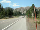
- U. S. Highway 395:
at Conway Summit, north edge of Mono Basin;
near Conway Summit;
near Deadman Summit;
Literature Referring To This Location:
-
Billeb, Emil B. 1968.
Mining Camp Days.
Berkeley, CA: Howell-North Books, 1968.
{TAS}
-
Browne, J. Ross. 1863.
A Trip to Bodie Bluff and the Dead Sea of the West -- in 1863.
Harper's New Monthly Magazine.
Olympic Valley, California: Outbooks, 1978.
{TAS}
-
Bursik, M. 1989.
Late Quaternary volcano-tectonic evolution of the Mono Basin, eastern California.
California Institute of Technology, Ph.D, dissertation.
-
Bursik, M., C. Renshaw, J. McCalpin, and M. Berry. 2002.
A Volcanotectonic Cascade: Activation of Range Front Faulting and Eruptions by Dike Intrusion, Mono Basin-Long Valley Caldera, CA, USA.
Journal of Geophysical Research.
108(B8):1-8.
{TAS}
-
Bursik, Marcus and Kerry Sieh. 1989.
Range Front Faulting and Volcanism in the Mono Basin, Eastern California.
Journal of Geophysical Research.
94(111):15,587-15,609.
{TAS-pdf}
-
Cain, Ella M. 1961.
The Story of Early Mono County.
San Francisco, California: Fearon Publishers, 1961.
{TAS}
-
California Partners In Flight. 2005.
The sagebrush bird conservation plan: a strategy for protecting and managing sagebrush habitats and associated birds in California.
Stinson Beach, CA: PRBO Conservation Science, 2005.
http://www.prbo.org/calpif/pdfs/sage.v-1.pdf
{TAS-pdf}
Retrieved 12 January 2021.
-
State of California, State Water Resources Control Board. 1998.
Order 98-05.
In the Matter of Stream and Waterfowl Habitat Restoration Plans and Grant Lake Operations and Management Plan Submitted by the Los Angeles Department of Water and Power.
{TAS-pdf}
Date retrieved: http://www.waterboards.ca.gov/waterrights/board_decisions/adopted_orders/orders/1998/wro98-05.pdf
-
Fletcher. 1982.
The Mono Basin in the nineteenth century : discovery, settlement, land use.
M. A. Thesis, University of California at Berkeley.
Earth Science Library. Possibly forms the basis of "Paiute, Prospector, Pioneer."
-
Fletcher, Thomas C. 1987.
Paiute, Prospector, Pioneer: A History of the Bodie-Mono Lake Area in the Ninteenth Century.
Lee Vining, CA: Artemisia Press, 1987.
{TAS}
-
Gilbert, C. M., M. N. Christensen, Yehya Al-Rawi, and K. R. Lajoie. 1968.
Structural and Volcanic History of Mono Basin, California-Nevada.
pp. 275-329 in Coats, Robert R., Richard L. Hay, and Charles A. Anderson.
Studies in Volcanology: A Memoir in Honor of Howel Williams.
Memoir 116.
Boulder, Colorado: Geological Society of America, 1968.
{TAS}
-
Hickman, James C. (Ed.). 1993.
The Jepson manual: higher plants of California.
Berkeley, CA: University of California Press..
-
Higgins, C. T., T Flynn, R. H. Chapman, D. T. Trexler, G. R. Chase, C. F. Bacon, and G. Ghusn, Jr. 1985.
Geothermal systems of the Mono Basin - Long Valley region, eastern California and western Nevada.
DOE/SF/12230-T1.
{TAS-pdf}
-
Jayko, A.S., P. E. Hart, J. R. Childs, M. H. Cormier, D. A. Ponce, N. A. Athens, and J. S. McClain. 2013.
Methods and spatial extent of geophysical Investigations, Mono Lake, California, 2009 to 2011.
U.S. Geological Survey Open-File Report 2013–1113.
http://pubs.usgs.gov/of/2013/1113/
-
Jehl, Joseph R. 1983.
Tufa Formation at Mono Lake.
California Geology.
36(1):3.
{TAS}
Gives anecdotal evidence for rate of growth of tufa towers.
-
Johnson, Stephen. 1983.
At Mono Lake.
San Francisco, California: Friends of the Earth Foundation, 1983.
{TAS}
Catalog assembled for a traveling exhibition of photographs of Mono Lake.
-
Likes, Robert C. 197x.
Mono Mills to Bodie.
Desert Magazine.
{TAS}
Available on the Internet, by permission, at: http://www.explorehistoricalif.com/mono_mills.html.
-
McNutt, Steve, William Bryant, and Rick Wilson. 1991.
Mono Lake Earthquake of October 23, 1990.
California Geology.
44(2):27-32.
{TAS}
-
Mono County. 2007.
Mono County Watershed Assessment.
{TAS-pdf}
Date retrieved: 4 February 2016, http://inyo-monowater.org/wp-content/uploads/2011/09/Assessments_MonoBasin.pdf
-
National Research Council (U.S.). 1897.
Mono Basin Ecosystem: Effects of Changing Lake Levels.
Washington, DC: National Academy Press, 1987.
{TAS}
-
Oldow, John S. 2003.
Active transitional bouldary zone between the western Great Basin and the Sierra Nevada block, western U. S. Cordillera.
Geology.
31(12):1033-1036.
{TAS-pdf}
-
Pavlik, Bruce Michael. 1985.
Sand dune flora of the Great Basin and Mojave deserts of California, Nevada, and Oregon.
Madrońo.
32(4):197-213.
{TAS}
-
Reheis, Marith C., Scott Stine, and Andrei M. Sarna-Wojcicki. 2002.
Drainage reversals in Mono Basin during the late Pliocene and Pleistocene.
GSA Bulletin.
114(8):991-1006.
{TAS-pdf}
-
Russell, Israel C. 1889.
Quaternary history of Mono Valley, California.
Eighth Annual Report of the U. S. Geological Survey.
Washington, DC: United States Geological Survery, 1889.
{TAS}
-
Shaffer, Wil, Marcus Bursik, and Carl Renshaw. 2010.
Elastic source model of the North Mono eruption (1325–1368 A.D.) based on shoreline deformation.
Bulletin of Volcanology.
72(10):1141-1152.
-
Sieh, K., and M. Bursik. 1986.
Most recent eruption of the Mono Craters, eastern central California.
Journal of Geophysical Research.
91: 12539-12571.
-
Stewart, J. H., John E. Carlson, and Dann C. Johannesen. 1982.
Geologic Map of the Walker Lake 1° By 2° Quadrangle, California and Nevada.
Miscellaneous Field Investigations Map MF-1382-A.
Washington, DC: United States Geological Survey, 1982.
{TAS-map}
-
Stine, S. 1990.
Late Holocene fluctuations of Mono Lake, eastern California.
Paleogeography, Paleoclimatology, Paleoecology.
78: 333-381.
-
Taylor, Dean Wm. 1981.
Plant checklist for the Mono Basin, California.
Mono
Basin Research Group Contribution 3..
Lee Vining, CA: Mono Lake Committee, 1981.
-
Toft, Catherine, and Deborah Elliott-Fisk. 2002.
Patterns of vegetation along a spatiotemporal gradient on shoreline strands of a desert basin lake.
Plant Ecology.
158(1):21-39.
{TAS-pdf}
-
Unruh, Jeffrey, James Humphrey and Andrew Barron. 2003.
Transtensional model for the Sierra Nevada frontal fault system, eastern California.
Geology.
31(4):327-330.
{TAS-pdf}
-
Wesnousky, Steven G. 2005.
The San Andreas and Walker Lane fault systems, western North America: transpression, transtension, cumulative slip and the structural evolution of a major transform plate boundary.
Journal of Structural Geology.
27: 1505-1512.
{TAS-pdf}
-
Winkler, David W. 1977.
An Ecological Study of Mono Lake, California.
Institute of Ecology Publication No. 12.
Davis, California: University of California, June 1977.
{TAS}
-
Wood, S. H. 1983.
Chronology of late Pleistocene and Holocene volcanics, Long Valley and Mono Basin geothermal areas, eastern California.
U. S. Geological Survey Open-File Report 83-747.
-
Young, James A, and Charlie D. Clements. 2002.
Purshia: the wild and bitter roses.
Reno, Nevada: University of Nevada Press, 2002.
{TAS}
-
Young, James A., Charlie D. Clements, and Henricus C. Jansen. 2007.
Sagebrush Steppe.
pp. in Barbour, Michael G., Todd Keeler-Wolf, and Allan A. Schoenherr.
Terrestrial Vegetation of California.
Third Edition.
Berkeley, CA: University of California Press, 2007.
{TAS}
Area Plant Lists that contain this location:
Species collected at or near this location.
This list summarizes plants collected or observed at this specific, named location.
It does not include plants collected or observed at nearby named or unnamed locations.
It may be more instructive to use the Area Lists that contain this location.
- TAS – The plant was collected by Tom Schweich.
- Oth – The plant was collected by someone, but not Tom.
- Obs – The plant was observed, but not collected.
Cupressaceae
Juniperus grandis R. P. Adams. Sierra Juniper, Western Juniper (Oth)
Juniperus occidentalis Hook. Western Juniper (Obs)
Juniperus osteosperma (Torrey) Little. Utah Juniper (Oth)
Ephedraceae
Ephedra viridis Cov. Green Ephedra (Obs)
Pinaceae
Pinus contorta Loudon murrayana (Grev. & Balf.) Critchf. Sierra Lodgepole Pine (Obs)
Pinus jeffreyi Grev. & Balf. Jeffrey Pine (Obs)
Pinus monophylla Torrey & Fremont. Single Leaf Pinyon Pine (Obs)
Pinus ponderosa Laws. Ponderosa Pine (Oth)
Amaranthaceae
Nitrophila occidentalis (Moq.) S. Watson. boraxweed (Obs)
Apiaceae
Berula erecta (Huds.) Coville. Cut-Leaf Water Parsnip (Obs)
Cicuta douglasii (DC.) J. M. Coult. & Rose. Western Water Hemlock (Obs)
Cymopterus cinerarius A. Gray. Gray Springparsley (TAS)
Lomatium nevadense (S. Watson) J. M. Coult. & Rose nevadense. (Obs)
Sphenosciadium capitellatum A. Gray. (Obs)
Asteraceae
Achillea millefolium L. Common Yarrow (Obs)
Artemisia arbuscula Nutt. Little Sagebrush (Oth)
Artemisia ludoviciana Nutt. Silver Wormwood (Obs)
Artemisia tridentata Nutt. Big Sagebrush (Obs)
Chaenactis douglasii (Hook.) Hook. & Arn. douglasii. Douglas' Dustymaiden (TAS+Obs)
Chrysothamnus viscidiflorus (Hook.) Nutt. viscidiflorus. Yellow Rabbitbrush (Obs)
Cirsium vulgare (Savi) Ten. Bull Thistle (Obs)
Dieteria canescens (Pursh) Nutt. Hoary Tansyaster (Obs)
Ericameria nana Nutt. dwarf goldenbush (Obs)
Ericameria nauseosa (Pall. ex Pursh) G. I. Nesom & G. I. Baird. Rubber Rabbitbush (Obs)
Ericameria nauseosa (Pall. ex Pursh) G. I. Nesom & G. I. Baird hololeuca (A.Gray) G.L.Nesom & G.I.Baird. Rubber Rabbitbush (Oth)
Ericameria nauseosa (Pall. ex Pursh) G. I. Nesom & G. I. Baird oreophila (A.Nelson) G.L.Nesom & G.I.Baird. Rubber Rabbitbush (Obs)
Ericameria nauseosa (Pall. ex Pursh) G. I. Nesom & G. I. Baird speciosa (Nutt.) G.L.Nesom & G.I.Baird. Rubber Rabbitbush (Obs)
Ericameria parryi (A. Gray) G. I. Nesom & G. I. Baird (A. Nelson & P. B. Kenn.) G. I. Nesom & G. I. Baird monocephala (A. Nelson & P. B. Kenn.) G. I. Nesom & G. I. Baird. One-Headed Rabbitbrush (Obs)
Ericameria parryi (A. Gray) G. I. Nesom & G. I. Baird vulcanica (Greene) G. I. Nesom & G. I. Baird. Vulcan Rabbitbrush (Obs)
Eatonella nivea (D.C.Eaton) A. Gray. White False Tickhead (TAS)
Eriophyllum lanatum (Pursh) J. Forbes integrifolium (Hook.) Smiley. Oregon Sunshine (Oth)
Gnaphalium palustre Nutt. Western Marsh Cudweed (Oth)
Hieracium horridum Fr. Prickly Hawkweed (Oth)
Ionactis alpina (Nutt.) Greene. Lava Ankle-Aster (Obs)
Pleiacanthus spinosus (Nutt.) Rydb. Thorny Skeletonweed (Obs)
Psathyrotes annua (Nutt.) A. Gray. Annual Psathyrotes (Obs)
Pseudognaphalium thermale (E. E. Nelson) G. L. Nesom. (Obs)
Pyrrocoma lanceolata (Hook.) Greene. Intermountain Pyrrocoma (Obs)
Senecio hydrophilus Nutt. Alkali-Marsh Butterweed (Obs)
Senecio spartioides Torr. & A. Gray. Broomlike Ragwort (Oth)
Solidago elongata Nutt. (Obs)
Solidago spectabilis (D. C. Eaton) A. Gray. Basin Goldenrod (Obs)
Symphyotrichum frondosum (Nutt.) G. L. Nesom. Short-Rayed Alkali Aster (Obs)
Symphyotrichum lanceolatum (Willd.) G. L. Nesom hesperium (A. Gray) G. L. Nesom. Western Lance-Leaved Aster (Obs)
Taraxacum officinale F. H. Wigg. Common Dandelion (Obs)
Tetradymia axillaris A. Nelson longispina (M. E. Jones) Strother. Long-Spined Horse Brush (Obs)
Tetradymia canescens DC. Spineless Horsebush (Obs)
Tetradymia glabrata Torrey & A. Gray. Littleleaf Horsebrush (Obs)
Tetradymia tetrameres (S. F. Blake) Strother. Four-part Horsebush (Oth)
Betulaceae
Betula occidentalis Hook. Water Birch (Obs)
Boraginaceae
Cryptantha ambigua (A. Gray) Greene. Basin Cryptantha (Oth)
Cryptantha circumscissa (Hook. & Arn.) I. M. Johnst. Cushion Cryptantha (Obs)
Cryptantha circumscissa (Hook. & Arn.) I. M. Johnst. circumscissa. Cushion Cryptantha (TAS)
Cryptantha confertiflora (Greene) Payson. Basin Yellow Cryptantha (Obs)
Cryptantha echinella Greene. Prickly Cryptantha (Obs)
Cryptantha flavoculata (A. Nelson) Payson. Roughseed Cryptantha (Obs)
Cryptantha glomeriflora Greene. Truckee Cryptantha (Obs)
Cryptantha micrantha (Torr.) I. M. Johnst. micrantha. Redroot Cryptantha (TAS)
Cryptantha watsonii (A. Gray) Greene. Watson's Cryptantha (TAS)
Hackelia micrantha (Eastw.) J. L. Gentry. Jessica Sticktight (Obs)
Heliotropium curassavicum L. Seaside Heliotrope (Obs)
Lappula redowskii (Hornem.) Greene redowskii. Stickseed (Obs)
Nama densum Lemmon. Leafy Nama (Oth)
Phacelia bicolor Torr. ex S. Watson bicolor. Two-Color Phacelia (Obs)
Plagiobothrys kingii (S. Watson) A. Gray. Great Basin Popcornflower (Obs)
Tiquilia nuttallii (Hook.) A. T. Richardson. Nuttall's Crinklemat (Obs)
Brassicaceae
Boechera cobrensis (M. E. Jones) Dorn. Sagebrush Rockcress (Oth)
Cusickiella quadricostata (Rollins) Rollins. Bodie Hills Draba (Obs)
Descurainia pinnata (Walter) Britton. Western Tansymustard (Obs)
Descurainia sophia (L.) Webb. Tansy Mustard (Obs)
Lepidium chalepense L. (Obs)
Lepidium lasiocarpum Nutt. Shaggyfruit Pepperweed (Obs)
Nasturtium officinale W. T. Aiton. Watercress (Obs)
Physaria kingii (S. Watson) O'Kane & Al-Shehbaz. King Bladderpod (Obs)
Thelypodium laciniatum (Hook.) Endl. ex Walp. Cutleaf Thelypody (Oth)
Thelypodium milleflorum A. Nelson. Many-Flower Thelypody (Oth)
Cactaceae
Opuntia polyacantha Haw. erinacea (Engelm. & Bigelow) Parfitt. Grizzly Bear Pricklypear (Obs)
Caprifoliaceae
Symphoricarpos r. A. Gray rotundifolius. Roundleaf Snowberry (Obs)
Caryophyllaceae
Arenaria paludicola Rob. marsh sandwort (Obs)
Gypsophila paniculata L. Baby's Breath (Obs)
Minuartia nuttallii (Pax) Briq. fragilis (Maguire & A.H. Holmgren) Rabeler & R.L. Hartm. (Obs)
Saponaria officinalis L. Bouncingbet (Obs)
Stellaria longipes Goldie longipes. Longstalk Starwort (Obs)
Chenopodiaceae
Atriplex argentea Nutt. Silverscale Saltbush (Obs)
Bassia hyssopifolia (Pall.) Kuntze. Bassia (Obs)
Chenopodium atrovirens Rydb. Pinyon Goosefoot (Obs)
Chenopodium fremontii S. Watson. Fremont's Goosefoot (Obs)
Chenopodium leptophyllum (Moq.) Nutt. ex S. Watson. Narrowleaf Goosefoot (Obs)
Dysphania botrys (L.) Mosyakin & Clemants. Jerusalem Oak Goosefoot (Obs)
Grayia spinosa (Hook.) Moq. Spiny Hop Sage (Obs)
Salsola tragus L. Tumbleweed (Obs)
Stutzia covillei (Standl.) E. H. Zacharias. (Obs)
Suaeda calceoliformis (Hook.) Moquin. Pursh Seepweed (Obs)
Cleomaceae
Cleomella parviflora A. Gray. Slender Cleomella (Oth)
Convolvulaceae
Cressa truxillensis Kunth. spreading alkaliweed (Obs)
Cornaceae
Cornus sericea L. sericea. Creek Dogwood (Obs)
Elaeagnaceae
Shepherdia argentea Nutt. Buffalo Berry (Obs)
Fabaceae
Astragalus casei A. Gray. Case's Milkvetch (Oth)
Astragalus gibbsii Kellogg. Gibb's Milkvetch (Oth)
Astragalus lentiginosus Hook. fremontii (A. Gray) S. Watson. Fremont's Milkvetch (Oth)
Astragalus lentiginosus Hook. ineptus (A. Gray) M. E. Jones. Freckled Milkvetch (Oth)
Astragalus monoensis Barneby. Mono Milk-Vetch (Obs)
Astragalus pseudiodanthus Tonopah Milk-Vetch. Barneby (Obs)
Lupinus L. Lupine (Obs)
Lupinus argenteus Pursh montigenus (A. Heller) Barneby. Kellogg's Spurred Lupine (Obs)
Lupinus duranii Eastw. Mono Lake Lupine (Obs)
Ladeania lanceolata (Pursh) A. N. Egan & Reveal. Dune Scurfpea (Oth)
Medicago lupulina L. Black Medick (Obs)
Melilotus albus Medik. White Sweet Clover (Obs)
Psorothamnus polydenius (S. Watson) Rydb. Nevada Dalea (Oth)
Trifolium andersonii A. Gray beatleyae (J. M. Gillett) Isely. (Oth)
Trifolium wormskioldii Lehm. Cows Clover (Oth)
Geraniaceae
Erodium cicutarium (L.) L'Her. ex Aiton. Hemlock-leav'd Crane's-bill (Obs)
Loasaceae
Mentzelia albicaulis (Douglas ex Hook.) Douglas ex Torr. & A. Gray. White-Stem Blazing Star (Obs)
Mentzelia dispersa S. Watson. Bushy Blazing Star (Oth)
Mentzelia laevicaulis (Hook.) Torr. & A. Gray. Smoothstem Blazing Star (Obs)
Mentzelia torreyi A. Gray. Torrey's Blazing Star (Obs)
Malvaceae
Sidalcea oregana (Torr. & A. Gray) A. Gray spicata (Regel) C. L. Hitchc. Oregon Checkerbloom (Oth)
Onagraceae
Camissonia parvula (Torr. & A. Gray) P. H. Raven. Lewis River Suncup (TAS)
Chamerion angustifolium (L.) Holub. Fireweed (Obs)
Chamerion angustifolium (L.) Holub circumvagum (Mosquin) Hoch. Fireweed (Obs)
Chylismia claviformis (Torr. & Frém.) A. A. Heller integrior (P. H. Raven) W.L. Wagner & Hoch. Browneyes (Oth)
Epilobium ciliatum Raf. ciliatum. Fringed Willowherb (Obs)
Eremothera boothii (Douglas) W.L. Wagner & Hoch. Booth's Evening Primrose (Obs)
Eremothera boothii (Douglas) W.L. Wagner & Hoch alyssoides (Hook. & Arn.) W.L. Wagner & Hoch. Pine Creek Evening Primrose (Obs)
Gayophytum ramosissimum Torr. & A. Gray. Pinyon Groundsmoke (Obs)
Oenothera cespitosa Nutt. marginata (Hook. & Arn.) Munz. Tufted Evening Primrose (TAS)
Oenothera deltoides Torr. & Frémont cognata (Jeps.) W. M. Klein. Birdcage Evening-Primrose (Oth)
Orobanchaceae
Castilleja chromosa A. Nelson. Desert Indian Paintbrush (Oth)
Castilleja linariifolia Benth. Wyoming Indian Paintbrush (Oth)
Castilleja miniata Hook. miniata. Giant Red Indian Paintbrush (Oth)
Castilleja minor (A. Gray) A. Gray minor. Lesser Indian Paintbrush (Obs)
Papaveraceae
Argemone munita Durand & Hilg. Flatbud Prickly Poppy (Obs)
Parnassiaceae
Parnassia palustris L. California Grass of Parnassus (Oth)
Phrymaceae
Diplacus mephiticus (Greene) G.L. Nesom. Skunky Monkey Flower (Obs)
Erythranthe guttata (Fisch. ex DC.) G.L. Nesom. Seep Monkeyflower (Obs)
Erythranthe suksdorfii (A. Gray) N.S. Fraga. Suksdorf's monkeyflower (Oth)
Erythranthe utahensis (Pennell) Nesom. Utah Monkeyflower (Obs)
Plantaginaceae
Callitriche palustris L. Vernal Star Wort (Oth)
Collinsia parviflora Lindl. Maiden Blue-eyed Mary (Oth)
Veronica americana (Raf.) Benth. American Speedwell (Oth)
Polemoniaceae
Aliciella leptomeria (A. Gray) J.M. Porter. Sand Gilia (Obs)
Leptosiphon pachyphyllus (R. Patt.) J. M. Porter & L. A. Johnson. Sierra Linanthus (Obs)
Linanthus pungens (Torr.) J. M. Porter & L. A. Johnson. Granite Prickly Phlox (Obs)
Polygonaceae
Chorizanthe brevicornu Torr. spathulata (Rydb.) C. L. Hitchc. Great Basin Brittle Spineflower (Oth)
Eriogonum. Buckwheat (Obs)
Eriogonum ampullaceum J. T. Howell. Mono Buckwheat (Obs)
Eriogonum baileyi S. Watson baileyi. Bailey's Buckwheat (Oth)
Eriogonum brachyanthum Coville. Shortflower Buckwheat (Oth)
Eriogonum cernuum Nutt. Nodding Buckwheat (Obs)
Eriogonum lobbii Torr. & A. Gray. Lobb's Buckwheat (Obs)
Eriogonum microthecum Nutt. (Obs)
Eriogonum nudum Douglas ex Benth. deductum (Greene) Jeps. Naked Buckwheat (Oth)
Eriogonum nummulare M. E. Jones. Money Buckwheat (Obs)
Eriogonum rosense A. Nelson & P. B. Kenn. rosense. Rosy Buckwheat (Obs)
Eriogonum spergulinum A. Gray. Spurry Buckwheat (Oth)
Eriogonum spergulinum A. Gray reddingianum (M. E. Jones) J. T. Howell. Redding Buckwheat (Oth)
Eriogonum umbellatum Torr. nevadense Gand. Sulphur-Flower Buckwheat (Oth)
Eriogonum vimineum Douglas ex Benth. Willow Buckwheat (Obs)
Eriogonum wrightii Torr. ex Benth. subscaposum S. Watson. Bastardsage (Oth)
Fallopia convolvulus (L.) A.Löve. Black Bindweed (Obs)
Oxytheca dendroidea Nutt. (Obs)
Oxytheca dendroidea Nutt. dendroidea. (Oth)
Persicaria amphibia (L.) Delarbre. Water Smartweed (Oth)
Polygonum aviculare L. depressum (Meisn.) Arcangeli. Prostrate Knotweed (Obs)
Rumex acetosella L. Sheep Sorrel (Obs)
Rumex crispus L. Curley Dock (Obs)
Rumex fueginus Phil. Golden Dock (Obs)
Rumex triangulivalvis (Danser) Rech. f. Triangular-Valved Dock (Obs)
Ranunculaceae
Delphinium andersonii A. Gray. Anderson's Larkspur (Oth)
Ranunculus cymbalaria Pursh. Alkali Buttercup (Obs)
Rosaceae
Amelanchier utahensis Koehne. Utah Service-Berry (Oth)
Cercocarpus ledifolius Nutt. Curl-leaf Mountain Mahogany (Obs)
Prunus andersonii A. Gray. Desert Peach (Obs)
Prunus emarginata (Douglas) Eaton. Bitter Cherry (Obs)
Purshia tridentata (Pursh) DC. tridentata. Antelope Bitterbrush (Obs)
Rosa woodsii Lindl. ultramontana (S. Watson) Roy L. Taylor & MacBryde. Mountain Rose (Obs)
Rubiaceae
Galium multiflorum Kellogg. Many-Flower Bedstraw (Obs)
Salicaceae
Populus deltoides Marshall. Eastern Cottonwood (Obs)
Populus fremontii S. Watson. Fremont Cottonwood (Obs)
Populus nigra L. italica Du Roi. Lombardy Poplar (Obs)
Populus tremuloides Michx. Quaking Aspen (Obs)
Populus trichocarpa Torr. & A.Gray ex Hook. Black Cottonwood (Obs)
Salix exigua Nutt. exigua. Coyote Willow, Narrow-Leaved Willow (Obs)
Salix exigua Benth. hindsiana (Benth.) Dorn. Sandbar Willow (Obs)
Salix geyeriana Andersson. Geyer Willow (Obs)
Salix laevigata Bebb. Red Willow (Obs)
Salix lasiandra Benth. Pacific Willow (Obs)
Salix lasiolepis Benth. Arroyo Willow (Obs)
Salix lutea Nutt. Yellow Willow (Obs)
Santalaceae
Arceuthobium americanum Nutt. ex Engelm. American Dwarf Mistletoe (Oth)
Sarcobataceae
Sarcobatus vermiculatus (Hook.) Torr. Greasewood (Obs)
Scrophulariaceae
Verbascum thapsus L. Common Mullein (Obs)
Tamaricaceae
Tamarix ramosissima Ledeb. Salt Cedar (Obs)
Urticaceae
Urtica dioica L. holosericea (Nutt.) Thorne. Stinging Nettle (Obs)
Cyperaceae
Amphiscirpus nevadensis (S. Watson) Oteng-Yeb. Nevada Bulrush (Obs)
Bolboschoenus maritimus (L.) Palla. (Obs)
Carex diandra Schrank. Lesser-Panicled Sedge (Obs)
Carex douglasii Boott. Douglas Sedge (Obs)
Carex lasiocarpa Ehrh. Woolly Sedge (Obs)
Carex nebrascensis Dewey. Nebraska Sedge (Obs)
Carex pellita Muhl. ex Willd. Wooly Sedge (Oth)
Carex praegracilis W. Boott. Clustered Field-Sedge (Obs)
Carex senta Boott. Swamp Carex (Oth)
Carex subfusca W. Boott. Brown Sedge (Obs)
Carex utriculata Boott. Beaked Sedge (Obs)
Cyperus squarrosus L. Bearded Flatsedge (Oth)
Eleocharis bella (Piper) Svenson. Beautiful Spikerush (Obs)
Eleocharis macrostachya Britton. Common Spike-Rush (Obs)
Eleocharis parishii Britton. Parish's Spike-Rush (Obs)
Eleocharis rostellata (Torr.) Torr. Beaked Spikerush (Obs)
Schoenoplectus acutus (Muhl. ex Bigelow) Á. Löve & D. Löve occidentalis (S. Watson). Hardstem Bulrush (Obs)
Schoenoplectus americanus (Pers.) Volkart ex Schinz & R. Keller. Chairmaker's Bulrush (Obs)
Schoenoplectus pungens (Vahl) Palla. Threesquare (Obs)
Iridaceae
Iris missouriensis Nutt. Western Blue Flag (Obs)
Sisyrinchium halophilum Greene. Nevada Blue-Eyed Grass (Obs)
Juncaceae
Juncus balticus Willd. Baltic Rush (Obs)
Juncus cooperi Engelm. Cooper's Rush (Obs)
Juncus effusus L. common rush (Obs)
Juncus macrandrus Coville. Long-Anther Rush (Obs)
Juncus nevadensis S. Watson nevadensis. Nevada Rush (Obs)
Juncaginaceae
Triglochin concinna Burtt Davy debilis (M. E. Jones) J. T. Howell. Marsh Arrowgrass (Obs)
Triglochin maritima L. Seaside Arrowgrass (Obs)
Liliaceae
Calochortus bruneaunis A. Nelson & J. F. Macbr. Bruneau Mariposa Lily (Oth)
Melanthiaceae
Veratrum californicum Durand californicum. Helleborine, Corn Lily (Obs)
Zigadenus venenosus S. Watson venenosus. Meadow Death Camas (Oth)
Orchidaceae
Epipactis gigantea Hook. Stream Orchid (Obs)
Platanthera dilatata (Pursh) Lindl. ex Beck leucostachys (Lindl.) Luer. Sierra Bog Orchid (Oth)
Platanthera sparsiflora (S. Watson) Schltr. Sparse-Flowered Bog Orchid (Obs)
Poaceae
Agrostis gigantea Roth. Redtop (Obs)
Bromus tectorum L. Cheat Grass (Obs)
Distichlis spicata (L.) E. Greene. Saltgrass (Obs)
Deschampsia cespitosa (L.) P. Beauv. cespitosa. (Obs)
Elymus cinereus Scribn. & Merr. Great Basin Wild Rye (Obs)
Elymus elymoides (Raf.) Swezey. Squirreltail Grass (Obs)
Elymus elymoides (Raf.) Swezey elymoides. Squirreltail Grass (Oth)
Elymus multisetus (J. G. Sm.) Burtt Davy. Big Squirreltail (Obs)
Elymus triticoides Buckley. Beardless Wildrye (Obs)
Holcus mollis L. creeping velvetgrass (Obs)
Hordeum jubatum L. jubatum. Foxtail Barley (Obs)
Muhlenbergia andina (Nutt.) Hitchc. Foxtail Muhly (Oth)
Muhlenbergia asperifolia (Nees & Meyen ex Trin.) Parodi. Alkali Muhley (Obs)
Muhlenbergia filiformis (Thurb. ex S. Watson) Rydb. Pullup Muhly (Obs)
Muhlenbergia minutissima (Steud.) Swallen. Annual Muhly (Oth)
Phleum pratense L. Timothy (Oth)
Poa pratensis L. pratensis. Kentucky Bluegrass (Obs)
Poa secunda J. Presl. Sandberg Bluegrass. (Obs)
Poa secunda J. Presl secunda. Sandberg Bluegrass. (Obs)
Polypogon interruptus Kunth. ditch rabbitsfoot grass (Obs)
Polypogon monspeliensis (L.) Desf. Rabbit's-Foot Grass (Obs)
Puccinellia lemmonii (Vasey) Scribn. Lemmon's alkaligrass (Obs)
Puccinellia nuttalliana (Schult.) Hitchc. Nuttall's Alkali Grass (Obs)
Stipa L. (Oth)
Stipa comata Trin. & Rupr. Needle and Thread (Obs)
Stipa hymenoides Roem. & Schult. Indian Rice Grass (Obs)
Stipa occidentalis Thurb. ex S. Watson. Western Needlegrass (Oth)
Stipa occidentalis Thurb. ex S. Watson pubescens (Vasey) J. R. Maze et al. Common Western Needlegrass (Oth)
Stipa speciosa Trin. & Rupr. Desert Needle Grass (Oth)
Stipa thurberiana Piper. (Oth)
Trisetum cernuum Trin. Tall Trisetum (Obs)
Potamogetonaceae
Stuckenia pectinata (L.) Börner. (Oth)
Ruscaceae
Maianthemum stellatum (L.) Link. Starry False Lily of the Valley (Obs)
Typhaceae
Typha latifolia L. Cattail (Obs)
 Eastern Mojave Vegetation