
Eastern Mojave Vegetation
By Tom Schweich
|
Eastern Mojave Vegetation | Images -- Geography - Lake County, CO |
|
By Tom Schweich |
|

Unclassified Geography - Idaho Geography - Park County, CO Geography - Summit County, CO Geography - Arizona Geography - British Columbia Geography - California Geography - California's Colorado Desert Alaska Geography - Mono Lake Basin, California Geography - Mono County, California Geography - San Luis Obispo County, California Geography - Marin County, California Geography - Santa Clara County Alameda Garden Geography - Central Mojave Geography - New Mexico Geography - Eastern Mojave Geography - Northern Mojave Geography - Colorado Geography - Alamosa County, CO Geography - Boulder County, CO Geography - Clear Creek County, CO Geography - Chaffee County, CO Geography - Douglas County, CO Geography - Gilpin County, CO Geography - Golden, Colorado Geography - Weld County, CO Geography - Hinsdale County, CO Geography - Jefferson County, CO Geography - North Table Mountain, Jefferson Cty, CO Geography - Lake County, CO Geography - Larimer County, CO Geography - Nevada Geography - Oregon Geography - Utah Geography - Virginia Geography - Washington Geography - Wyoming Spain - Andalucia Spain - Castilla y Leon Spain - Castilla-La Mancha Spain - Extremadura Spain - Galicia Spain - Madrid Portugal Geology Economic Geology Climatology Botany Salvia dorrii Frasera albomarginata Species Species - Polygonaceae Species - Brassicaceae Species - Brassicaceae, Physaria vitulifera Species - Rosaceae Species - Fabaceae Species - Onagraceae Species - Polemoniaceae Species - Boraginaceae Species - Plantaginaceae Species - Asteraceae Species - Poaceae Zoology Ecology Archeology Customer Satisfaction General Arizona California Kansas Missouri Nebraska New York Christmas 2002 Family Photos Family Documents Family Photos 2003 Art of Lydia Schweich Portraits Railroad Geography - Germany |
Images are organized by the topics listed at left. Click on a topic name to see images with that topic. Would you like to use these photographs in your school term paper or report? License is hereby granted for non-commercial use of the images contained herein provided that the images are reproduced with the copyright notice intact. This means that we give you our permission to use the photographs and information you find here in your school term papers and reports. You may resize the photograph to fit your needs, but you may not remove the copyright. Your term paper should note that the photographs are reproduced with permission and it should have a reference to this web site, such as: "Photograph �1999 Tom Schweich. Used by permission, http://www.schweich.com" If you have a comment or a question about a photograph you may write to me at tas4@schweich.com I will answer you as soon as I can. I sometimes post interesting questions in my FAQ, but I will not disclose your full name or address.
| Brumley
| 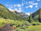
Brumley � still a beautiful place. | Photographed 20 Jul 2022.
Location records that use this photograph:
Article records that use this photograph:
images/20220720_091852sm.jpg
| 
Collecting locality just a half mile north of Brumley. | Photographed 20 Jul 2022.
Article records that use this photograph:
images/20220720_112921sm.jpg
| 
Coll. No. 2721, Chamerion angustifolium at Brumley. | Photographed 18 August 2021.
Location records that use this photograph:
Article records that use this photograph:
images/20210818_114839sm.jpg
| 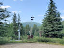
Sno-Tel station at Brumley. | Photographed 18 August 2021.
Location records that use this photograph:
Article records that use this photograph:
images/20210818_094538sm.jpg
| Forest Road 189
| 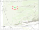
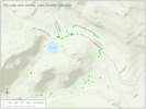
Location of Plant Collections on Forest Road 189. | Map prepared 24 July 2023.
Location records that use this photograph:
Article records that use this photograph:
images/No_Name_Gulch_FR189_20230724_sm.jpg
| 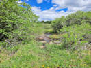
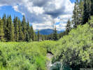
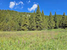
Little creek in the willow thicket. | Photographed 20 July 2023.
Location records that use this photograph:
Article records that use this photograph:
images/20230719_113114sm.jpg
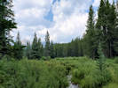
| 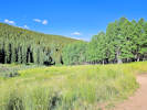
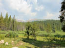
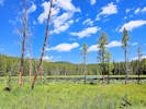
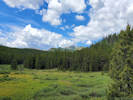
Uppermost meadow on Forest Road 189. | Photographed 19 July 2023.
Location records that use this photograph:
Article records that use this photograph:
images/20230719_084820sm.jpg
| 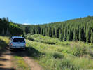
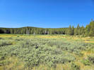
Uppermost meadow on Forest Road 189. | Photographed 19 July 2023.
Location records that use this photograph:
Article records that use this photograph:
images/20230719_084814sm.jpg
| Leadville
| 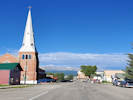
Leadville in the morning. | Photographed 20 Jul 2022 from in front of 209 7th Street.
Location records that use this photograph:
Article records that use this photograph:
images/20220720_080809sm.jpg
| Lily Lake
| 
View of Lily Lake. | Photographed 13 July 2021.
Location records that use this photograph:
Article records that use this photograph:
images/20210713_094803sm.jpg
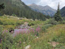
| 
View opposite of Lily Lake | Photographed 13 July 2021. Collections No. 2580 through 2585 were made in the foreground of this photograph.
Location records that use this photograph:
Article records that use this photograph:
images/20210713_094533sm.jpg
| 
Panorama of Lily Lake. | Photographed 17 August 2021.
Location records that use this photograph:
Article records that use this photograph:
images/20210817_095749sm.jpg
| 
Lily Lake and vicinity. | Map prepared 24 July 2023.
Location records that use this photograph:
Article records that use this photograph:
images/COLakLilyLake_Mapsm.jpg
| 
Lily Lake from the other side. | Photographed 18 July 2023. This is approximately the location of Coll. No. 3113, Lily Lake.
Location records that use this photograph:
Article records that use this photograph:
images/20230718_114958sm.jpg
| Meadow3099 -- Unnamed meadow along Forest Road 109
| 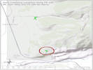
Location of Plant Collections at an unnamed meadow on Forest Road 109. | Map prepared 24 July 2023.
Location records that use this photograph:
Article records that use this photograph:
images/No_Name_Gulch_FR109_20230724_sm.jpg
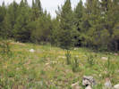
| Meadow3099 -- Unnamed meadow along Forest Road 109.
| 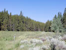
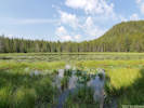
Collecting locality of Coll. Nos. 2598-2608. | Photographed 15 July 2021.
Location records that use this photograph:
Article records that use this photograph:
images/20210715_094544sm.jpg
| North Fork West Tennessee Creek
| 
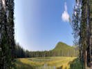
North Fork of West Tennessee Creek, near Lily Lake. | Photographed 17 August 2021.
Location records that use this photograph:
Article records that use this photograph:
images/20210817_122403sm.jpg
| 
Collecting locality for Coll. Nos. 2588-2594. | Photographed 13 July 2021.
Article records that use this photograph:
images/20210713_121233sm.jpg
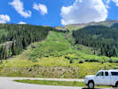
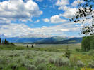
| Tennessee Park
| 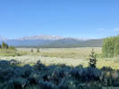
View across Tennessee Park to Mount Massive. | Photographed 21 Jul 2022.
Location records that use this photograph:
Article records that use this photograph:
images/20220721_084257sm.jpg
| 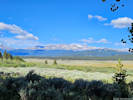
View of Mount Massive across Tennessee Park. | Photographed 20 July 2023.
Location records that use this photograph:
Article records that use this photograph:
images/20230719_090118sm.jpg
| 
View across Tennessee Park to Mount Massive, a little later in the day. | Photographed 21 Jul 2022.
Location records that use this photograph:
Article records that use this photograph:
images/20220721_104847sm.jpg
| Twin Lakes
| 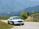
The Sheriff waits for you at Twin Lakes. | Photographed 18 August 2021.
Location records that use this photograph:
Article records that use this photograph:
images/20210818_135836sm.jpg
| Twin Lakes Reservoir
| 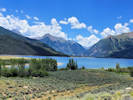
Twin Lakes Reservoir and the canyon of Lake Creek. | Photographed 20 Jul 2022.
Location records that use this photograph:
Article records that use this photograph:
images/20220720_133756sm.jpg
| West Tennessee Creek
| 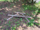
Picnic table parts at the end of the road. | Photographed 19 Jul 2022.
Location records that use this photograph:
Article records that use this photograph:
images/20220719_113938sm.jpg
| 
West Tennessee Creek near the end of the road. | Photographed 19 Jul 2022.
Location records that use this photograph:
Article records that use this photograph:
images/20220719_114142sm.jpg
| 
Westward view on West Tennessee Creek. | Photographed 19 Jul 2022 from the location Coll. No. 2881, Artemisia borealis var. borealis.
Article records that use this photograph:
images/20220719_122648sm.jpg
| 
General view of the flood plain of West Tennessee Creek. | Photographed 18 July 2023. Location of Coll. Nos. 3102 & 3102.1.
Location records that use this photograph:
Article records that use this photograph:
images/20230718_092528sm.jpg
| 
Meadow above West Tennessee Creek with Pedicularis groenlancica and Packera sp. | Photographed 18 July 2023.
Article records that use this photograph:
images/20230718_104856sm.jpg
|
| Date and time this article was prepared: 4/27/2024 3:34:53 PM | |||||||||||