
Eastern Mojave Vegetation
By Tom Schweich
|
Eastern Mojave Vegetation | Images -- Geography - Utah |
|
By Tom Schweich |
|

Unclassified Geography - Idaho Geography - Park County, CO Geography - Summit County, CO Geography - Arizona Geography - British Columbia Geography - California Geography - California's Colorado Desert Alaska Geography - Mono Lake Basin, California Geography - Mono County, California Geography - San Luis Obispo County, California Geography - Marin County, California Geography - Santa Clara County Alameda Garden Geography - Central Mojave Geography - New Mexico Geography - Eastern Mojave Geography - Northern Mojave Geography - Colorado Geography - Alamosa County, CO Geography - Boulder County, CO Geography - Clear Creek County, CO Geography - Chaffee County, CO Geography - Douglas County, CO Geography - Gilpin County, CO Geography - Golden, Colorado Geography - Weld County, CO Geography - Hinsdale County, CO Geography - Jefferson County, CO Geography - North Table Mountain, Jefferson Cty, CO Geography - Lake County, CO Geography - Larimer County, CO Geography - Nevada Geography - Oregon Geography - Utah Geography - Virginia Geography - Washington Geography - Wyoming Spain - Andalucia Spain - Castilla y Leon Spain - Castilla-La Mancha Spain - Extremadura Spain - Galicia Spain - Madrid Portugal Geology Economic Geology Climatology Botany Salvia dorrii Frasera albomarginata Species Species - Polygonaceae Species - Brassicaceae Species - Brassicaceae, Physaria vitulifera Species - Rosaceae Species - Fabaceae Species - Onagraceae Species - Polemoniaceae Species - Boraginaceae Species - Plantaginaceae Species - Asteraceae Species - Poaceae Zoology Ecology Archeology Customer Satisfaction General Arizona California Kansas Missouri Nebraska New York Christmas 2002 Family Photos Family Documents Family Photos 2003 Art of Lydia Schweich Portraits Railroad Geography - Germany |
Images are organized by the topics listed at left. Click on a topic name to see images with that topic. Would you like to use these photographs in your school term paper or report? License is hereby granted for non-commercial use of the images contained herein provided that the images are reproduced with the copyright notice intact. This means that we give you our permission to use the photographs and information you find here in your school term papers and reports. You may resize the photograph to fit your needs, but you may not remove the copyright. Your term paper should note that the photographs are reproduced with permission and it should have a reference to this web site, such as: "Photograph �1999 Tom Schweich. Used by permission, http://www.schweich.com" If you have a comment or a question about a photograph you may write to me at tas4@schweich.com I will answer you as soon as I can. I sometimes post interesting questions in my FAQ, but I will not disclose your full name or address.
| 
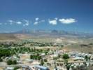
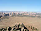
Hurricane, Utah, looking southwest from a pullout on Utah Highway 59. | Photograph taken May 31, 2005.
Location records that use this photograph:
Article records that use this photograph:
images/IMGP1348sm.jpg
| 
Green River in Green River, UT | Photograph taken in August 2003.
Location records that use this photograph:
Article records that use this photograph:
images/TS2938-R1-21A.jpg
| 
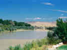
Colorado River upstream of Moab. | Photograph taken in August 2003.
Location records that use this photograph:
Article records that use this photograph:
images/TS2938-R1-15A.jpg
| 
The Bonneville Salt Flats from the Rest Stop on US I-80. | Photograph taken in August 2003. The horizontal lines on the hills in the distance are shorelines of Lake Bonneville.
Location records that use this photograph:
Article records that use this photograph:
images/TS1938-R1-2.jpg
| 
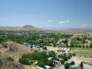
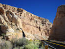
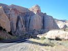
Hurricane as seen from the Hurricane Cliffs on the east. | Photograph taken May 31, 2005, from a pullout on Utah Highway 59, where the highway climbs up the cliff face. The Pine Valley Mountains are seen in the distance.
Location records that use this photograph:
Article records that use this photograph:
images/IMGP1347sm.jpg
| 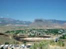
La Verkin and the Hurricane Cliffs. | Photograph taken May 31, 2005. The town in the foreground is La Verkin. In the lower right corner, Utah Highway 9 crosses the Virgin River in its gorge. The Hurricane Cliffs are the left face of the ridge in the center. This photo looks along the axis of the cliffs, as it was taken from Utah Highway 59 where it climbs up the face of the cliffs.
Location records that use this photograph:
Article records that use this photograph:
images/IMGP1349sm.jpg
| 
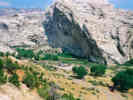
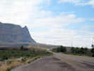
Fort Harmony and the Harmony Mountains across US I-15. | Photograph taken May 31, 2005 from the access road into Kolob Canyons.
Article records that use this photograph:
images/IMGP1355sm.jpg
| 
View westward of the San Francisco Mountains from near Milford, Utah. | Photograph taken June 1, 2005.
Location records that use this photograph:
Article records that use this photograph:
images/IMGP1356sm.jpg
| 
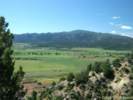
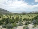
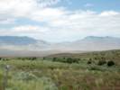
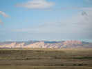
View south from near Milford. | Photograph taken June 1, 2005. The valley is called the Escalante Desert, the middle ground mountains are the Black Mountains, and the Pine Valley Mountains are in the distance.
Location records that use this photograph:
Article records that use this photograph:
images/IMGP1357sm.jpg
| 
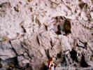
Bee Hive ovens at the Frisco Mine, Utah. | Photograph taken June 1, 2005.
Location records that use this photograph:
Article records that use this photograph:
images/IMGP1359sm.jpg
| 
Frisco Mine workings. | Photograph taken June 1, 2005.
Location records that use this photograph:
Article records that use this photograph:
images/IMGP1360sm.jpg
| 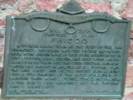
Plaque for town of Frisco. | Photograph taken June 1, 2005. Daughters of Utah Pioneers Frisco A typical mining town at the foot of the San Francisco Mountain (sic?) was fed by the fabulously rich horn silver mine. By 1885 over $60,000,000 in zinc, copper, lead, silver, and gold were hauled away by mule train and the Utah Central Railroad. Water was shipped in as well as all supplies. The the mine caved and people moved away, leaving only a few families of the 4,000 population to maintain their homes, stores, school, and church. By the 1920's only memories and the shifting sands were left. Horn Silver Camp
Location records that use this photograph:
Article records that use this photograph:
images/IMGP1364sm.jpg
| 
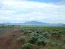
Looking west through Wah Wah Summit. | Photograph taken June 1, 2005.
Location records that use this photograph:
Article records that use this photograph:
images/IMGP1368sm.jpg
| 
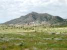
Looking north into the Wah Wah Mountains from Wah Wah Summit. | Photograph taken June 1, 2005.
Location records that use this photograph:
Article records that use this photograph:
images/IMGP1369sm.jpg
| 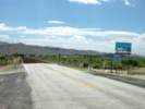
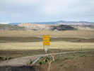
The beginning of Utah Highway 21 | Photograph taken June 1, 2005.
Location records that use this photograph:
Article records that use this photograph:
images/IMGP1372sm.jpg
| 
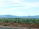
Looking west across Wah Wah Valley to the Wah Wah Mountains. | Photograph taken June 1, 2005, from the east side of the San Francisco Mountains.
Location records that use this photograph:
Article records that use this photograph:
images/IMGP1366sm.jpg
| Arches National Park
| 
Trail to Delicate Arch | Photograph taken in August 2003. The trail sign says it's 1.5 miles from the trail head to Delicate Arch. The first half of this trail climbs across this bare sandstone outcrop.
Location records that use this photograph:
Article records that use this photograph:
images/TS2938-R1-10A.jpg
| 
Arches at the Windows. | Photograph taken in August 2003.
Location records that use this photograph:
Article records that use this photograph:
images/TS2938-R1-2A.jpg
| 
Trailside discussion with a Ranger. | Photograph taken in August 2003.
Location records that use this photograph:
Article records that use this photograph:
images/TS2938-R1-11A.jpg
| 
Cheryl rests on the trail to Delicate Arch. | Photograph taken in August 2003.
Location records that use this photograph:
Article records that use this photograph:
images/TS2938-R1-6A.jpg
| 
Delicate Arch | Photograph taken in August 2003.
Location records that use this photograph:
Article records that use this photograph:
images/TS2938-R1-8A.jpg
| 
Turret Arch | Photograph taken in August 2003.
Location records that use this photograph:
Article records that use this photograph:
images/TS2938-R1-3A.jpg
| Bonneville Salt Flats
| 
US I-80 rest stop in the middle of the Bonneville salt flats. | Photograph taken August 17, 2003.
Location records that use this photograph:
Article records that use this photograph:
images/DSCN1037sm.jpg
| Boulder Mountain
| 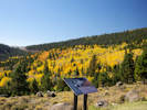
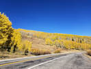
Turning aspens at Larb Hollow Overlook | Photographed October 8, 2017.
Article records that use this photograph:
images/IMGQ4396sm.jpg
| 
Interpretive panel | Photographed October 8, 2017.
Location records that use this photograph:
Article records that use this photograph:
images/IMGQ4400sm.jpg
| 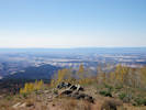
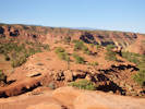
View south from Boulder Mountain | Photographed October 8, 2017. Circle Cliffs in the middleground, with Straight Cliffs in the distance.
Location records that use this photograph:
Article records that use this photograph:
images/IMGQ4399sm.jpg
| 
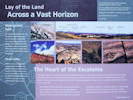
Interpretive panel at Larb Hollow Overlook. | Photographed October 8, 2017.
Article records that use this photograph:
images/20171008_105733sm.jpg
| 
Turning aspens on Boulder Mountain | Photographed October 8, 2017.
Article records that use this photograph:
images/20171008_111501sm.jpg
| 
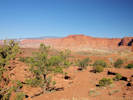
View across Waterpocket Fold to San Rafael Desert | Photographed October 8, 2017. The San Rafael Swell is faintly visible in the left distance.
Article records that use this photograph:
images/IMGQ4397sm.jpg
| Bryce Canyon National Park
| 
View of the cliffs at Bryce Canyon National Park. | Photograph taken June 8, 2008.
Location records that use this photograph:
Article records that use this photograph:
images/IMG00923sm.jpg
| Capitol Reef National Park
| 
Switchbacks on the Burr Trail | Photograph taken June 7, 2008.
Location records that use this photograph:
Article records that use this photograph:
images/IMG00889sm.jpg
| 
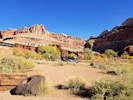
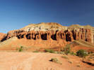
Oyster Shell Reef on top of the Waterpocket Fold. | Photograph taken June 7, 2008.
Location records that use this photograph:
Article records that use this photograph:
images/IMG00890sm.jpg
| 
Landscape above the Waterpocket Fold | Photograph taken June 7, 2008.
Article records that use this photograph:
images/IMG00892sm.jpg
| 
View of top side of Capitol Reef. | Photograph taken June 7, 2008.
Location records that use this photograph:
Article records that use this photograph: images/IMG00888sm.jpg
| 
Switchback on the Burr Trail Road | Photograph taken June 7, 2008.
Article records that use this photograph:
images/IMG00891sm.jpg
| 
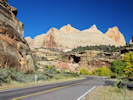
Burr Trail Road entrance to Capitol Reef National Park | Photograph taken June 7, 2008.
Location records that use this photograph:
Article records that use this photograph:
images/IMG00898sm.jpg
| 
Small mesa near Panorama point. | Photographed October 8, 2017.
Location records that use this photograph:
Article records that use this photograph:
images/IMGQ4395sm.jpg
| 
Near Park Headquarters. | Photographed October 8, 2017.
Location records that use this photograph:
Article records that use this photograph:
images/20171008_100751sm.jpg
| 
Canyon in Capitol Reef National Park along Utah Highway 24 | Photographed October 8, 2017.
Location records that use this photograph:
Article records that use this photograph:
images/IMGQ4389sm.jpg
| 
Canyon in Capitol Reef National Park along Utah Highway 24 | Photographed October 8, 2017.
Article records that use this photograph:
images/IMGQ4391sm.jpg
| 
Small mesa near Panorama point. | Photographed October 8, 2017.
Location records that use this photograph:
Article records that use this photograph:
images/IMGQ4394sm.jpg
| 
Cliffs at Panorama Point | Photographed October 8, 2017.
Location records that use this photograph:
Article records that use this photograph:
images/IMGQ4393sm.jpg
| 
Canyon in Capitol Reef National Park along Utah Highway 24 | Photographed October 8, 2017.
Location records that use this photograph:
Article records that use this photograph:
images/IMGQ4390sm.jpg
| Carbon County
| 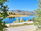
Scofield Reservoir from Mountain View Campground | Photographed 24 September 2022.
Location records that use this photograph:
Article records that use this photograph:
images/20220924_105251sm.jpg
| 
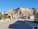
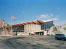
The Western Mining and Railroad Museum in Helper, Utah. | Photographed 24 September 2022.
Location records that use this photograph:
Article records that use this photograph:
images/20220924_091625sm.jpg
| 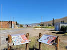
Interpretive site in Scofield, Utah. | Photographed 24 September 2022.
Location records that use this photograph:
Article records that use this photograph:
images/20220924_101747sm.jpg
| 
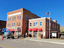
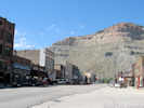
Main Street, Helper, Carbon County, Utah | Photographed 24 September 2022.
Location records that use this photograph:
Article records that use this photograph:
images/20220924_091642sm.jpg
| 
Main Street, Helper, Utah | Photograph taken June 5, 2008.
Location records that use this photograph:
Article records that use this photograph:
images/IMG00853sm.jpg
| 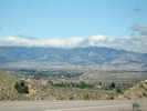
Wellington, Utah, from the east. | Photograph taken June 5, 2008.
Location records that use this photograph:
Article records that use this photograph:
images/IMG00835sm.jpg
| 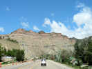
Coming into Helper, Utah, on US Highway 6 | Photograph taken June 5, 2008.
Location records that use this photograph:
Article records that use this photograph:
images/IMG00839sm.jpg
| 
Interpretive Display in Scofield | Photograph taken June 5, 2008.
Location records that use this photograph:
Article records that use this photograph:
images/IMG00843sm.jpg
| 
Interpretive Display about the Winter Quarters Mine Disaster | Photograph taken June 5, 2008.
Location records that use this photograph:
Article records that use this photograph:
images/IMG00844sm.jpg
| 
Scofield Cemetary | Photograph taken June 5, 2008.
Location records that use this photograph:
Article records that use this photograph:
images/IMG00847sm.jpg
| 
Entrance to Miller Canyon. | Photograph taken June 5, 2008.
Location records that use this photograph:
Article records that use this photograph:
images/IMG00850sm.jpg
| Davis County, Antelope Island
| 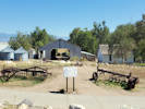
Fielding Garr Ranch on Antelope Island. | Photographed 25 September 2022.
Location records that use this photograph:
Article records that use this photograph:
images/20220925_135430sm.jpg
| 
Bison on Antelope Island. | Photographed 25 September 2022.
Location records that use this photograph:
Article records that use this photograph:
images/20220925_134535sm.jpg
| 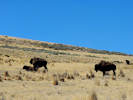
Bison on Antelope Island. | Photographed 25 September 2022.
Location records that use this photograph:
Article records that use this photograph:
images/20220925_132305sm.jpg
| 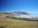
View south from Buffalo Point, across white Rock Bay to Elephant Head. | Photographed 25 September 2022.
Location records that use this photograph:
Article records that use this photograph:
images/IMGQ5675sm.jpg
| 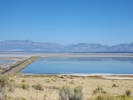
View northeast to the mainland from the Visitor Center at Antelope Island. | Photographed 25 September 2022.
Location records that use this photograph:
Article records that use this photograph:
images/20220925_124812sm.jpg
| Dinosaur National Monument
| 
The quarry at Dinosaur National Monument. | Photograph taken in August 2003.
Location records that use this photograph:
Article records that use this photograph:
images/TS1938-R1-8.jpg
| 
The Green River exits Split Mountain Canyon. | Photograph taken in August 2003.
Location records that use this photograph:
Article records that use this photograph:
images/TS1938-R1-11.jpg
| 
The quarry building at Dinosaur National Monument. | Photograph taken in August 2003.
Location records that use this photograph:
Article records that use this photograph:
images/TS1938-R1-9.jpg
| Emery County
| 
Beckwith Plateau from the side of US Highway 6. | Photographed 23 September 2022.
Location records that use this photograph:
Article records that use this photograph:
images/20220923_153938sm.jpg
| 
Beckwith Plateau from Cedar Mountain Overlook | Photograph taken June 6, 2008.
Location records that use this photograph:
Article records that use this photograph:
images/IMG00864sm.jpg
| 
Location map of Miller Canyon and the Emery Coal Fields |
Location records that use this photograph:
Article records that use this photograph:
images/UTEmeMillerCyn.jpg
| 
Beckwith Plateau as seen from the south, near Green River, Utah | Photograph taken June 5, 2008.
Location records that use this photograph:
Article records that use this photograph:
images/IMG00826sm.jpg
| 
Small butte highlighted by sun through storm clouds. | Photograph taken June 4, 2008.
Article records that use this photograph: images/IMG00821sm.jpg
| 
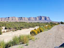
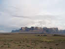
Tilted sediments at southeastern edge of San Rafael Swell | Photograph taken June 4, 2008. Notice the flat-lying sediments at right.
Location records that use this photograph:
Article records that use this photograph:
images/IMG00824sm.jpg
| 
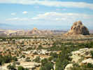
View west off of Cedar Mountain. | Photograph taken June 6, 2008. Cedar Mountain is the northern portion of the San Rafael Swell. Huntington and the Huntington Power Plant are in the left middleground.
Location records that use this photograph:
Article records that use this photograph:
images/IMG00860sm.jpg
| 
View north from Ghost Rock Rest Stop | Photograph taken June 6, 2008.
Location records that use this photograph:
Article records that use this photograph:
images/IMG00883sm.jpg
| 
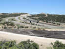
US Interstate 70 on San Rafael Swell east of Ghost Rock Rest Stop | Photograph taken June 6, 2008.
Location records that use this photograph:
Article records that use this photograph:
images/IMG00878sm.jpg
| 
US Interstate 70 at Exit 116, the "Moore Cut Off Road" | Photograph taken June 6, 2008.
Location records that use this photograph:
Article records that use this photograph:
images/IMG00877sm.jpg
| 
View west on Moore Cut Off Road. | Photograph taken June 6, 2008. Photograph taken from a ridge just above US Interstate 70.
Location records that use this photograph:
Article records that use this photograph:
images/IMG00876sm.jpg
| 
View east on Moore Cut Off Road. | Photograph taken June 6, 2008. Looking east, up the west limb of the San Rafael swell anticline. US Interstate 70 is just over the ridge.
Location records that use this photograph:
Article records that use this photograph:
images/IMG00875sm.jpg
| 
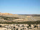
View to south of San Rafael Swell from Cedar Mountain Overlook | Photograph taken June 6, 2008. View south-southwest. The canyon in the middleground contains the San Rafael River, crossing from west to east, right to left.
Location records that use this photograph:
Article records that use this photograph:
images/IMG00861sm.jpg
| 
Sheepherder in Castle Valley. | Photograph taken June 6, 2008.
Article records that use this photograph:
images/IMG00873sm.jpg
| 
San Rafael Swell, southeast edge, in the morning sun. | Photograph taken June 5, 2008.
Location records that use this photograph:
Article records that use this photograph:
images/IMG00827sm.jpg
| 
View across Huntington Reservoir in the early morning. | Photograph taken June 6, 2008.
Location records that use this photograph:
Article records that use this photograph:
images/IMG00858sm.jpg
| 
General view of Mounds, Utah | Photograph taken June 5, 2008.
Location records that use this photograph:
Article records that use this photograph:
images/IMG00837sm.jpg
| 
Mounds, Utah, on the Union Pacific Railroad. | Photograph taken June 5, 2008.
Location records that use this photograph:
Article records that use this photograph:
images/IMG00836sm.jpg
| 
Profile of Beckwith Plateau seen from Woodside, Utah | Photograph taken June 5, 2008.
Location records that use this photograph:
Article records that use this photograph:
images/IMG00832sm.jpg
| 
Green River Cut-Off Road | Photograph taken June 5, 2008. I'm pretty sure this is Emery County Road 401 (EM401). I was thinking of going up this road, but it was too muddy.
Article records that use this photograph:
images/IMG00830sm.jpg
| | ||||||||||||||||||||