
Eastern Mojave Vegetation
By Tom Schweich
|
Eastern Mojave Vegetation | Images -- Geology |
|
By Tom Schweich |
|

Unclassified Geography - Idaho Geography - Park County, CO Geography - Summit County, CO Geography - Arizona Geography - British Columbia Geography - California Geography - California's Colorado Desert Alaska Geography - Mono Lake Basin, California Geography - Mono County, California Geography - San Luis Obispo County, California Geography - Marin County, California Geography - Santa Clara County Alameda Garden Geography - Central Mojave Geography - New Mexico Geography - Eastern Mojave Geography - Northern Mojave Geography - Colorado Geography - Alamosa County, CO Geography - Boulder County, CO Geography - Clear Creek County, CO Geography - Chaffee County, CO Geography - Douglas County, CO Geography - Gilpin County, CO Geography - Golden, Colorado Geography - Weld County, CO Geography - Hinsdale County, CO Geography - Jefferson County, CO Geography - North Table Mountain, Jefferson Cty, CO Geography - Lake County, CO Geography - Larimer County, CO Geography - Nevada Geography - Oregon Geography - Utah Geography - Virginia Geography - Washington Geography - Wyoming Spain - Andalucia Spain - Castilla y Leon Spain - Castilla-La Mancha Spain - Extremadura Spain - Galicia Spain - Madrid Portugal Geology Economic Geology Climatology Botany Salvia dorrii Frasera albomarginata Species Species - Polygonaceae Species - Brassicaceae Species - Brassicaceae, Physaria vitulifera Species - Rosaceae Species - Fabaceae Species - Onagraceae Species - Polemoniaceae Species - Boraginaceae Species - Plantaginaceae Species - Asteraceae Species - Poaceae Zoology Ecology Archeology Customer Satisfaction General Arizona California Kansas Missouri Nebraska New York Christmas 2002 Family Photos Family Documents Family Photos 2003 Art of Lydia Schweich Portraits Railroad Geography - Germany |
Images are organized by the topics listed at left. Click on a topic name to see images with that topic. Would you like to use these photographs in your school term paper or report? License is hereby granted for non-commercial use of the images contained herein provided that the images are reproduced with the copyright notice intact. This means that we give you our permission to use the photographs and information you find here in your school term papers and reports. You may resize the photograph to fit your needs, but you may not remove the copyright. Your term paper should note that the photographs are reproduced with permission and it should have a reference to this web site, such as: "Photograph �1999 Tom Schweich. Used by permission, http://www.schweich.com" If you have a comment or a question about a photograph you may write to me at tas4@schweich.com I will answer you as soon as I can. I sometimes post interesting questions in my FAQ, but I will not disclose your full name or address.
| 
Eclogite P-T Pathways | Redrawn from: Bj�rnerud, M. G., and H Austrheim. 2004. Inhibited eclogite formation: The key to the rapid growth of strong and buoyant Archean continental crust. Geology. 32(9):765-768.
Article records that use this photograph:
images/Eclogite_P-T_Path_2004_10_19.gif
| Aztec Sandstone
| 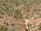
Aztec Tank, type locality of Aztec Sandstone | Photograph taken May 23, 2004.
Location records that use this photograph:
Article records that use this photograph:
images/IMGP0488sm.jpg
| 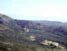
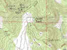
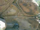
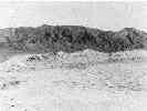
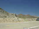
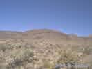
Location of Aztec Tank, type locality of Aztec Sandstone. | This photo was taken from the radio towers on the ridge above Goodsprings. The arrow shows the approximate location of Aztec Tank.
Location records that use this photograph:
Article records that use this photograph:
images/DSCN0941sm.jpg
| 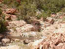
Aztec Tank, type locality of Aztec Sandstone | Photograph taken May 23, 2004. There are petroglyphs in the desert varnish on the right side of the creek bed.
Location records that use this photograph:
Article records that use this photograph:
images/IMGP0485sm.jpg
| 
Location of Aztec Tank | Courtesy of USGS.
Location records that use this photograph:
Article records that use this photograph:
images/nvaztectank.jpg
| Field Trips
| 
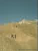
Field discussion about dinosaur tracks in California. | Photograph taken April 21, 2001 at the Dinosaur Trackway in the Mescal Range. Kokoweef Peak in the background.
Location records that use this photograph:
Article records that use this photograph:
images/0022_3291_4597_22.jpg
| 
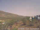
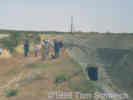
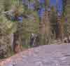
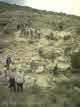
Field trip stop between Cave Spring and Denning Spring. | During a field trip stop between Cave Spring and Denning Spring, north of Fort Irwin, this group from the 1998 Desert Research Symposium has a discussion of east-west trending fault zones in the western Awawatz Mountains. The left-lateral Garlock fault zone is mapped along the base of the hills in the foreground. Telescope Peak in the Panamint Mountains can be seen in the distance. Southern Death Valley is in the right middle-ground.
Article records that use this photograph:
images/ftirwinstop4.jpg
| Garlock Fault Zone
| 
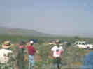
Field trip stop in the Drinkwater Valley | During a field trip stop in the Drinkwater Valley, Terry Pavlis of the University of New Orleans discusses the evidence for 90 degrees of clockwise rotation of the Avawatz Mountains in the late Cenozoic (Pavlis et al., 1998).
images/ftirwinstop2.jpg
| 
A group from the 1998 Desert Research Symposium views the trace of the Garlock Fault. | This depression on the south side of the Garlock Fault was formed when Goler Wash was offset left-laterally (Calzia and Reynolds 1998).
Article records that use this photograph:
images/3221-81.jpg
| 
Field trip stop at the north portal of a southern Pacific tunnel just south of Searles station. | Faulting and rock sources suggest compression along the Garlock Fault (Calzia and Reynolds 1998).
Article records that use this photograph:
images/3221-82.jpg
| 
Field discussion of evidence for movement and amount of offset across the Garlock Fault. | The Independence dike swarm, offset by the Garlock Fault near this location, was the first measured evidence of the magnitude of displacement on the Garlock Fault (Calzia and Reynolds 1998).
Article records that use this photograph:
images/3221-83.jpg
| Geomorphology
| 
Tafoni on Barber Mountain. | Photographed in April 1981.
Location records that use this photograph:
Article records that use this photograph:
images/1981-04-2-1-img221sm.jpg
| 
Shoreline Butte in Death Valley National Monument. |
Article records that use this photograph:
images/cashorelinebutte.jpg
| 
Moat around rock on Table Top. | Small moats in the soils around rocks as shown in this photograph are common on Table Top. How the moats form is uncertain. However, it has been found that coarse particles will emerge from desert soils after as few as 4 wetting and drying cycles (Cook and Warren, 1973, p. 128). Once a rock like this emerges at the surface, continued rain runoff from the surface of the rock may wash the very fine particles away from the rock and cause a localized deflation around its edges.
Article records that use this photograph:
images/tabletoprockmoat.jpg
| 
Unusual deep weathering pattern. | Caruthers Canyon, on the road to the Giant Ledge Mine.
Article records that use this photograph:
images/0072_3301_0700_27.jpg
| 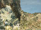
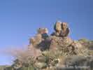
Arch in Bonanza King Canyon | In the photo on the left, Matt sits inside the arch. The arch is formed at the intersection of two faults. One fault that parallels the plane of the photo seems to be a reverse fault. A second fault can be seen at the upper right of the left photograph. The arch itself is formed by a rock fall from the hanging wall of the reverse fault, where the hanging wall has been weakened by intersection of the second fault visible in the photo. Photograph taken in April, 1987. The arch is inside the red circle of the photograph at right, which was taken from the location of the red circle in the photograph at left.
Location records that use this photograph:
Article records that use this photograph:
images/8745-8n10.jpg
| 
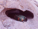
Ventifact on top of Ventifact Hill | The easily accessible vertifacts at "Ventifact Hill," east of Afton Canyon, are just a few of the many spectacular examples of sandblasted rocks that are to be found in the east-central Mojave Desert. Most of the ventifacts in this region are fossil or relict in nature, attesting to a time of greater sediment availability and possibly higher velocity winds (Laity,2000).
Article records that use this photograph:
images/1440-20.jpg
| Geomorphology, Sand Dunes
| 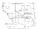
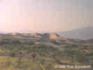
Figure 1. Location map of sand dunes described in this report. |
Article records that use this photograph:
images/TM86Fig1.gif
| 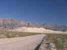
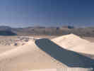
Eureka Sand Dunes | As seen from South Eureka Road. Photograph taken October 5, 2000.
Location records that use this photograph:
Article records that use this photograph:
images/0091_3182_0174_17.jpg
| 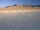
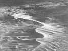
Ripples in the sand at Eureka Sand Dunes | Photograph taken October 7, 2000.
Location records that use this photograph:
Article records that use this photograph:
images/0091_3182_0174_19.jpg
| 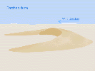
Diagram of a Barchan dune. | Barchan dunes form in areas with a limited source of sand, and a constant wind direction.
images/dunebarchan.gif
| 
Sand dunes at Stovepipe Wells in the late afternoon. |
Location records that use this photograph:
Article records that use this photograph:
images/stovepipewellsdunes.jpg
| 
Kelso Dunes | From Trexler and Melhorn, 1986.
Location records that use this photograph:
Article records that use this photograph:
images/TM86CAKelsoDunes.jpg
| 
The Cronese "Cat" | The Cronese "Cat," a falling sand dune on the west side of the Cronese Basin.
Location records that use this photograph:
Article records that use this photograph:
images/3201-18.jpg
| 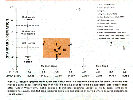
Figure 2. Grain size vs. standard deviation of grain size. | Full figure caption: "Figure 2. Inclusive graphic mean grain size versus inclusive standard deviation for some California and Nevada sand dunes showing region in which booming sounds would be expected. Size classification after Udden-Wentworth. Solid symbols indicate booming sound in field, open symbols indicate no sounds. Shaded area indicates grain size and degree of sorting where acoustic phenomena should occur."
Article records that use this photograph:
images/TM86Fig2.gif
| 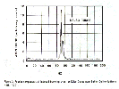
Figure 3. Fourier components of induced booming event at Kelso Dunes near Baker, California (from Haff, 1979). |
Article records that use this photograph:
images/TM86Fig3.gif
| 
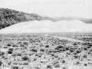
Sand Mountain, Nevada | From Trexler and Melhorn, 1986.
Location records that use this photograph:
Article records that use this photograph:
images/TM86NVSandMtn.jpg
| 
The crest of the Eureka Dunes. | Photograph taken October 7, 2000. Yes, those are my foot prints.
Location records that use this photograph:
Article records that use this photograph:
images/0091_3182_0174_23.jpg
| 
Winnemucca Dunes, Nevada |
Article records that use this photograph:
images/TM86NVWinnemuccaDunes.jpg
| 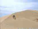
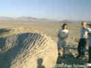
Matt near the top of the Kelso Dunes. |
Location records that use this photograph:
Article records that use this photograph:
images/3252-28.jpg
| 
Eureka Sand Dunes, California. Photo by R. Rust. | This photograph was published in the Trexler and Melhorn (1986) article.
Article records that use this photograph:
images/TM86CAEurekaDunes.jpg
| Glacialogy
| 
Devil's Postpile. | The top of the Postpile looks like this, the columns have been polished by glaciers.
Article records that use this photograph:
images/GlacialPolishBasalt.jpg
| History
| 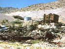
Bonanza King Mine. | The 7IL Ranch Road is the preferred road for Bonanza King Canyon, and the Bonanza King Mine. This photograph shows the remains of the mill at the Bonanza King Mine, as it appeared in 1981.
Location records that use this photograph:
Article records that use this photograph:
images/bonking.jpg
| Paleozoic
| 
Outcrop of fossiliferous Paleozoic limestone along Kelbaker Road. |
Article records that use this photograph:
images/2907-23.jpg
| 
Close-up of fossiliferous limestone on Kelbaker Road. |
Article records that use this photograph:
images/2907-24.jpg
| Peach Springs Tuff
| 
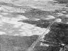
Peach Springs Tuff and Tertiary gravels at the mouth of Keystone Canyon, New York Mountains. |
Article records that use this photograph:
images/fn19950522210.gif
| Rock Units
| 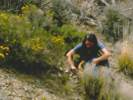
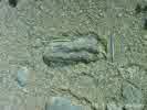
Julie looks for trilobite fossils in the Latham Shale. | This is one of several outcrops of the Latham Shale in the Providence Mountains. It is Hazzard's (1933, 1954) locality P-11.
Article records that use this photograph:
images/1621-17.jpg
| 
Solitary horn coral found in Bonanza King Canyon. | Found in a dark gray limestone with crinoids and brachiopods, it likely is from the late Paleozoic, from the Pennsylvannian (Matt McMackin, personal communication). In the eastern Mojave, as well as southern Nevada, the late Paleozoic is found in the Monte Cristo Formation and the Bird Spring Formation.
Article records that use this photograph:
images/1621-16.jpg
| 
Piute Canyon. | Lake beds at the head of Piute Canyon, on the west side of the Piute Range.
Article records that use this photograph:
images/ftpiutelakebeds.jpg
| 
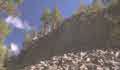
Metaconglomerate. | There are numerous outcrops of meta-conglomerate in the area near the Golden Quail mine. Conglomerate is a sedimentary rock of sand and rounded gravel. When it is slightly metamorphosed by heat and pressure, the mineral grains interlock between the gravel and the sand, so it becomes a single rock called "metaconglomerate" with a texture that looks like sand and gravel. When the rock is fractured, as the rock face is in this photograph, the fracture cuts right through what used to be individual pebbles, giving this natural terrazzo effect.
Article records that use this photograph:
images/gqmetacon.jpg
| 
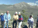
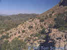
Winkler Formation at Hackberry Mountain. | Hackberry Mountain is one of the three places that the informally named "Winkler Formation" crops out. The other two locations are the north slope of Wild Horse Mesa and Pinto Mountain. The people in the photograph are on a field trip with the Desert Research Symposium, held by the San Bernardino County Museum, May, 1995.
Location records that use this photograph:
Article records that use this photograph:
images/hackwink.jpg
| 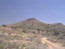
Miocene pyroclastic rocks on the south flank of the New York Mountains. | I believe this to be an outcrop of the Wild Horse Mesa Tuff on top of the Peach Springs Tuff. This hill is on the south flank of the New York Mountains, and would be the northernmost outcrop of Wild Horse Mesa Tuff.
Article records that use this photograph:
images/3182-57.jpg
| 
Metasandstone. | This picture, and the next two were taken on the first hill south of New York Mountain Road, and north of the Golden Quail mine. It shows the swirling deformed bedding planes in the metasandstone.
Article records that use this photograph:
images/nykmetass.jpg
| 
Tower of granite in the Mid Hills. |
Article records that use this photograph:
images/3252-59.jpg
| 
Winkler Formation at Pinto Mountain. |
Location records that use this photograph:
Article records that use this photograph:
images/pintwink.jpg
| 
Location of Hazzard's Locality P-11 |
Article records that use this photograph:
images/Hazzard_1933_Site_P-11.jpg
| 
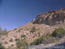
Winkler formation on the north face of Wild Horse Mesa. | The exposures of Winkler formation on the north face of Wild Horse Mesa are not quite as dramatic as those on Pinto Mountain. Nevertheless, the white rocks across the center of the photograph are Winkler Formation.
Article records that use this photograph:
images/3201-21.jpg
| 
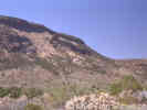
Tectonic breccia. | This outcrop of tectonic breccia alongside Wild Horse Canyon Road contains Mid Hills adamellite with tumbled blocks of Precambrian gneiss (Reynolds and Reynolds, 1995).
Article records that use this photograph:
images/tecbrec.jpg
| 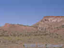
Peach Springs Tuff, Winkler Formation, and Wild Horse Mesa Tuff on the south side of Pinto Mountain. | View of Winkler Formation on the south side of Pinto Mountain. The lower unit on the left is Peach Springs Tuff. The middle unit, just right of center, is Winkler Formation. The volcanic unit in the upper right is Wild Horse Mesa Tuff.
Article records that use this photograph:
images/3201-69.jpg
| 
Winkler Formation, with Cedar Canyon in the background. | The top of the Winkler Formation is the ledge at bottom right.
Location records that use this photograph:
Article records that use this photograph:
images/3221-62.jpg
| 
Winkler Formation on the south side of Pinto Mountain | Outcrop of Winkler Formation on the south side of Pinto Mountain is seen in the lower left portion of the photograph. Hole-in-the-Wall tuff is above it.
Article records that use this photograph:
images/3221-64.jpg
| 
Miocene rhyolitic dome in lower Wild Horse Canyon. | McCurry (1985) identified this structure as the oldest Miocene volcanic structure in the eastern Mojave.
Article records that use this photograph:
images/wilhordome.jpg
| 
Solitary horn coral in Bonanza King Canyon | Photographed April 1984, scanned from a print 6 February 2018.
Location records that use this photograph:
Article records that use this photograph:
images/8443-18-sm.jpg
| Structural Geology
| 
Slickensides near Golden Quail mine. | George Hilton (deceased) examines some exposed slickensides in a small adit on the east side of the hill near the Golden Quail mine. Perhaps this is one trace of the Cedar Canyon Fault.
Article records that use this photograph:
images/geocedcynfault.jpg
| Ubehebe Crater
| 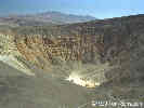
Ubehebe Crater |
Location records that use this photograph:
Article records that use this photograph:
images/2907-70.jpg
| Volcanism
| 
Devil's Postpile. | Here is my picture of the Postpile. Took this one in late morning, on a Fall day. The lighting would be better in mid afternoon for photography.
Article records that use this photograph:
images/DevilsPostpile.jpg
| 
Lake Mary. | Take the Lake Mary Road to see the area where trees have been killed by Carbon Dioxide gasses at Horseshoe Lake. For more information see Gases and Tree Kill on Mammoth Mountain in Long Valley caldera, California.
Article records that use this photograph:
images/DeadTrees.jpg
|
| Date and time this article was prepared: 4/14/2024 5:45:20 PM | |||||||||||||