
Eastern Mojave Vegetation
By Tom Schweich
|
Eastern Mojave Vegetation | Images -- Geography - Colorado |
|
By Tom Schweich |
|

Unclassified Geography - Idaho Geography - Park County, CO Geography - Summit County, CO Geography - Arizona Geography - British Columbia Geography - California Geography - California's Colorado Desert Alaska Geography - Mono Lake Basin, California Geography - Mono County, California Geography - San Luis Obispo County, California Geography - Marin County, California Geography - Santa Clara County Alameda Garden Geography - Central Mojave Geography - New Mexico Geography - Eastern Mojave Geography - Northern Mojave Geography - Colorado Geography - Alamosa County, CO Geography - Boulder County, CO Geography - Clear Creek County, CO Geography - Chaffee County, CO Geography - Douglas County, CO Geography - Gilpin County, CO Geography - Golden, Colorado Geography - Weld County, CO Geography - Hinsdale County, CO Geography - Jefferson County, CO Geography - North Table Mountain, Jefferson Cty, CO Geography - Lake County, CO Geography - Larimer County, CO Geography - Nevada Geography - Oregon Geography - South Dakota Geography - Utah Geography - Virginia Geography - Washington Geography - Wyoming Spain - Andalucia Spain - Castilla y Leon Spain - Castilla-La Mancha Spain - Extremadura Spain - Galicia Spain - Madrid Portugal Geology Economic Geology Climatology Botany Salvia dorrii Frasera albomarginata Species Species - Polygonaceae Species - Brassicaceae Species - Brassicaceae, Physaria vitulifera Species - Rosaceae Species - Fabaceae Species - Onagraceae Species - Polemoniaceae Species - Boraginaceae Species - Plantaginaceae Species - Asteraceae Species - Poaceae Zoology Ecology Archeology Customer Satisfaction General Arizona California Kansas Missouri Nebraska New York Christmas 2002 Family Photos Family Documents Family Photos 2003 Art of Lydia Schweich Portraits Railroad Geography - Germany |
Images are organized by the topics listed at left. Click on a topic name to see images with that topic. Would you like to use these photographs in your school term paper or report? License is hereby granted for non-commercial use of the images contained herein provided that the images are reproduced with the copyright notice intact. This means that we give you our permission to use the photographs and information you find here in your school term papers and reports. You may resize the photograph to fit your needs, but you may not remove the copyright. Your term paper should note that the photographs are reproduced with permission and it should have a reference to this web site, such as: "Photograph �1999 Tom Schweich. Used by permission, http://www.schweich.com" If you have a comment or a question about a photograph you may write to me at tomas@schweich.com I will answer you as soon as I can. I sometimes post interesting questions in my FAQ, but I will not disclose your full name or address.
| 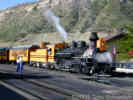
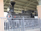
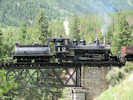
Durango and Silverton Narrow Gauge Railroad. | Photograph taken in August 2003.
Location records that use this photograph:
Article records that use this photograph:
images/DSCN1050.jpg
| 
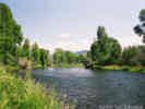
Lunch along the Crystal River in Redstone, CO. | Photograph taken in August 2003. Left to right: Cheryl, Matt, Simone, and Becci.
Location records that use this photograph:
Article records that use this photograph:
images/TS1938-R1-17.jpg
| 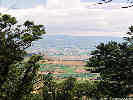
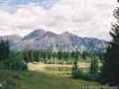
Looking toward Montrose, CO from Black Canyon of the Gunnison National Park. | Photograph taken in August 2003.
Article records that use this photograph:
images/TS3938-R1-9.jpg
| 
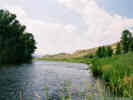
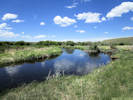
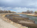
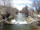
The Colorado River between Kremmling and Hot Sulphur Springs. | Photograph taken in August 2003. Looking east and up stream.
Location records that use this photograph:
Article records that use this photograph:
images/TS1938-R1-14.jpg
| 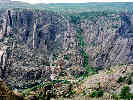
Looking into Black Canyon of the Gunnison. | Photograph taken in August 2003.
Article records that use this photograph:
images/TS3938-R1-5.jpg
| 
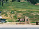
Lost Lake Slough | Photograph taken in August 2003. I guess in this area of Colorado low swampy areas that were improved to be lakes by an artificial dam are called "sloughs."
Article records that use this photograph:
images/TS3938-R1-3.jpg
| 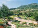
Yampa River Botanic Park in Steamboat Springs | Photograph taken in August 2003.
Location records that use this photograph:
Article records that use this photograph:
images/TS1938-R1-12.jpg
| 
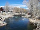
The Colorado River between Kremmling and Hot Sulphur Springs. | Photograph taken in August 2003. Looking west and down stream.
Location records that use this photograph:
Article records that use this photograph:
images/TS1938-R1-15.jpg
| 
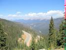
Berthoud Pass, Continental Divide, 11,307 feet. | Photograph taken in August 2003.
Location records that use this photograph:
Article records that use this photograph:
images/TS1938-R1-16.jpg
| 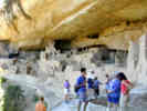
Cheryl talks with two young people from the Bay Area at the Cliff Palace. | Photograph taken August 26, 2003.
Article records that use this photograph:
images/DSCN1058sm.jpg
| 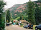
The town of Redstone. | Photograph taken in August 2003.
Location records that use this photograph:
Article records that use this photograph:
images/TS1938-R1-19.jpg
| 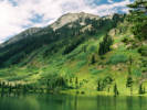
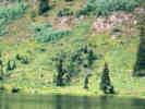
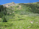
Dollar Lake, near Crested Butte. | Photograph taken in August 2003.
Location records that use this photograph:
Article records that use this photograph:
images/TS1938-R1-22.jpg
| 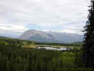
View of Lost Lake Slough from the trail to Dollar Lake. | Photograph taken August 23, 2003.
Article records that use this photograph:
images/DSCN1048sm.jpg
| 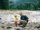
Matt and Simone by the Crystal River. | Photograph taken in August 2003.
Location records that use this photograph:
Article records that use this photograph:
images/TS1938-R1-18.jpg
| 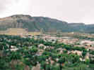
Overview of Durango, Colorado. | Photograph taken in August 2003.
Location records that use this photograph:
Article records that use this photograph:
images/TS3938-R1-10.jpg
| 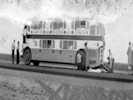
Bus in Colorado |
June 9, 1936
Article records that use this photograph:
images/1936BusinColorado.jpg
| Frasera speciosa
| 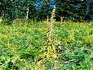
Frasera speciosa that has finished blooming. | Photograph taken in August 2003.
Article records that use this photograph:
images/TS1938-R1-24.jpg
| 
Many Frasera speciosa at Dollar Lake. | Photograph taken in August 2003.
Article records that use this photograph:
images/TS1938-R1-20.jpg
| 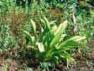
Rosette of Frasera speciosa at Dollar Lake, CO. | Photograph taken in August 2003.
Article records that use this photograph:
images/TS1938-R1-23.jpg
| Alamosa County
| 
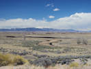
Sierra Blanca east of Colorado Highway 150. | Photographed 4 April 2016.
Location records that use this photograph:
Article records that use this photograph:
images/IMGQ2157sm.jpg
| 
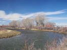
Rio Grande River at the Alamosa - Rio Grande County line. | Photographed 5 April 2016. This view looks east into Alamosa County.
Location records that use this photograph:
Article records that use this photograph:
images/IMGQ2190sm.jpg
| 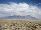
Blowing sand with Sierra Blanca in the background | Photographed 5 April 2016.
Location records that use this photograph:
Article records that use this photograph:
images/IMGQ2204sm.jpg
| Alamosa National Wildlife Refuge
| 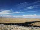
San Luis Valley and the San Juan Mountains from Hansen Bluff | Photographed 5 April 2016.
Location records that use this photograph:
Article records that use this photograph:
images/IMGQ2211sm.jpg
| 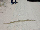
Gopher snake sunning in the road at Hansen Bluff | Photographed 5 April 2016.
Location records that use this photograph:
Article records that use this photograph:
images/IMGQ2216sm.jpg
| 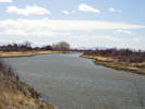
Rio Grande River in the Alamosa National Wildlife Refuge | Photographed 5 April 2016. This view looks south and down river.
Location records that use this photograph:
Article records that use this photograph:
images/IMGQ2196sm.jpg
| 
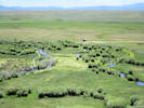
Big Slough of the Rio Grande River, the San Luis Valley and the San Juan Mountains | Photographed 5 April 2016. The name “Big Slough” appears on USGS maps, but is not present in the GNIS.
Location records that use this photograph:
Article records that use this photograph:
images/IMGQ2223sm.jpg
| 
Rio Grande River in the Alamosa National Wildlife Refuge | Photographed 5 April 2016.
Location records that use this photograph:
Article records that use this photograph:
images/IMGQ2197sm.jpg
| Anasazi Heritage Center
| 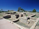
Anasazi pueblo. | Photographed 21 April 2017.
Article records that use this photograph:
images/IMGQ3886sm.jpg
| 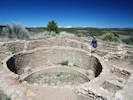
Anasazi pueblo. | Photographed 21 April 2017.
Article records that use this photograph:
images/IMGQ3885sm.jpg
| Apex
| 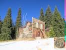
Cabin in the near-ghost town of Apex. | Photographed 29 November 2014. Brass plaque shows this building to be Gilpin County Historical Landmark No. 1.
Location records that use this photograph:
Article records that use this photograph:
images/IMG40697sm.jpg
| 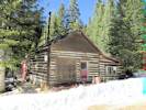
Cabin in the near-ghost town of Apex. | Photographed 29 November 2014.
Location records that use this photograph:
Article records that use this photograph:
images/IMG40696sm.jpg
| 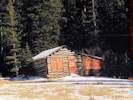
Cabin in the near-ghost town of Apex. | Photographed 29 November 2014.
Location records that use this photograph:
Article records that use this photograph:
images/IMG40695sm.jpg
| Arapaho National Wildlife Refuge
| 
Nature trail on the Illinois River. | Photographed 19 June 2018.
Location records that use this photograph:
Article records that use this photograph:
images/IMG50340sm.jpg
| 
Illinois River in Arapaho National Wildlife Refuge. | Photographed 19 June 2018.
Location records that use this photograph:
Article records that use this photograph:
images/IMG50341sm.jpg
| Berthoud Pass
| 
View north from Berthoud Pass | Photographed 24 September 2014.
Location records that use this photograph:
Article records that use this photograph:
images/IMG40512sm.jpg
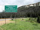
| Cameron Pass
| 
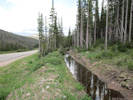
Cameron Pass Ditch transport ditch | Photographed 18 June 2018. Water is flowing away from the viewer, and crosses under the highway in the right distance.
Article records that use this photograph:
images/IMG50293sm.jpg
| 
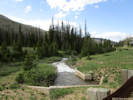
Water-gathering ditches join and cross under the highway in a culvert. | Photographed 18 June 2018. Water enters from the lower left, and comes toward the viewer on the upper left, then crosses under the highway in a culvert, then in an open ditch and culvert to the far side of the highway at upper right.
Article records that use this photograph:
images/IMG50292sm.jpg
| 
South water-gathering ditch of Cameron Pass Ditch | Photographed 18 June 2018. The water is coming toward the viewer.
Article records that use this photograph:
images/IMG50291sm.jpg
| 
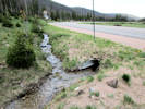
The water from Michigan Ditch exits through a gaging station. | Photographed 18 June 2018
Location records that use this photograph:
Article records that use this photograph:
images/IMG50288sm.jpg
| 
Interpretive panel for Forest Conservation. | Photographed 18 June 2018.
Location records that use this photograph:
Article records that use this photograph:
images/IMG50283sm.jpg
| 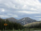
View a little east of south to Lulu Mountain on the right and Thunder Mountain on the left. | Photographed 18 June 2018
Location records that use this photograph:
Article records that use this photograph:
images/IMG50285sm.jpg
| 
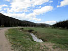
Cameron Pass, Larimer and Jackson Counties, Elevation 10, 276 feet. | Photographed 18 June 2018. The concrete culvert in the middle ground is the end of the Michigan Ditch, while the little structure in the right middleground is the gaging station for the Cameron Ditch. Both ditches flow under Colorado Highway 14, and away to the right enroute to Joe Wright Creek.
Location records that use this photograph:
Article records that use this photograph:
images/IMG50290sm.jpg
| 
Michigan Ditch approaches Colorado Highway 14. | Photographed 18 June 2018. The water to flowing toward the photographer and is approaching Colorado Highway 14 at Cameron Pass. It will cross the divide from the Michigan River (North Platte River basin) into Joe Wright Creek (Cache La Poudre Riverm South Platte River basin).
Article records that use this photograph:
images/IMG50287sm.jpg
| 
Interpretive panel at Cameron Pass. | Photographed 18 June 2018.
Location records that use this photograph:
Article records that use this photograph:
images/IMG50282sm.jpg
| 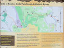
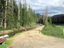
Informational sign for Cache la Poudre - North Park Scenic and Historic Byway. | Photographed 18 June 2018
Location records that use this photograph:
Article records that use this photograph:
images/IMG50284sm.jpg
| Ca�on City
| 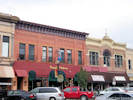
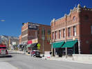
Two old buildings on Main Street, Canon City | Photographed 18 September 2017. Found on Main Street between 5th and 6th Streets.
Article records that use this photograph:
images/IMGQ4256sm.jpg
| 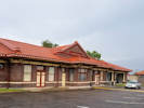
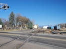
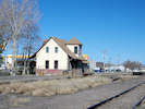
A former railroad depot in Canon City | Photographed 17 September 2017. Not sure which railroad built this depot,but it is very nicely constructed like the Union Pacific depot in Greeley.
Location records that use this photograph:
Article records that use this photograph:
images/20170917_121420sm.jpg
| 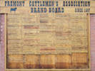
Fremont Cattlemen's Association Brand Board | Photographed 18 September 2017. Found on N. 5th Street just north of Main Street.
Article records that use this photograph:
images/IMGQ4252sm.jpg
| Chaffee County, Buena Vista
| 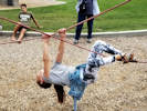
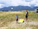
Sofia figures out how to do the crossed ropes. | Photographed 7 August 2019.
Article records that use this photograph:
images/20190807_161804sm.jpg
| Chaffee County, Elephant Rock
| 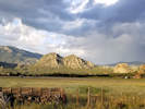
Elephant Rock across from Jumpin' Good Goat Dairy. | Photographed 5 August 2019.
Location records that use this photograph:
Article records that use this photograph:
images/20190805_192346sm.jpg
| Chaffee County, Jumpin' Good Goat Dairy
| 
Ian and Nico playing corn hole. | Photographed 7 August 2019.
Article records that use this photograph:
images/20190807_130019sm.jpg
| 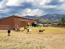
Goats at the dairy. | Photographed 7 August 2019.
Article records that use this photograph:
images/20190807_124350sm.jpg
| 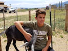
Ian and a goat. | Photographed 7 August 2019.
Article records that use this photograph:
images/20190807_125153sm.jpg
| Chaffee County, Trout Creek Pass
| 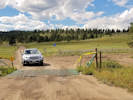
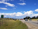
East end of County Road 311. | Photographed 5 August 2019.
Location records that use this photograph:
Article records that use this photograph:
images/20190805_160112sm.jpg
| 
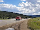
Northeast on US Highway 285. | Photographed 5 August 2019.
Location records that use this photograph:
Article records that use this photograph:
images/20190805_160101sm.jpg
| 
Southwest on US Highway 285. | Photographed 5 August 2019.
Location records that use this photograph:
Article records that use this photograph:
images/20190805_160107sm.jpg
| Cheyenne County
| 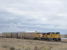
UP 8977 and UP 7254 pulling a string of empty tri-levels eastbound between Kit Carson and Cheyenne Wells, Colorado. | Photographed 28 April 2016.
Article records that use this photograph:
images/IMGQ2541sm.jpg
| 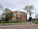
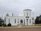
Cheyenne County Court House | Photographed 28 April 2016.
Location records that use this photograph:
Article records that use this photograph:
images/20160428_115443sm.jpg
| 
Old Jail Museum in Cheyenne Wells. | Photographed 28 April 2016.
Location records that use this photograph:
Article records that use this photograph:
images/IMGQ2533sm.jpg
| Cheyenne Mountain State Park
| 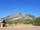
Cheyenne Montain from the state park. | Photographed 10 September 2017.
Location records that use this photograph:
Article records that use this photograph:
images/20170910_082528sm.jpg
| City of Alamosa
| 
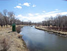
The Rio Grande River in downtown Alamosa. | Photographed 5 April 2016.
Location records that use this photograph:
Article records that use this photograph:
images/IMGQ2245sm.jpg
| 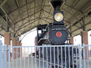
D&RGW 169 on display at Cole Park in Alamosa | Photographed 5 April 2016. Well-fenced, impossible to obtain a good photograph.
Location records that use this photograph:
Article records that use this photograph:
images/IMGQ2230sm.jpg
| 
D&RGW 169 on display at Cole Park in Alamosa | Photographed 5 April 2016. Well-fenced, impossible to obtain a good photograph.
Location records that use this photograph:
Article records that use this photograph:
images/IMGQ2236sm.jpg
| City of Buena Vista
| 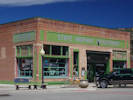
Repurposed building with sporting goods and a yummy caf e. | Photographed 6 April 2016.
Location records that use this photograph:
Article records that use this photograph:
images/IMGQ2298sm.jpg
| 
Midland Hill east of Buena Vista | Photographed 6 April 2016.
Location records that use this photograph:
Article records that use this photograph:
images/IMGQ2294sm.jpg
| 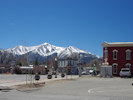
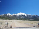
Mount Princeton west of Buena Vista | Photographed 6 April 2016.
Location records that use this photograph:
Article records that use this photograph:
images/IMGQ2293sm.jpg
| City of Monte Vista
| 
Monte Vista depot and the San Luis and Rio Grande Railroad. | Photographed 6 April 2016.
Location records that use this photograph:
Article records that use this photograph:
images/IMGQ2254sm.jpg
| 
Monte Vista Depot. | Photographed 6 April 2016.
Location records that use this photograph:
Article records that use this photograph:
images/IMGQ2262sm.jpg
| 
Colorado Potato Administrative Committee in Monte Vista. | Photographed 6 April 2016.
Location records that use this photograph:
Article records that use this photograph:
images/IMGQ2257sm.jpg
| City of Salida
| 
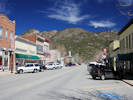
A bit of downtown Salida. | Photographed 6 April 2016.
Location records that use this photograph:
Article records that use this photograph:
images/IMGQ2292sm.jpg
| 
Arkansas River in downtown Salida | Photographed 6 April 2016.
Location records that use this photograph:
Article records that use this photograph:
images/IMGQ2291sm.jpg
| 
Arkansas River in downtown Salida | Photographed 6 April 2016.
Location records that use this photograph:
Article records that use this photograph:
images/IMGQ2286sm.jpg
| Clear Creek County
| 
Avalanche Chute | Photograph taken 13 August 2011.
Article records that use this photograph:
images/IMG_2382sm.jpg
| 
Another lower fen. | Photograph taken 13 August 2011.
Location records that use this photograph:
Article records that use this photograph:
images/IMG_2378sm.jpg
| 
A lower fen. | Photograph taken 13 August 2011.
Location records that use this photograph:
Article records that use this photograph:
images/IMG_2376sm.jpg
| 
Georgetown Loop locomotive at Lebanon Silver Mine | Photograph taken 4 Aug 2011.
Article records that use this photograph:
images/IMG21908sm.jpg
| 
Opposite side of creek from avalanche chute. | Photograph taken 13 August 2011.
Article records that use this photograph:
images/IMG_2383sm.jpg
| 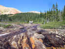
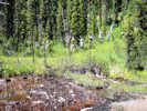
View upstream in center of Josephine Creek fen. | Photograph taken 13 August 2011.
Location records that use this photograph:
Article records that use this photograph:
images/IMG_2371sm.jpg
| 
The Whole Crew at Guanella Pass | Photograph taken 8 Aug 2011.
Location records that use this photograph:
Article records that use this photograph:
images/IMG_0386sm.jpg
| 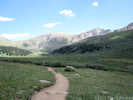
Hiking Trail to the South | Photograph taken 8 Aug 2011.
Location records that use this photograph:
Article records that use this photograph:
images/IMG_2328sm.jpg
| 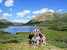
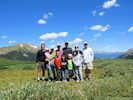
Group photo on Guanella Pass | Photograph taken 8 Aug 2011.
Location records that use this photograph:
Article records that use this photograph:
images/IMG_0404sm.jpg
| 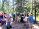
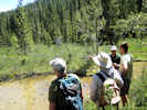
Field trip briefing for Josephine Creek iron fens | Photograph taken 13 August 2011.
Location records that use this photograph:
Article records that use this photograph:
images/IMG_2352sm.jpg
| | |||||||||||||||||||||||||||||||||||||